Text consolidated by Valsts valodas centrs (State
Language Centre) with amending laws of:
16 December 2010 [shall
come into force on1 January 2011].
If a whole or part of a section has been amended, the
date of the amending law appears in square brackets at
the end of the section. If a whole section, paragraph or
clause has been deleted, the date of the deletion appears
in square brackets beside the deleted section, paragraph
or clause.
|
The Saeima1 has adopted and
the President has proclaimed the following law:
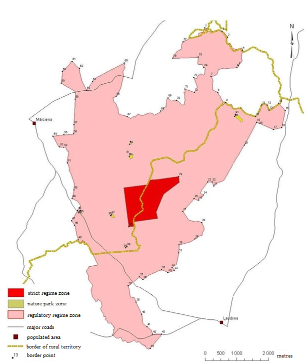
Krustkalni
Strict Nature Reserve Law
Chapter I
General Provisions
Section 1.
The Krustkalni Strict Nature Reserve (hereinafter - the
Reserve) is a specially protected nature territory of State
significance.
Section 2.
The Reserve has been established for the purpose of preserving
biological diversity of the forest and water ecosystem complex
that is typical for Latvia, coniferous forests on forms of
ash-type relief, biotopes and species related to freshwater
chalk, and also landscape and cultural and historical values of
the Reserve.
Section 3.
The Reserve has a total area of 2978 hectares and its borders
have been determined in accordance with the Krustkalni Strict
Nature Reserve plan (Annex 1) and the description of borders of
the Krustkalni Strict Nature Reserve (Annex 2).
Section 4.
The administration of the Reserve shall be implemented by the
Nature Conservation Agency (hereinafter - the Agency) that is an
institution of direct administration subordinate to the Minister
for Environmental Protection and Regional Development.
[16 December 2010]
Chapter
II
Functional Zones
Section 5.
The territory of the Reserve shall be divided into the
following functional zones:
1) the strict regime zone;
2) the regulatory regime zone;
3) the nature park zone.
Section 6.
(1) The strict regime zone has been established in order to
ensure natural development of ecosystems that are typical for the
Reserve.
(2) The strict regime zone shall not permit any economic
activity, and also construction of buildings and structures.
(3) Stay in the strict regime zone is prohibited, it may be
visited only with authorisation of the Agency for research and
protection purposes.
Section 7.
(1) The regulatory regime zone has been established in order
to ensure diversity of species and biotopes in the Reserve, to
study the development of ecosystems and their elements, and also
to promote public understanding of the environment under minimal
anthropogenic pressure.
(2) It is prohibited in the regulatory regime zone to:
1) stay without a written authorisation of the Agency or the
presence of the employees from the Agency. This prohibition shall
not apply to the persons residing in the territory of the
Reserve;
2) use any chemical plant protection products;
3) carry out forestry activity, except for tree felling for
the establishment and maintenance of the forest infrastructure,
landscaping, removal of dangerous trees, and preservation of
biological diversity;
4) carry out other economic activity which is in contradiction
to the objectives of establishing the Reserve, the requirements
for the protection of species and biotopes;
5) gather forest non-wood material values, including wild
berries and mushrooms.
Section 8.
(1) The nature park zone has been established in order to
preserve the historical extensive types of environmental
management and to balance out the interests of nature protection,
environmental education, and local residents.
(2) It is prohibited in the nature park zone to:
1) change the category of the use of land;
2) sow and plant osier, Sakhalin knotweed, lupins, and
lucerne;
3) set up enclosed outdoor nurseries for wild animal
species;
4) fell trees in a final felling;
5) change the hydrological regime of surface water and
underground water, except where it necessary for the protection
of species and biotopes, preservation or enlargement of
biological diversity;
6) use mineral fertilisers, chemical plant protection
products, and also other dangerous chemical substances and
products outside of yards and gardens;
7) grub up and cultivate, and also otherwise damage or destroy
biologically valuable grasslands;
8) change the natural land relief, damage or destroy landscape
elements of ecological and aesthetic significance (natural and
man-made sites and territories significant for the preservation
of biological diversity and the specific landscape);
9) extract mineral resources, except for the extraction of
drinking water for personal use;
10) burn dry grass, leaves, and reeds outside of yards and
gardens, except where it is necessary for carrying out measures
for the protection of biotopes and a written authorisation has
been received from the institution responsible for fire safety
and fire service activities;
11) introduce the species of flora and fauna that are foreign
to local conditions in natural habitats.
Section 9.
Bird hunting shall be banned and hunting of production
specially protected mammals shall be limited in the territory of
the Reserve. Hunting of other species of mammals in the territory
of the Reserve shall be permissible in accordance with the
hunting district plan.
Chapter
III
Administration of the Reserve
Section 10.
The Agency shall coordinate activities that may have a
negative impact on the natural development of ecosystems of the
Reserve, populations of plant and animal species.
Section 11.
Draft spatial plans at all levels concerning the territory of
the Reserve shall be harmonised with the Agency.
Section 12.
It is prohibited for natural and legal persons to collect
natural materials for collections, to carry out studies,
measurements, survey, or monitoring, and also to photograph and
film for commercial purposes in the territory of the Reserve
without a written authorisation of the Agency.
Section 13.
The Agency shall be exempt from the court costs in claims for
compensation for losses incurred due to violation of the laws and
regulations governing environmental protection and use of natural
resources if such losses are recovered in favour of State.
Section 14.
The functions of the Advisory Council of the Krustkalni Strict
Nature Reserve shall be performed by the Advisory Council of the
Teiči Strict Nature Reserve which has been established in
accordance with the Teiči Strict Nature Reserve Law.
Transitional
Provisions
1. With the coming into force of this Law, the Krustkalni
Strict Nature Reserve Law (Latvijas Republikas Saeimas un
Ministru Kabineta Ziņotājs, 2000, No. 9) is repealed.
2. The Reserve shall be administered by the administration of
the Teiči Strict Nature Reserve until 1 June 2009.
3. Until the date of the local government of the Madona
municipality beginning work according to the Law on
Administrative Territories and Populated Areas, the term "Madona
municipality, Prauliena rural territory" used in Sub-paragraph
1.1 of Annex 2 to this Law shall mean the term "district of
Madona, Prauliena rural territory", the term "Madona
municipality, Mārciena rural territory" used in Sub-paragraph 1.2
shall mean the term "district of Madona, Mārciena rural
territory", the term used in Sub-paragraph 1.3 "Madona
municipality, Ļaudona rural territory" shall mean the term
"district of Madona, Ļaudona rural territory", the term "Madona
municipality, Mārciena rural territory" used in Sub-paragraph 1.4
shall mean the term "district of Madona, Mārciena rural
territory".
The Law has been adopted by the Saeima on 30 April
2009.
Acting for the President, the Chairperson
of the Saeima G. Daudze
Rīga, 20 May 2009
Krustkalni Strict Nature Reserve
Law
Annex 1
Krustkalni
Strict Nature Reserve Plan
Krustkalni Strict Nature Reserve
Law
Annex 2
Description of
the Borders of the Krustkalni Strict Nature Reserve
1. Description
of the External Border
|
No.
|
Numbers of border sections
according to the plan
|
The situation elements of the
plan according to which the border has been determined
|
|
1
|
2
|
3
|
| 1.1. |
|
Madona municipality, Prauliena
rural territory |
| 1.1.1. |
1-2
|
From the border point of the
Mārciena and Prauliena rural territories due east, south, and
east along the border of the property "Mežlāči" (cadastre No.
70860120088) to the border of the property "Irbes" (cadastre
No. 70860120099) |
| 1.1.2. |
2-3
|
Due south-east along the
border of the property "Irbes" (cadastre No. 70860120099) to
the border of the property "Vālodzes" (cadastre No.
70860120040) |
| 1.1.3. |
3-4
|
Due south and south-east
along the border of the property "Vālodzes" (cadastre No.
70860120040) to the border of the property "Priednieki"
(cadastre No. 70740070007) (it coincides with the border
point of the Prauliena and Mārciena rural territories) |
| 1.2. |
|
Madona municipality, Mārciena
rural territory |
| 1.2.1. |
4-5
|
Due south along the border of
the property "Priednieki" (cadastre No. 70740070007) to the
border of the property "Stirnas" (cadastre No.
70740070017) |
| 1.2.2. |
5-6
|
Due west and south along the
border of the property "Stirnas" (cadastre No. 70740070017)
to the border of the property "Zīles" (cadastre No.
70740070003) |
| 1.2.3. |
6-7
|
Due south-west along the
border of the property "Zīles" (cadastre No. 70740070003) to
the western corner of the property "Zīles" |
| 1.2.4. |
7-8
|
Due south and south-east
along the border of the property "Zīles" (cadastre No.
70740070003) to the border of the property "Dvīņi" (cadastre
No. 70740070010) |
| 1.2.5. |
8-9
|
Due south-east and north-east
along the border of the property "Dvīņi" (cadastre No.
70740070010) to the border of the property "Paleinieki"
(cadastre No. 70740070002) |
| 1.2.6. |
9-10
|
Due south-east along (the
River) Niedruškas upe and the border of the property
"Paleinieki" (cadastre No. 70740070002) to the furthest
southern point at (the River) Niedruškas upe |
| 1.2.7. |
10-11
|
Due north-east along (the
River) Niedruškas upe and the border of the property
"Paleinieki" (cadastre No. 70740070002) to the border of the
property "Dvīņi" (cadastre No. 70740070016) |
| 1.2.8. |
11-12
|
Due east along (the River)
Niedruškas upe and the border of the property "Dvīņi"
(cadastre No. 70740070016) to the border of the property
"Āžukalni" (cadastre No. 70740070006) |
| 1.2.9. |
12-13
|
Due south-east along the
border of the property "Āžukalni" (cadastre No. 70740070006)
to the southern corner of the property "Āžukalni" at the
amelioration ditch |
| 1.2.10. |
13-14
|
Due north-east along the
border of the property "Āžukalni" (cadastre No. 70740070006)
in the Mārciena rural territory to the border of the property
"Āžukalni" (cadastre No. 70700020017) in the Ļaudona rural
territory (it coincides with the border point of the Mārciena
and Ļaudona rural territories) |
| 1.3. |
|
Madona municipality, Ļaudona
rural territory |
| 1.3.1. |
14-15
|
Due south-east along the
border of the property "Āžukalni" (cadastre No. 70700020017)
to the turning point of the property "Āžukalni" in a
south-western direction |
| 1.3.2. |
15-16
|
Due south-west along the
border of the property "Āžukalni" (cadastre No. 70700020017)
to the border of the property "Inči" (cadastre No.
70700020088) |
| 1.3.3. |
16-17
|
Due south-west along the
border of the property "Inči" (cadastre No. 70700020088) to
the border of the property "Dālderi" (cadastre No.
70700020034) |
| 1.3.4. |
17-18
|
Due north-west along the
borders of the properties "Dālderi" (cadastre No.
70700020034) and "Darbiņi" (cadastre No. 70700020027) to the
border of the property "Zemturi" (cadastre No.
70700020046) |
| 1.3.5. |
18-19
|
Due south-west along the
border of the property "Zemturi" (cadastre No. 70700020046)
to the northern corner of the property "Zemturi" |
| 1.3.6. |
19-20
|
Due south-west along the
border of the property "Zemturi" (cadastre units No.
70700020046 and No. 70700020035) to the border of the
property "Ciedri" (cadastre No. 70700020010) |
| 1.3.7. |
20-21
|
Due south-west along the
borders of the properties "Ciedri" (cadastre No.
70700020010), "Lieljoksti" (cadastre No. 70700020021),
"Joksti" (cadastre No. 70700020024), "Lejasjoksti" (cadastre
No. 70700020041), "Ievmalas" (cadastre No. 70700020096), and
"Purnavieši" (cadastre No. 70700020073) to the border of the
property "Trieķēļi" (cadastre No. 70700030031) |
| 1.3.8. |
21-22
|
Due north-west along the
border of the property "Trieķēļi" (cadastre No. 70700030031)
to the turning point of the border "Trieķēļi"in a western
direction |
| 1.3.9. |
22-23
|
Due west along the border of
the property "Trieķēļi" (cadastre No. 70700030031) to the
turning point of the border of the property "Trieķēļi" in a
south-western direction |
| 1.3.10. |
23-24
|
Due south-west and south-east
along the border of the property "Trieķēļi" (cadastre No.
70700030031) to the turning point of the border "Trieķēļi"in
a south-western direction |
| 1.3.11. |
24-25
|
Due south-west and south
along the border of the property "Trieķēļi" (cadastre No.
70700030031) to the border of the property "Gundegas"
(cadastre No. 70700030090) |
| 1.3.12. |
25-26
|
Due north-west along the
border of the property "Gundegas" (cadastre No. 70700030090)
to the northern corner of the property "Gundegas" |
| 1.3.13. |
26-27
|
From the northern corner of
the property "Gundegas" (cadastre No. 70700030090) due
south-west along the borders of the properties "Gundegas" and
"Palejnieki" (cadastre No. 770700030062) to the western
corner of the property "Palejnieki" |
| 1.3.14. |
27-28
|
From the western corner of
the property "Palejnieki" (cadastre No. 70700030062) due
south-east along the border of the property "Palejnieki" to
the border of the property "Mežvidi" (cadastre No.
70700030098) |
| 1.3.15. |
28-29
|
Due south and south-west
along the border of the property "Mežvidi" (cadastre units
No. 70700030098 and No. 70700030008) and along the local
government road of the Ļaudona rural territory to the border
of the property "Upenieki" (cadastre No. 70700030068) |
| 1.3.16. |
29-30
|
Due south-west along the
border of the property "Upenieki" (cadastre No. 70700030068)
to the north-western corner of the property "Upenieki" |
| 1.3.17. |
30-31
|
Due south along the border of
the property "Upenieki" (cadastre No. 70700030068) by
crossing (the River) Svētupe to the border of the property
"Vecupenieki" (cadastre No. 70700070046) |
| 1.3.18. |
31-32
|
Due south and south-west
along the border of the property "Vecupenieki" (cadastre No.
70700070046) to the border of the property "Bērzkalni 2"
(cadastre No. 70700070532) |
| 1.3.19. |
32-33
|
Due south-east along the
external border of the property "Bērzkalni 2" (cadastre No.
70700070532) to the eastern corner of the property "Bērzkalni
2" |
| 1.3.20. |
33-34
|
Due south-west along the
external border of the property "Bērzkalni 2" (cadastre No.
70700070532) to the southern corner of the property
"Bērzkalni 2" |
| 1.3.21. |
34-35
|
Due north-west along the
external border of the property "Bērzkalni 2" (cadastre No.
70700070532) to the intersection of the borders of the
properties "Grāvmalas 2" (cadastre No. 70700070329) and "Ūpji
2" (cadastre No. 70700070308) |
| 1.3.22. |
35-36
|
Due south-west along the
external borders of the properties "Ūpji 2" (cadastre No.
70700070308), "Āriņi 3" (cadastre No. 70700070296), and
"Austrumi 2" (cadastre No. 70700070099) to the south-western
corner of the property "Austrumi 2" |
| 1.3.23. |
36-37
|
Due north-west along the
border of the property "Austrumi 2" (cadastre No.
70700070099) to the border of the property "Apsiņi" (cadastre
No. 70700070071) |
| 1.3.24. |
37-38
|
Due south-west by crossing
the "V876 Ļaudona-Mārciena" State motor road (cadastre No.
70700010001) along the border of the property "Apsiņi"
(cadastre units No. 70700070071 and 70700070070) to the
north-western corner of the property "Apsiņi" |
| 1.3.25. |
38-39
|
Due south and south-east
along the border of the property "Apsiņi" (cadastre No.
70700070070) to the border of the property "Romas" (cadastre
No. 70700070123) |
| 1.3.26. |
39-40
|
Due south-east along the
border of the property "Romas" (cadastre No. 70700070123) to
the border of the property "Mazā Roma" (cadastre No.
70700070017) |
| 1.3.27. |
40-41
|
Due south and south-east
along the border of the property "Mazā Roma" (cadastre No.
70700070017) to the border of the property "Ceriņi" (cadastre
No. 70700070049) |
| 1.3.28. |
41-42
|
Due south-east along the
border of the property "Ceriņi" (cadastre No. 70700070049) to
the "P82 Ļaudona-Jaunkalsnava" State motor road (cadastre No.
70700010002) |
| 1.3.29. |
42-43
|
Due south by crossing the
"P82 Ļaudona-Jaunkalsnava" State motor road (cadastre No.
70700010002) then due east along the southern side of the
abovementioned motor road to the "Radziņi-Vēverāres" local
government road (cadastre No. 70700070538) |
| 1.3.30. |
43-44
|
Due south-west along the
"Radziņi-Vēverāres" local government road (cadastre No.
70700070538), the borders of the property "Ceriņi" (cadastre
No. 70700070050) and the "Radziņi-Vēverāres" local government
road (cadastre No. 70700070538) to the border of the property
"Vēverāres" (cadastre No. 70700070004) at (the River) Nirīte
upe |
| 1.3.31. |
44-45
|
Along (the River) Nirīte upe and the borders of the
properties "Vēverāres" (cadastre No. 70700070004),
"Svarukalni" (cadastre No. 70700070131), "Svarukalni"
(cadastre No. 70700070291), and "Nirītes" (cadastre No.
70700070128) by crossing the
"P82 Ļaudona-Jaunkalsnava" State motor road (cadastre
No. 70700010002) further along (the River) Nirīte upe and
the borders of the properties "Jokas" (cadastre No.
70700060029), "Leitāni" (cadastre No. 70700060037),
"Leitāni" (cadastre No. 70700060007), "Stabiņi" (cadastre
No. 70700060123), "Koki" (cadastre No. 70700060124),
"Leitāni" (cadastre No. 70700060070), "Priedulas" (cadastre
No. 70700060048), "Jaunķepši" (cadastre No. 70700060091),
"Ogas" (cadastre No. 70700060118), and "Getliņi" (cadastre
No. 70700060047) to the border of the property "Mētras"
(cadastre No. 70740080028) (it coincides with the border
point of the Mārciena and Ļaudona rural territories)
|
| 1.4. |
|
Madona municipality, Mārciena
rural territory |
| 1.4.1. |
45-46
|
Due north along (the River)
Nirītes upe to the border of the property "Ķepši" (cadastre
No. 70740080033) |
| 1.4.2. |
46-47
|
Due north-west along the
border of the property "Ķepši" (cadastre No. 70740080033) to
the border of the property "Rūķīši" (cadastre No.
70740080037) |
| 1.4.3. |
47-48
|
Due north-east along the
border of the property "Rūķīši" (cadastre No. 70740080037) by
crossing the "V876 Ļaudona-Mārciena" State motor road
(cadastre No. 70740050006) to the border of the property
"Jaunjānēni" (cadastre No. 70740080105) |
| 1.4.4. |
48-49
|
Due north-east and north-west
along the border of the property "Jaunjānēni" (cadastre No.
70740080105) by crossing the "Graulītes-Dreimaņi" local
government road (cadastre No. 70740050012) to the border of
the property "Oliņi" (cadastre No. 70740080060) |
| 1.4.5. |
49-50
|
Due north along the property
"Oliņi" (cadastre No. 70740080060) to the border of the
property "Kalnarandoti" (cadastre No. 70740080057) |
| 1.4.6. |
50-51
|
Due north and north-west
along the borders of the properties "Kalnarandoti" (cadastre
No. 70740080057), "Lejas Randoti" (cadastre No. 70740080043),
"Jaunrandoti" (cadastre No. 70740080046) to the border of the
property "Jaunjānēni" (cadastre No. 70740080027) |
| 1.4.7. |
51-52
|
Due north and north-west
along the border of the property "Jaunjānēni" (cadastre No.
70740080027) to the border of the property "Kalna Jānēni"
(cadastre No. 70740080087) |
| 1.4.8. |
52-53
|
Due north-west along the
border of the property "Kalna Jānēni" (cadastre No.
70740080087) by crossing the "Ozolu iela-Atceres" local
government road (cadastre No. 70740080103) to the border of
the property "Dambakalns" (cadastre No. 70740080029) |
| 1.4.9. |
53-54
|
Due west along the border of
the property "Dambakalns" (cadastre No. 70740080029) by
crossing the "Ozolu iela-Atceres" local government road
(cadastre No. 70740080103) and due north-west along the
border of the property "Dambakalns" (cadastre No.
70740080029) to the border of the property "Blieķukalns"
(cadastre No. 70740080059) |
| 1.4.10. |
54-55
|
Due east along the borders of
the properties "Blieķukalns" (cadastre No. 70740040059),
"Blieķukalna senkapi" (cadastre No. 70740040349), "Senkapi"
(cadastre No. 70740040350), and "Silenieki" (cadastre No.
70740040007) to the border of the property "Avotiņi"
(cadastre No. 70740040048) |
| 1.4.11. |
55-56
|
Due east along the border of
the property "Avotiņi" (cadastre No. 70740040048) to the
south-eastern corner of the property "Avotiņi" |
| 1.4.12. |
56-57
|
Due north along the border of
the property "Avotiņi" (cadastre No. 70740040048) to the
border of the property "Paurenes" (cadastre No.
70740040062) |
| 1.4.13. |
57-58
|
Due north along the borders
of the properties "Paurenes" (cadastre No. 70740040062),
"Ozolu iela 9" (cadastre No. 70740040094), "Ozoli" (cadastre
No. 70740040006), and "Silieši" (cadastre No. 70740040030) to
the border of the property "Silieši" (cadastre No.
70740040021) |
| 1.4.14. |
58-59
|
Due north along the border of
the property "Silieši" (cadastre No. 70740040021) by crossing
the "Mārciena-Brāži-Āriņi" local government road (cadastre
No. 70740050025), then in a north-western direction along the
borders of the property Silieši" (cadastre No. 70740040021)
and the property "Silieši" (cadastre No. 70740040031) by
crossing (the River) Austronas upe to the border of the
property "Kaisis" (cadastre No. 70740040127) |
| 1.4.15. |
59-60
|
Due north along the borders
of the properties "Kaisis" (cadastre No. 70740040127) and
"Ezermala" (cadastre No. 70740040079) to the border of the
property "Labonas ezers" (cadastre No. 70740040125) |
| 1.4.16. |
60-61
|
Due north-east along the
border of the property "Labonas ezers" (cadastre No.
70740040125) to the border of the property "Trušļi" (cadastre
No. 70740040020) |
| 1.4.17. |
61-62
|
Due south-east along the
border of the property "Trušļi" (cadastre No. 70740040020) by
crossing (the River) Austronas upe to the turning point of
the border of the property "Trušļi" due south |
| 1.4.18. |
62-63
|
Due south and south-east
along the border of the property "Trušļi" (cadastre No.
70740040020) to the southern corner of the property
"Trušļi" |
| 1.4.19. |
63-64
|
Due north-east along the
border of the "Trušļi" (cadastre No. 70740040020) to the
border of the property "Truslīši" (cadastre No.
70740040221) |
| 1.4.20. |
64-65
|
Due south-east along the
borders of the properties Truslīši" (cadastre No.
70740040221), "Trušļi" (cadastre No. 70740040217), "Zaķi"
(cadastre No. 70740050022), "Mačrubeņi 2" (cadastre No.
70740050001), "Kalna Bālēnas" (cadastre No. 70740050004),
"Asmi" (cadastre No. 70740050008), and "Jaunbrāži" (cadastre
No. 70740050007) to the border of the property "Brāži 1"
(cadastre No. 70740060024) |
| 1.4.21. |
65-66
|
Due south along the border of
the property "Brāži 1" (cadastre No. 70740060024) then by
crossing the "Mārciena-Āriņi-Brāži" local government road
(cadastre No. 70740060070) along the borders of the
properties "Asmi" (cadastre No. 70740060023) and "Mazlāči"
(cadastre No. 70740060025) to the border of the property
"Kalna Lāči" (cadastre No. 70740060040) |
| 1.4.22. |
66-67
|
Due south-west, south, and
south-east along the borders of the properties "Kalna Lāči"
(cadastre No. 70740060040) and "Mazlāči" (cadastre No.
70740060026) to the border point of the property "Kalna Lāči"
(cadastre No. 70740060075) at the electric line |
| 1.4.23. |
67-68
|
From the border point of the
property "Kalna Lāči" (cadastre No. 70740060075) at the
electric line due east along the borders of the properties
"Kalna Lāči" and "Mazlāči" (cadastre No. 70740060025) (the
northern shore of (the Lake) Svētes ezers) to the border of
the property "Dūku ezers" (cadastre No. 70740060046) |
| 1.4.24. |
68-69
|
Due north-east along the
border of the property "Dūku ezers" (cadastre No.
70740060046) (the eastern shore of (the Lake) Dūku ezers) to
the border of the property "Dūki" (cadastre No.
70740060031) |
| 1.4.25. |
69-70
|
Due south-east and east along
the border of the property "Dūki" (cadastre No. 70740060031)
to the border of the property "Vanadziņi" (cadastre No.
70740060067) |
| 1.4.26. |
70-71
|
Due south-east, north-east,
and north along the border of the property "Vanadziņi"
(cadastre No. 70740060067) to the border of the property
"Ineši" (cadastre No. 70740060059) |
| 1.4.27. |
71-72
|
Due south-east by crossing
(the Lake) Vanadziņa ezers along the border of the property
"Ineši" (cadastre No. 70740060059) to the south-eastern
corner of the property "Ineši" |
| 1.4.28. |
72-73
|
Due north-east and north-west
along the border of the property "Ineši" (cadastre No.
70740060059) to the turning point of the border of the
property "Ineši" in a south-eastern direction |
| 1.4.29. |
73-74
|
Due south-east and north-east
along the border of the property "Ineši" (cadastre No.
70740060059) to the border of the property "Baltiņi"
(cadastre No. 70740060018) |
| 1.4.30. |
74-75
|
Due south-west, west, and
north along the border of the property "Baltiņi" to the
border of the property "Kalna Daugavieši" (cadastre No.
70740060008) |
| 1.4.31. |
75-76
|
Due west along the southern
border of the property "Kalna Daugavieši" (cadastre No.
70740060008) to the border point of the property "Kalna
Daugavieši" at (the River) Nesaļa upe |
| 1.4.32. |
76-77
|
Along (the River) Nesaļa upe
and the external border of the property "Kalna Daugavieši"
(cadastre No. 70740060008) due north-east and north to the
border of the property "Graviņas" (cadastre No.
70740060020) |
| 1.4.33. |
77-1
|
Due north-east along the
borders of the properties "Graviņas" (cadastre No.
70740060020), "Lakstīgalas" (cadastre No. 70740060032),
"Mežlāči" (cadastre No. 70860120089), and "Mežlāči" (cadastre
No. 70740060037) to the border of the property "Mežlāči"
(cadastre No. 70860120088) in the Prauliena rural territory
(it coincides with the border point of the Prauliena and
Mārciena rural territories) |
2. Description
of the Borders of the Strict Regime Zone
|
No.
|
Numbers of border sections
according to the plan
|
The situation elements of the
plan according to which the border has been determined
|
|
1
|
2
|
3
|
| 2.1. |
78-79
|
From the south-western corner
of the forest compartment 50 to the border point of the
forest compartments 34, 35, 42, and 43 further due east along
the northern delimiting boundary to (the River) Svētupe along
the River to the northern delimiting boundary of the forest
compartment 36 and along the delimiting boundary to the
border point of the forest compartments 36, 37, 44, and
45 |
| 2.2. |
79-78
|
From the border point of the
forest compartments 36, 37, 44, and 45 due south to the gully
further along it due south-west and south to the border point
of the forest compartments 51, 52, 56, and 57, further due
west to (the River) Svētupe, along the River to the
delimiting boundary of the forest compartment 50 and along
the delimiting boundary to the south-western corner of forest
compartment 50 (to the beginning point of the strict regime
zone) |
3. Description
of the Borders of the Strict Nature Park Zone
|
No.
|
Numbers of border sections
according to the plan
|
The situation elements of the
plan according to which the border has been determined
|
|
1
|
2
|
3
|
| 3.1. |
80-81
|
Along the external border of
the property "Dreimaņi" (cadastre No. 70740050021) |
| 3.2. |
82-83
|
Along the external border of
the property "Rogāni" (cadastre No. 70740050017) |
| 3.3. |
84-85
|
Along the external border of
the property "Graulītes" (cadastre No. 770740050026) |
| 3.4. |
86-87
|
Along the external border of
the farm "Dambri" (without cadastral designation) |
| 3.5. |
88-89
|
Along the external border of
the property "Meirāni" (cadastre No. 70740050020) |
| 3.6. |
90-91
|
Along the external border of
the property "Greizkalni" (cadastre No. 70700010005) |
4. External
Borders and Coordinates of Border Points of Functional Zones
|
No.
|
The number of the border
point
|
X coordinate
|
Y coordinate
|
| 4.1. |
1
|
633656
|
6296722
|
| 4.2. |
2
|
634198
|
6296613
|
| 4.3. |
3
|
634367
|
6296436
|
| 4.4. |
4
|
634844
|
6296025
|
| 4.5. |
5
|
634720
|
6295540
|
| 4.6. |
6
|
634669
|
6295480
|
| 4.7. |
7
|
633844
|
6295218
|
| 4.8. |
8
|
634058
|
6294711
|
| 4.9. |
9
|
634310
|
6294400
|
| 4.10. |
10
|
635255
|
6293962
|
| 4.11. |
11
|
635453
|
6294316
|
| 4.12. |
12
|
635619
|
6294319
|
| 4.13. |
13
|
635675
|
6294158
|
| 4.14. |
14
|
635980
|
6294372
|
| 4.15. |
15
|
636182
|
6294148
|
| 4.16. |
16
|
636070
|
6293615
|
| 4.17. |
17
|
635811
|
6293557
|
| 4.18. |
18
|
635368
|
6293747
|
| 4.19. |
19
|
635284
|
6293782
|
| 4.20. |
20
|
634898
|
6293061
|
| 4.21. |
21
|
633935
|
6291778
|
| 4.22. |
22
|
633884
|
6291906
|
| 4.23. |
23
|
633742
|
6291904
|
| 4.24. |
24
|
633605
|
6291500
|
| 4.25. |
25
|
633468
|
6291342
|
| 4.26. |
26
|
633323
|
6291389
|
| 4.27. |
27
|
632968
|
6290984
|
| 4.28. |
28
|
633561
|
6290640
|
| 4.29. |
29
|
633347
|
6290124
|
| 4.30. |
30
|
632843
|
6289940
|
| 4.31. |
31
|
632834
|
6289691
|
| 4.32. |
32
|
632629
|
6289236
|
| 4.33. |
33
|
632699
|
6289149
|
| 4.34. |
34
|
632498
|
6289083
|
| 4.35. |
35
|
632298
|
6289169
|
| 4.36. |
36
|
631720
|
6288856
|
| 4.37. |
37
|
631609
|
6288940
|
| 4.38. |
38
|
631256
|
6288662
|
| 4.39. |
39
|
631504
|
6288166
|
| 4.40. |
40
|
631679
|
6287788
|
| 4.41. |
41
|
631848
|
6287397
|
| 4.42. |
42
|
632016
|
6287164
|
| 4.43. |
43
|
632300
|
6287166
|
| 4.44. |
44
|
631946
|
6286719
|
| 4.45. |
45
|
629675
|
6290097
|
| 4.46. |
46
|
629563
|
6290554
|
| 4.47. |
47
|
629472
|
6290693
|
| 4.48. |
48
|
629663
|
6291015
|
| 4.49. |
49
|
629491
|
6291387
|
| 4.50. |
50
|
629549
|
6291659
|
| 4.51. |
51
|
629342
|
6292504
|
| 4.52. |
52
|
629228
|
6292995
|
| 4.53. |
53
|
629100
|
6293012
|
| 4.54. |
54
|
628895
|
6293343
|
| 4.55. |
55
|
629236
|
6293385
|
| 4.56. |
56
|
629537
|
6293419
|
| 4.57. |
57
|
629548
|
6293701
|
| 4.58. |
58
|
629585
|
6294498
|
| 4.59. |
59
|
629149
|
6295003
|
| 4.60. |
60
|
629188
|
6295367
|
| 4.61. |
61
|
629489
|
6295675
|
| 4.62. |
62
|
629722
|
6295468
|
| 4.63. |
63
|
629945
|
6294780
|
| 4.64. |
64
|
630131
|
6295057
|
| 4.65. |
65
|
631130
|
6295628
|
| 4.66. |
66
|
630881
|
6294595
|
| 4.67. |
67
|
631224
|
6293951
|
| 4.68. |
68
|
632272
|
6294134
|
| 4.69. |
69
|
632506
|
6294536
|
| 4.70. |
70
|
632769
|
6294460
|
| 4.71. |
71
|
633032
|
6294813
|
| 4.72. |
72
|
633329
|
6294716
|
| 4.73. |
73
|
633309
|
6295178
|
| 4.74. |
74
|
633622
|
6295483
|
| 4.75. |
75
|
633452
|
6295812
|
| 4.76. |
76
|
632656
|
6295780
|
| 4.77. |
77
|
632977
|
6296286
|
| 4.78. |
78
|
631274
|
6290509
|
| 4.79. |
79
|
632838
|
6292078
|
| 4.80. |
80
|
631301
|
6293093
|
| 4.81. |
81
|
631369
|
6293157
|
| 4.82. |
82
|
631317
|
6292627
|
| 4.83. |
83
|
631413
|
6292772
|
| 4.84. |
84
|
629787
|
6290904
|
| 4.85. |
85
|
629728
|
6291000
|
| 4.86. |
86
|
630779
|
6290884
|
| 4.87. |
87
|
630744
|
6290819
|
| 4.88. |
88
|
631169
|
6289849
|
| 4.89. |
89
|
631232
|
6289887
|
| 4.90. |
90
|
634830
|
6293785
|
| 4.91. |
91
|
634624
|
6294022
|
1 The Parliament of the Republic of
Latvia
Translation © 2022 Valsts valodas centrs (State
Language Centre)