The translation of this document is outdated.
Translation validity: 03.06.2011.–06.04.2017.
Amendments not included: 04.04.2017., 19.12.2023.
|
Republic
of Latvia
Cabinet
Regulation No. 418
Adopted 31 May 2011
|
Regulations
Regarding Water Bodies at Risk
Issued pursuant
to
Section 5, Paragraph ten, Clause 11 of
the Water Management Law
1. This Regulation prescribes:
1.1. surface water bodies which are at risk of failing to meet
good surface water status specified in the Water Management Law
within the period of time provided for in the referred to law
(hereinafter - water bodies at risk); and
1.2. the requirements for the protection of water bodies at
risk.
2. List of the water bodies at risk - rivers and channel - and
information concerning the municipalities and territorial units
thereof (rural territories of a municipality and towns) included
in the catchment area of these water bodies is provided for in
Annex 1 to this Regulation.
3. List of the water bodies at risk - lakes and reservoirs -
and information concerning in the territory of which
municipalities and territorial units thereof (rural territories
of a municipality and towns) these water bodies are located is
provided for in Annex 2 to this Regulation.
4. List of the water bodies at risk - coastal waters or
transitional waters - and information concerning the territory of
which municipalities and territorial units thereof (rural
territories of a municipality and towns) borders on these water
bodies is provided for in Annex 3 to this Regulation.
5. Location of the water bodies at risk - rivers, channel,
stretches of coastal waters or transitional waters - is
specified:
5.1. for the river basin district of Daugava - in Annex 4 to
this Regulation;
5.2. for the river basin district of Gauja - in Annex 5 to
this Regulation;
5.3. for the river basin district of Lielupe - in Annex 6 to
this Regulation; and
5.4. for the river basin district of Venta - in Annex 7 to
this Regulation.
6. Public persons and private persons shall use or manage
water resources in the water bodies referred to in Paragraphs 2,
3 and 4 of this Regulation, as well as use or plan to use the
territories in the catchment area thereof so as to prevent or
reduce the possible adverse impact on the water body concerned
and improve the status thereof gradually, taking into account the
requirements specified in the regulatory enactments:
6.1. regarding emission of polluting substances into
water;
6.2. regarding the protection of water and soil from pollution
with nitrates caused by agricultural activity;
6.3. regarding special environmental requirements for
performance of polluting activities in animal housing;
6.4. regarding environmental impact assessment and regarding
technical regulations for the activities for which the
environmental impact assessment is not required;
6.5. regarding plant protection products and regarding
activities with biocides;
6.6. regarding utilisation, monitoring and control of sewage
sludge and the compost thereof;
6.7. regarding a permit for the use of water resources;
6.8. regarding amelioration and the operation and maintenance
of amelioration systems;
6.9. regarding procedures for construction of amelioration
systems and hydrotechnic structures;
6.10. regarding procedures for the cleaning and deepening of
surface water bodies and port basins;
6.11. regarding nature protection regulations in forest
management;
6.12. regarding the procedures for industrial accident risk
assessment and reduction measures;
6.13. regarding protection zones;
6.14. regarding reduction and control of pollution and
procedures for performance of polluting activities;
6.15. regarding rivers (stretches of rivers) on which for the
purpose of protection of fish resources it is prohibited to build
and renew dams of hydroelectric power plants and make any
mechanical obstacles; and
6.16. regarding the construction, the management, closure and
re-cultivation of landfill sites.
7. The State authorities shall develop development planning
documents and plan and approve the commencement of activities
intended for the implementation of the documents concerned so as
to prevent or reduce adverse impact of the most significant
causes of risks specified in Annex 1, 2 and 3 to this Regulation
on the water bodies referred to in Paragraphs 2, 3 and 4 of this
Regulation and thus facilitate the improvement of the status
therein. Upon request of the State authorities the Ministry of
Environmental Protection and Regional Development shall provide
the information on whether particular objects or territories are
located in the catchment area of water bodies at risk and what
additional measures it is recommended to implement for the
reduction of risk in each catchment area of a water body at
risk.
8. In order to prevent or reduce possible adverse impact on
chemical or ecological status of water bodies at risk (including
hydrological and morphological status) and improve it gradually,
the environment protection authorities (for example, the State
Environmental Service) shall observe the most significant causes
of risk specified in Annex 1, 2 and 3 to this Regulation and the
following general protection requirements (the requirements
referred to in this Paragraph are not applicable to internal
water of port territories):
8.1. in compliance with regulatory enactments regarding
surface water and groundwater quality and regarding requirements
for the monitoring of surface water, groundwater and protected
areas and the development of monitoring programmes shall review
provisions, which have been included in the permit for Category A
or B polluting activity or in the permit for the use of water
resources in a water body at risk, assessing the necessity to
reduce the determined emission limits or change the provisions
for use of water resources;
8.2. in compliance with regulatory enactments regarding
surface water and groundwater quality shall review the monitoring
programme for water status and the permit provisions regarding
the monitoring performed by the operator or user of water
resources and, if necessary, shall make amendments therein in
order to ensure the acquisition of the information specified in
the regulatory enactments regarding the requirements for the
monitoring of surface water, groundwater and protected areas and
the development of monitoring programmes;
8.3. in compliance with regulatory enactments regarding
environmental impact assessment shall evaluate the necessity to
amend environmental protection requirements specified in the
issued technical regulations for the intended activity at the
place of occurrence thereof, if the technical regulations have
been issued, but the referred to activity is not commenced up to
the time when this Regulation comes into force; and
8.4. when setting provisions in the permit for Category A or B
polluting activity, permit for use of water resources or
technical regulations for new activities in the territory of
water bodies at risk, shall observe the information regarding the
status of water bodies at risk, causes of risk and objectives of
the environmental quality which are specified in compliance with
the Water Management Law.
9. In order to promote the achievement of the objectives
specified in the Water Management Law in water bodies at risk,
when developing policy planning documents for the attraction of
the European Union financing in the planning period of finances
of the European Union for 2013-2020, the measures allowing to
reduce adverse impact on water bodies at risk quantitatively
shall be included therein.
Prime Minister V. Dombrovskis
Minister for Environmental Protection
and
Regional Development R.Vējonis
Annex 1
Cabinet
Regulation No. 418
31 May 2011
Water Bodies of
Rivers and Channel which are at Risk of Failing to Meet Good
Surface Water Status Specified in the Water Management Law within
the Period of Time Provided for in the Law
Table 1
Rivers - water
bodies at risk in the river basin district of Daugava
|
No.
|
Code
|
Name
|
Description of a stretch
|
Cities and municipalities in
the catchment area of a water body (the rural territories
of these municipalities and towns of
municipalities)1
|
Most significant causes of
risk
|
| 1. |
D407 |
(the River) Suda |
From river source up to the
mouth in (the River) Lielā Jugla |
The municipality of Amata (the
rural territory of Nītaure), the municipality of Līgatne (the
rural territory of Līgatne), the municipality of Mālpils, the
municipality of Sigulda (the rural territory of Allaži, the
rural territory of More, the rural territory of Sigulda) |
Diffuse pollution,
hydromorphological modifications |
| 2. |
D413 SP |
(the River) Daugava |
From (the River) Ogre up to (the
River) Langa |
The municipality of Baldone, the
municipality of Ikšķile, the municipality of Ķegums, the
municipality of Ķekava, the municipality of Mārupe, the
municipality of Ogre (the town of Ogre, the rural territory
of Ogresgals), the municipality of Olaine, the city of Rīga,
the municipality of Stopiņi, the municipality of Salaspils,
the municipality of Vecumnieki (the rural territory of
Vecumnieki) |
Point source pollution (biogenic
elements present in waste-water) |
| 3. |
D419 |
(the River) Ogre |
From (the River) Līčupe up to
(the River) Lobe |
The municipality of Aizkraukle
(the rural territory of Aizkraukle), the municipality of
Ērgļi (the rural territory of Sausnēja), the municipality of
Koknese (the rural territory of Bebri, the rural territory of
Irši, the rural territory of Koknese), the municipality of
Lielvārde (the rural territory of Lēdmane), the municipality
of Ogre (the rural territory of Krape, the rural territory of
Mazozoli, the rural territory of Ķeipene, the rural territory
of Madliena, the rural territory of Meņģele, the rural
territory of Taurupe), the municipality of Skrīveri |
Diffuse pollution,
hydromorphological modifications |
| 4. |
D427 SP |
(the River) Daugava |
From (the River) Aiviekste up to
(the River) Ogre |
The municipality of Aizkraukle,
the municipality of Jaunjelgava (the town of Jaunjelgava, the
rural territory of Jaunjelgava, the rural territory of
Sērene, the rural territory of Sece, the rural territory of
Staburags, the rural territory of Sunākste), the municipality
of Koknese (the town of Koknese, the rural territory of
Koknese), the municipality of Ķegums, the municipality of
Lielvārde, the municipality of Ogre (the rural territory of
Krape, the town of Ogre, the rural territory of Ogresgals),
the municipality of Pļaviņas (the rural territory of
Aiviekste, the rural territory of Klintaine, the town of
Pļaviņas), the municipality of Sala (the rural territory of
Sēlpils), the municipality of Skrīveri, the municipality of
Vecumnieki (the rural territory of Valle, the rural territory
of Vecumnieki), the municipality of Viesīte (the town of
Viesīte, the rural territory of Viesīte) |
Point source pollution (biogenic
elements present in waste-water) and diffuse pollution |
| 5. |
D437 |
(the River) Kuja |
From (the River) Padauklis up to
(the River) Aiviekste |
The municipality of Lubāna (the
rural territory of Indrāni), the municipality of Madona (the
rural territory of Dzelzava, the rural territory of Ļaudona,
the rural territory of Prauliena, the rural territory of
Sarkaņi) |
Diffuse pollution,
hydromorphological modifications |
| 6. |
D438 |
(the River) Kuja |
From the river source up to (the
River) Padauklis |
The municipality of Cesvaine,
the municipality of Madona (the rural territory of Arona, the
rural territory of Dzelzava, the rural territory of Lazdona,
the rural territory of Liezēre, the town of Madona, the rural
territory of Mārciena, the rural territory of Prauliena, the
rural territory of Sarkaņi) |
Point source pollution (biogenic
elements present in waste-water) and diffuse pollution |
| 7. |
D439 |
(the River) Isliena |
From the river source up to the
mouth in (the River) Aiviekste |
The municipality of Krustpils
(the rural territory of Atašiene), the municipality of Madona
(the rural territory of Barkava, the rural territory of
Mētriena), the municipality of Varakļāni (the rural territory
of Murmastiene) |
Point source pollution (biogenic
elements present in waste-water) and diffuse pollution |
| 8. |
D451 |
(the River) Bolupe |
From the river source up to the
mouth in (the River) Vecpededze |
The municipality of Alūksne (the
rural territory of Liepna), the municipality of Balvi (the
town of Balvi, the rural territory of Balvi, the rural
territory of Bērzkalne, the rural territory of Kubuli, the
rural territory of Lazduleja, the rural territory of
Vectilža, the rural territory of Vīksna), the municipality of
Gulbene (the rural territory of Litene, the rural territory
of Stradi), the municipality of Lubāna (the rural territory
of Indrāni), the municipality of Rugāji, the municipality of
Viļaka (the rural territory of Kuprava, the rural territory
of Medņeva, the rural territory of Susāji, the rural
territory of Žīguri) |
Point source pollution (biogenic
elements present in waste-water) and diffuse pollution,
hydromorphological modifications |
| 9. |
D462 SP |
(the River) Rēzekne |
From (the River) Sūļupe up to
(the Lake) Lubāna ezers |
The municipality of Rēzekne (the
rural territory of Gaigalava, the rural territory of
Nagļi) |
The impact of the water bodies
present in the upstream |
| 10. |
D463 |
(the River) Rēzekne |
From (the Brook) Taudejāņi up to
(the River) Sūļupe |
The municipality of Rēzekne (the
city of Rēzekne, the rural territory of Audriņi, the rural
territory Čornaja, the rural territory of Gaigalava, the
rural territory of Griškāni, the rural territory of
Ilzeskalns, the rural territory of Kantinieki, the rural
territory of Nagļi, the rural territory of Ozolaine, the
rural territory of Ozolmuiža, the rural territory of Rikava,
the rural territory of Sakstagals, the rural territory of
Silmala, the rural territory of Vērēmi), the municipality of
Viļāni (the rural territory of Sokolki, the rural territory
of Viļāni) |
Point source pollution (biogenic
elements present in waste-water) and diffuse pollution |
| 11. |
D476 |
(the River) Daugava |
From (the River) Ūša/Oša up to
(the River) Ziemeļsusēja |
The town of Jēkabpils, the
municipality of Jēkabpils (the rural territory of Ābeles, the
rural territory of Dignāja), the municipality of Krustpils
(the rural territory of Krustpils, the rural territory of
Kūkas, the rural territory of Varieši, the rural territory of
Vīpe), the municipality of Līvāni (the rural territory of
Turki, the town of Līvāni), the municipality of Sala (the
rural territory of Sala) |
Point source pollution (biogenic
elements present in waste-water) and diffuse pollution |
| 12. |
D480 SP |
(the River) Feimanka |
From the river source up to the
mouth in (the River) Dubna |
The municipality of Līvāni (the
rural territory of Rožupe, the rural territory of Sutri), the
municipality of Preiļi (the rural territory of Preiļi, the
rural territory of Sauna), the municipality of Rēzekne (the
rural territory of Feimaņi), the municipality of Riebiņi (the
rural territory of Riebiņi, the rural territory of Rušona,
the rural territory of Silajāņi), the municipality of Vārkava
(the rural territory of Vārkava) |
Diffuse pollution |
| 13. |
D494 |
(the River) Līksna |
From the river source up to the
mouth in (the River) Daugava |
The city of Daugavpils, the
municipality of Daugavpils (the rural territory of Ambeļi,
the rural territory of Biķernieki, the rural territory of
Kalupe, the rural territory of Līksna, the rural territory of
Maļinova, the rural territory of Naujene, the rural territory
of Svente, the rural territory of Vabole, the rural territory
of Višķi) |
Diffuse pollution |
Table 2
Rivers - water
bodies at risk in the river basin district of Gauja
|
No.
|
Code
|
Name
|
Description of a stretch
|
Cities and municipalities in
the catchment area of a water body (the rural territories
of these municipalities and towns)1
|
Most significant causes of
risk
|
| 1. |
G205 |
(the River)
Gauja |
From (the River)
Brasla up to (the River) Lorupe |
The municipality of
Krimulda (the rural territory of Krimulda), the municipality
of Līgatne (the rural territory of Līgatne), the municipality
of Sigulda (the town of Sigulda, the rural territory of
Sigulda) |
Diffuse
pollution |
| 2. |
G206 |
(the River)
Brasla |
From the river
source up to the mouth in (the River) Gauja |
The municipality of
Aloja (the rural territory of Brīvzemnieki), the municipality
of Kocēni (the rural territory of Dikļi), the municipality of
Krimulda, the municipality of Limbaži (the rural territory of
Katvari, the rural territory of Limbaži, the rural territory
of Umurga), the municipality of Pārgauja |
Diffuse pollution
and hydromorphological modifications |
| 3. |
G209 |
(the River)
Gauja |
From (the River)
Amata up to (the River) Brasla |
The municipality of
Amata (the rural territory of Amata, the rural territory of
Drabeši, the rural territory of Nītaure), the municipality of
Cēsis, the municipality of Līgatne, the municipality of
Pārgauja, the municipality of Priekuļi (the rural territory
of Priekuļi), the municipality of Sigulda (the rural
territory of More, the rural territory of Sigulda) |
Diffuse
pollution |
| 4. |
G220 |
(the River)
Abuls |
From the river
source up to the mouth in (the River) Gauja |
The municipality of
Smiltene (the rural territory of Blome, the rural territory
of Branti, the rural territory of Launkalne, the town of
Smiltene, the rural territory of Smiltene), the municipality
of Beverīna (the rural territory of Brenguļi, the rural
territory of Trikāta), the municipality of Priekuļi (the
rural territory of Mārsnēni), the municipality of Strenči
(the rural territory of Plāņi), the municipality of
Rauna |
Point source
pollution (biogenic elements present in waste-water) and
diffuse pollution, hydromorphological modifications |
| 5. |
G229 |
(the River)
Vija |
From the river
source up to (the River) Kamalda |
The municipality of
Smiltene (the rural territory of Bilska, the rural territory
of Grundzāle, the rural territory of Launkalne, the rural
territory of Palsmane, the rural territory of Smiltene), the
municipality of Strenči (the rural territory of Plāņi), the
municipality of Valka (the rural territory of Vijciems, the
rural territory of Zvārtava) |
Diffuse pollution
and hydromorphological modifications |
| 6. |
G242 |
(the River) Vizla
(Jaunpalsa) |
From the river
source of (the River) Palsa up to the mouth in (the River)
Gauja |
The municipality of
Ape (the rural territory of Vireši), the municipality of
Gulbene (the rural territory of Ranka), the municipality of
Rauna (the rural territory of Drusti), the municipality of
Smiltene (the rural territory of Grundzāle, the rural
territory of Launkalne, the rural territory of Palsmane, the
rural territory of Variņi), the municipality of Vecpiebalga
(the rural territory of Dzērbene) |
Hydromorphological
modifications |
| 7. |
G261SP |
(the River) Aģe |
From (the River)
Mazupīte up to the mouth |
The municipality of
Limbaži (the rural territory of Skulte), the municipality of
Saulkrasti |
Point source
pollution (biogenic elements present in waste-water) |
| 8. |
G262 |
(the River)
Pēterupe |
From the river
source up to the mouth in the sea |
The municipality of
Limbaži (the rural territory of Vidriži), the municipality of
Krimulda, the municipality of Saulkrasti, the municipality of
Sēja |
Point source
pollution (biogenic elements present in waste-water) and
hydromorphological modifications |
| 9. |
G264 |
(the River) Aģe |
From the river
source up to (the River) Mazupīte |
The municipality of
Krimulda, the municipality of Salacgrīva (the rural territory
of Liepupe), the municipality of Limbaži (the rural territory
of Limbaži, the rural territory of Skulte, the rural
territory of Vidriži) |
Hydromorphological
modifications |
| 10 |
G268 |
(the River)
Svētupe |
From the river
source up to the mouth in the sea |
The municipality of
Aloja (the rural territory of Aloja, the rural territory of
Brīvzemnieki), the municipality of Limbaži (the rural
territory of Katvari, the town of Limbaži, the rural
territory of Limbaži, the rural territory of Pāle, the rural
territory of Umurga, the rural territory of Viļķene), the
municipality of Salacgrīva (the rural territory of
Salacgrīva) |
Point source
pollution (biogenic elements present in waste-water),
hydromorphological modifications |
| 11. |
G306 |
(the River)
Salaca |
From the river
source up to (the River) Iģe |
The municipality of
Aloja (the rural territory of Aloja, the rural territory of
Braslava), the municipality of Burtnieki (the rural territory
of Vecate), the municipality of Mazsalaca (the town of
Mazsalaca, the rural territory of Mazsalaca, the rural
territory of Ramata, the rural territory of Skaņkalne) |
Point source
pollution (biogenic elements present in waste-water),
hydromorphological modifications |
| 12. |
G312 |
(the River)
Rūja |
From the river
source up to (the River) Sapraša |
The municipality of
Naukšēni, the municipality of Rūjiena, the municipality of
Valka (the rural territory of Ērģeme, the rural territory of
Kārķi) |
Point source
pollution (biogenic elements present in waste-water), flood
risk |
Table 3
Rivers and
channel - water bodies at risk in the river basin district of
Lielupe
|
No.
|
Code
|
Name
|
Description of a stretch
|
Cities and municipalities in
the catchment area of a water body (the rural territories
of these municipalities and towns)1
|
Most significant causes of
risk
|
| 1. |
L100 SP |
(the River)
Lielupe |
From the bypass of
the polder of (the River) Vecbērze up to (the River)
Vecslocene |
The municipality of
Babīte, the municipality Engure (the rural territory of
Lapmežciems), the municipality of Jelgava (the rural
territory of Kalnciems, the rural territory of Valgunde), the
city of Jūrmala, the city of Rīga, the municipality of Tukums
(the rural territory of Džūkste, the rural territory of
Slampe) |
Diffuse
pollution |
| 2. |
L106 SP |
The bypass of the
polder of (the River) Vecbērze |
The entire
river |
The municipality
of Dobele (the rural territory of Bērze, the rural territory
of Dobele, the rural territory of Jaunbērze), the
municipality of Jelgava (the rural territory of Kalnciems,
the rural territory of Līvbērze, the rural territory of
Valgunde), the municipality of Tukums (the rural territory of
Degole, the rural territory of Džūkste, the rural territory
of Irlava, the rural territory of Lestene, the rural
territory of Slampe) |
Diffuse
pollution |
| 3. |
L107 |
(the River)
Lielupe |
From (the River)
Mēmele up to the bypass of the polder of (the River)
Vecbērze |
The municipality of
Dobele (the rural territory of Jaunbērze), the municipality
of Jelgava (the rural territory of Kalnciems, the town of
Kalnciems, the rural territory of Līvbērze, the rural
territory of Valgunde), the municipality of Ozolnieki (the
rural territory of Cenas), the municipality of Babīte (the
rural territory of Babīte), the municipality of Olaine (the
rural territory of Olaine) |
Hydromorphological
modifications |
| 4. |
L108 SP |
(the River)
Svēte |
From (the River)
Tērvete up to (the River) Lielupe |
The city of Jelgava,
the municipality of Jelgava (the rural territory of
Līvbērze) |
Point source
pollution (biogenic elements present in waste-water) and
diffuse pollution |
| 5. |
L109 |
(the River)
Bērze |
From (the River)
Sesava up to (the River) Svēte |
The municipality
of Auce (the rural territory of Bēne, the rural territory of
Īle), the municipality of Dobele (the rural territory of
Auri, the rural territory of Bērze, the town of Dobele, the
rural territory of Krimūni, the rural territory of Naudīte,
the rural territory of Penkule), the municipality of Jelgava
(the rural territory of Glūda, the rural territory of
Līvbērze), the municipality of Tērvete (the rural territory
of Tērvete) |
Diffuse
pollution |
| 6. |
L111 |
(the River)
Bērze |
From the river
source up to (the River) Sesava |
The municipality
of Dobele (the rural territory of Annenieki, the rural
territory of Auri, the rural territory of Bērze, the rural
territory of Biksti, the town of Dobele, the rural territory
of Dobele, the rural territory of Krimūni, the rural
territory of Naudīte, the rural territory of Zebrene), the
municipality of Auce (the rural territory Īle, the rural
territory of Lielauce, the rural territory of Vītiņi), the
municipality of Brocēni (the rural territory of Blīdene, the
rural territory of Remte), the municipality of Saldus (the
rural territory of Zvārde), the municipality of Tukums (the
rural territory of Džūkste), the municipality of Jaunpils
(the rural territory of Jaunpils) |
Point source
pollution (biogenic elements present in waste-water) and
diffuse pollution, hydromorphological modifications |
| 7. |
L114 |
(the River)
Bikstupe |
From the river
source up to the mouth in (the River) Bērze |
The municipality
of Brocēni (the rural territory of Blīdene, the rural
territory of Remte), the municipality of Dobele (the rural
territory of Annenieki, the rural territory of Biksti), the
municipality of Jaunpils (the rural territory of Jaunpils),
the municipality of Tukums (the rural territory of
Džūkste) |
Diffuse
pollution |
| 8. |
L117 SP |
(the River)
Auce |
From (the River)
Rīgava up to (the River) Svēte |
The municipality
of Auce (the rural territory of Bēne), the municipality of
Dobele (the rural territory of Auri, the rural territory of
Bērze, the rural territory of Krimūni, the rural territory of
Penkule), the municipality of Jelgava (the rural territory of
Glūda, the rural territory of Līvbērze, the rural territory
of Zaļenieki), the municipality of Tērvete (the rural
territory of Bukaiši, the rural territory of Tērvete) |
Diffuse
pollution |
| 9. |
L118 |
(the River)
Auce |
From the river
source up to (the River) Rīgava |
The municipality
of Auce (the rural territory of Bēne, the rural territory of
Īle, the rural territory of Lielauce, the rural territory of
Vītiņi), the municipality of Dobele (the rural territory of
Penkule, the rural territory of Zebrene) |
Point source
pollution (biogenic elements present in waste-water) and
diffuse pollution |
| 10. |
L120 |
(the River)
Tērvete |
From the river
source up to the mouth in (the River) Svēte |
The municipality of
Dobele (the rural territory of Krimūni), the municipality of
Tērvete, the municipality of Auce (the rural territory of
Ukri), the municipality of Jelgava (the rural territory of
Glūda, the rural territory of Līvbērze, the rural territory
of Svēte, the rural territory of Vilce, the rural territory
of Zaļenieki) |
Point source
pollution (biogenic elements present in waste-water), diffuse
and transboundary pollution, hydromorphological
modifications |
| 11. |
L121 |
(the River)
Skujaine |
From the river
source up to the mouth in (the River) Tērvete |
The municipality
of Auce (the rural territory of Bēne, the rural territory of
Ukri, the rural territory of Vītiņi), the municipality of
Dobele (the rural territory of Krimūni, the rural territory
of Penkule), the municipality of Tērvete (the rural territory
of Bukaiši, the rural territory of Tērvete) |
Diffuse pollution,
hydromorphological modifications |
| 12. |
L123 |
(the River)
Svēte |
From the State
border up to (the River) Svēte |
The city of Jelgava,
the municipality of Jelgava (the rural territory of Glūda,
the rural territory of Līvbērze, the rural territory of
Svēte, the rural territory of Vilce, the rural territory of
Zaļenieki), the municipality of Tērvete (the rural territory
of Augstkalne) |
Point source
pollution (biogenic elements present in waste-water) and
transboundary pollution, hydromorphological
modifications |
| 13. |
L124 |
(the River)
Vilce |
From the river
source up to the mouth in (the River) Svēte |
The municipality
of Jelgava (the rural territory of Vilce), the municipality
of Tērvete (the rural territory of Augstkalne) |
Transboundary
pollution |
| 14. |
L143 |
(the River)
Lielupe |
From the confluence
of (the River) Mūsa and (the River) Mēmele up to (the River)
Svēte |
The municipality
of Bauska (the town of Bauska, the rural territory of Code,
the rural territory of Gailīši, the rural territory of
Īslīce, the rural territory of Mežotne), the municipality of
Iecava, the city of Jelgava, the municipality of Jelgava (the
rural territory of Jaunsvirlauka, the rural territory of
Līvbērze, the rural territory of Valgunde), the municipality
of Ozolnieki, the municipality of Rundāle (the rural
territory of Rundāle, the rural territory of Viesturi) |
Point source
pollution (biogenic elements present in waste-water) and
diffuse pollution |
| 15. |
L144 SP |
(the River)
Platone |
From (the Channel)
Lielplatones Grāvis up to (the River) Lielupe |
The city of Jelgava,
the municipality of Jelgava (the rural territory of Eleja,
the rural territory of Lielplatone, the rural territory of
Platone, the rural territory of Svēte, the rural territory of
Vilce, the rural territory of Vircava, the rural territory of
Zaļenieki) |
Diffuse pollution,
hydromorphological modifications |
| 16. |
L146 |
(the River)
Platone |
From the State
border up to (the Channel) Lielplatones Grāvis |
The municipality of
Jelgava (the rural territory of Eleja, the rural territory of
Lielplatone, the rural territory of Vilce) |
Diffuse and
transboundary pollution, hydromorphological
modifications |
| 17. |
L147 |
(the River)
Vircava |
From the river
source up to the mouth in (the River) Lielupe |
The city of
Jelgava, the municipality of Jelgava (the rural territory of
Eleja, the rural territory of Jaunsvirlauka, the rural
territory of Lielplatone, the rural territory of Platone, the
rural territory of Sesava, the rural territory of
Vircava) |
Diffuse and
transboundary pollution, hydromorphological
modifications |
| 18. |
L148 SP |
(the River)
Sesava |
From the river
source up to the mouth in (the River) Lielupe |
The municipality
of Jelgava (the rural territory of Jaunsvirlauka, the rural
territory of Sesava, the rural territory of Vircava), the
municipality of Ozolnieki (the rural territory of Cenas), the
municipality of Rundāle (the rural territory of
Viesturi) |
Diffuse and
transboundary pollution, hydromorphological
modifications |
| 19. |
L149 |
(the River)
Svitene |
From the river
source up to the mouth in (the River) Lielupe |
The municipality
of Jelgava (the rural territory of Jaunsvirlauka, the rural
territory of Sesava, the rural territory of Vircava), the
municipality of Ozolnieki (the rural territory of Salgale),
the municipality of Rundāle |
Diffuse and
transboundary pollution, hydromorphological
modifications |
| 20. |
L153 |
(the River)
Īslīce |
From the river
source up to the mouth in (the River) Lielupe |
The municipality of
Bauska (the rural territory of Gailīši, the rural territory
of Īslīce), the municipality of Jelgava (the rural territory
of Jaunsvirlauka), the municipality of Rundāle |
Point source
pollution (biogenic elements present in waste-water) and
transboundary pollution, hydromorphological
modifications |
| 21. |
L159 |
(the River)
Mēmele |
From the State
border up to the confluence with (the River) Mūsa |
The municipality
of Aknīste (the rural territory of Aknīste, the rural
territory of Gārsene), the municipality of Bauska (the town
of Bauska, the rural territory of Brunava, the rural
territory of Ceraukste, the rural territory of Code, the
rural territory of Dāviņi, the rural territory of Vecsaule),
the municipality of Nereta, the municipality of Rundāle (the
rural territory of Rundāle), the municipality of Vecumnieki
(the rural territory of Kurmene, the rural territory of
Skaistkalne), the municipality of Viesīte (the rural
territory of Elkšņi, the rural territory of Rite) |
Diffuse and
transboundary pollution, flood risk |
| 22. |
L169 |
(the River)
Dienvidsusēja |
(The River)
Dienvidsusēja from the State border up to (the River)
Salāte |
The municipality of Nereta (the rural territory of
Nereta), the municipality of Ilūkste (the rural territory
of Prode), the municipality of Aknīste, the municipality of
Viesīte, the municipality of Jēkabpils (the rural territory
of Kalns, the rural territory of Leimaņi, the rural
territory of Rubene, the rural territory of Zasa)
|
Point source
pollution (biogenic elements present in waste-water), diffuse
and transboundary pollution, flood risk |
| 23. |
L176 |
(the River)
Mūsa |
From the State
border up to the confluence with (the River) Mēmele |
The municipality of
Bauska (the town of Bauska, the rural territory of Brunava,
the rural territory of Ceraukste, the rural territory of
Code, the rural territory of Gailīši, the rural territory of
Īslīce), the municipality of Rundāle (the rural territory of
Rundāle) |
Point source
pollution (biogenic elements present in waste-water), diffuse
and transboundary pollution |
Table 4
Rivers - water
bodies at risk in the river basin district of Venta
|
No.
|
Code
|
Name
|
Description of a stretch
|
Cities and municipalities in
the catchment area of a water body (the rural territories
of these municipalities and towns)1
|
Most significant causes of
risk
|
| 1. |
V004 |
(the River)
Ālande |
From the river
source up to the mouth in (the Lake) Liepājas ezers |
The municipality of
Durbe (the rural territory of Tadaiķi), the municipality of
Grobiņa (the rural territory of Gavieze, the town of Grobiņa,
the rural territory of Grobiņa, the rural territory of
Medze), the city of Liepāja, the municipality of Pāvilosta
(the rural territory of Vērgale) |
Point source
pollution (biogenic elements present in waste-water) and
diffuse pollution |
| 2. |
V010 |
(the River)
Bārta |
From (the River)
Apše up to (the River) Vārtāja |
The municipality of
Priekule (the rural territory of Kalēti), the municipality of
Rucava (the rural territory of Dunika) |
Transboundary
pollution, flood risk |
| 3. |
V015 |
(the River)
Alokste |
From the river
source up to the mouth in (the River) Tebra |
The municipality of
Aizpute (the rural territory of Kalvene, the rural territory
of Kazdanga, the rural territory of Laža), the municipality
of Kuldīga (the rural territory of Laida, the rural territory
of Turlava), the municipality of Skrunda (the rural territory
of Rudbārži) |
Point source
pollution (biogenic elements present in waste-water) and
diffuse pollution |
| 4. |
V041 |
(the River)
Viesata |
From the river
source up to the mouth in (the River) Abava |
The municipality of
Brocēni (the rural territory of Blīdene, the rural territory
of Remte), the municipality of Tukums (the rural territory of
Irlava), the municipality of Jaunpils, the municipality of
Kuldīga (the rural territory of Zante, the rural territory of
Zemīte) |
Diffuse
pollution |
| 5. |
V043 |
(the River)
Venta |
From (the River) Eda
up to (the River) Abava |
The municipality of
Kuldīga (the rural territory of Ēdole, the rural territory of
Īvande, the town of Kuldīga, the rural territory of Kurmāle,
the rural territory of Padure, the rural territory of Pelči,
the rural territory of Renda, the rural territory of
Rumba) |
The impact of water
bodies in the upstream |
| 6. |
V046 |
(the River) Ēda |
From the river
source up to the mouth in (the River) Venta |
The municipality of
Kandava (the rural territory of Vāne), the municipality of
Kuldīga (the rural territory of Kabile, the rural territory
of Rumba, the rural territory of Vārme), the municipality of
Saldus (the rural territory of Jaunlutriņi, the rural
territory of Lutriņi, the rural territory of Šķēde, the rural
territory of Zirņi) |
Diffuse pollution,
hydromorphological modifications |
| 7. |
V049 |
(the River)
Venta |
From (the River)
Ciecere up to (the River) Ēda |
The municipality of
Aizpute (the rural territory of Kalvene), the municipality of
Kuldīga (the rural territory of Laidi, the rural territory of
Pelči, the rural territory of Snēpele, the rural territory of
Turlava, the rural territory of Vārme), the municipality of
Saldus (the rural territory of Jaunlutriņi, the rural
territory of Lutriņi, the rural territory of Zirņi), the
municipality of Skrunda (the rural territory of Raņķi, the
rural territory of Rudbārži, the town of Skrunda, the rural
territory of Skrunda) |
Diffuse pollution,
hydromorphological modifications, flood risk, the impact of a
water body in the upstream |
| 8. |
V060 |
(the River)
Zaņa |
From the river
source up to the mouth in (the River) Venta |
The municipality of
Saldus (the rural territory of Ezere, the rural territory of
Kursīši, the rural territory of Novadnieki, the rural
territory of Pampāļi, the rural territory of Zaņa, the rural
territory of Zvārde) |
Diffuse pollution,
hydromorphological modifications |
| 9. |
V082 |
(the River)
Roja |
From (the River)
Mazroja up to (the River) Vecupe |
The municipality of
Dundaga (the rural territory of Dundaga), the municipality of
Roja, the municipality of Talsi (the rural territory of
Ārlava, the rural territory of Īve, the rural territory of
Lube) |
Point source
pollution (biogenic elements present in waste-water) and
diffuse pollution, hydromorphological modifications |
| 10. |
V089 SP |
(the River) Roja
with (the River) Mazupīte |
From (the River)
Vecupe up to the mouth |
The Municipality of
Roja |
Point source
pollution (biogenic elements present in waste-water), flood
risk, the impact of water body in the upstream |
| 11. |
V091 |
(the River)
Slocene |
From (the River)
Vašleja up to (the Lake) Kaņiera ezers |
The municipality of
Engure, the municipality of Tukums (the rural territory of
Sēme, the rural territory of Slampe, the town of Tukums, the
rural territory of Tume) |
Point source
pollution (biogenic elements present in waste-water) and
diffuse pollution |
| 12. |
V093 |
(the River)
Slocene |
From the river
source up to (the River) Vašleja |
The municipality of
Engure (the rural territory of Smārde), the municipality of
Tukums (the rural territory of Degole, the rural territory of
Jaunsāti, the rural territory of Slampe, the town of Tukums,
the rural territory of Tume) |
Diffuse pollution,
hydromorphological modifications |
Notes.
1. Rural territories of municipalities and towns of
municipalities shall be specified, if all territorial units of
the municipality are not located in the catchment area of a water
body.
2. The words "biogenic elements" mean inorganic and organic
nitrogen and phosphorus compounds (in lakes - mostly phosphorus
compounds).
Minister for Environmental Protection
and
Regional Development R.Vējonis
Annex 2
Cabinet
Regulation No. 418
31 May 2011
Water Bodies of
Lakes and Reservoirs which are at Risk of Failing to Meet Good
Surface Water Status Specified in the Water Management Law within
the Period of Time Provided for in the Law
Table 1
Lakes - water
bodies at risk in the river basin district of Daugava
|
No.
|
Name
|
Cities and municipalities
(rural territories of the municipality and towns of the
municipality)1 in the territory of which such
water bodies are located
|
Most significant causes of
risk
|
| 1. |
(the Lake) Šuņezers |
The city of Daugavpils |
Point source pollution
(biogenic elements present in waste-water), point and diffuse
pollution sources not yet surveyed are possible |
| 2. |
(the Lake) Ķīšezers |
The city of Rīga |
Diffuse pollution |
| 3. |
(the Lake) Lielais
Baltezers |
The municipality of Ādaži, the
municipality of Garkalne |
|
| 4. |
(the Lake) Mazais Baltezers |
The municipality of Ādaži |
|
| 5. |
(the Lake) Gulbēra ezers |
The municipality of Madona (the
rural territory of Liezēre) |
Diffuse pollution |
| 6. |
(the Lake) Lielais Līdēra
ezers |
The municipality of Madona (the
rural territory of Arona) |
Diffuse pollution |
| 7. |
(the Lake) Ineša ezers |
The municipality of Vecpiebalga
(the rural territory of Ineši) |
Diffuse pollution |
| 8. |
(the Lake) Kaņepēnu ezers |
The municipality of Madona (the
rural territory of Bērzaune, the rural territory of
Vestiena) |
Point source pollution
(biogenic elements present in waste-water) |
| 9. |
(the Lake) Sāvienas ezers |
The municipality of Madona (the
rural territory of Ļaudona) |
Point source pollution
(biogenic elements present in waste-water) and diffuse
pollution |
| 10. |
(the Lake) Ludza ezers |
The municipality of Gulbene (the
rural territory of Stāmeriena) |
|
| 11. |
(the Lake) Lubāna ezers |
The municipality of Madona (the
rural territory of Barkava, the rural territory of Ošupe),
the municipality of Rēzekne (the rural territory of
Gaigalava, the rural territory of Nagļi) |
Pollution brought by (the River)
Rēzekne |
| 12. |
(the Lake) Tiskādu ezers
(Ciskada ezers) |
The municipality of Rēzekne (the
rural territory of Silmala) |
Point source pollution
(biogenic elements present in waste-water) |
| 13. |
(the Lake) Virtūkšņa ezers
(Vertūkšņas ezers) |
The municipality of Rēzekne (the
rural territory of Lūznava, the rural territory of
Malta) |
Point source pollution
(biogenic elements present in waste-water) |
| 14. |
(the Lake) Bižas ezers |
The municipality of Ludza (the
rural territory of Cirma), the municipality of Rēzekne (the
rural territory of Griškāni) |
|
| 15. |
(the Lake) Križutu ezers |
The municipality of Ludza (the
rural territory of Cirma), the municipality of Rēzekne (the
rural territory of Griškāni) |
|
| 16. |
(the Lake) Pārtavas ezers |
The municipality of Rēzekne (the
rural territory of Kaunata) |
|
| 17. |
(the Lake) Ismeru-Žogotu
ezers |
The municipality of Rēzekne (the
rural territory of Čornaja, the rural territory of
Lūznava) |
Diffuse pollution |
| 18. |
(the Lake) Baļotes ezers |
The municipality of Krustpils
(the rural territory of Kūkas) |
Point source pollution
(biogenic elements present in waste-water) |
| 19. |
(the Lake) Vīķu ezers |
The municipality of Sala (the
rural territory of Sēlpils) |
Point source pollution
(biogenic elements present in waste-water) |
| 20. |
(the Lake) Salmeja ezers |
The municipality of Riebiņi (the
rural territory of Rušona) |
Diffuse pollution |
| 21. |
(the Lake) Feimaņu ezers |
The municipality of Rēzekne (the
rural territory of Feimaņi), the municipality of Riebiņi (the
rural territory of Rušona) |
|
| 22. |
(the Lake) Lielais Kalupes ezers
(Salenieku ezers) |
The municipality of Daugavpils
(the rural territory of Kalupe), the municipality of Vārkava
(the rural territory of Rožkalni) |
|
| 23. |
(the Lake) Mazais Kalupes
(Keišu) ezers |
The municipality of Daugavpils
(the rural territory of Kalupe) |
Hydromorphological
modifications |
| 24. |
(the Lake) Eikša ezers |
The municipality of Riebiņi (the
rural territory of Rušona) |
Diffuse pollution |
| 25. |
(the Lake) Pelēča ezers |
The municipality of Preiļi (the
rural territory of Aizkalne, the rural territory of
Pelēči) |
Diffuse pollution,
hydromorphological modifications |
| 26. |
(the Lake) Vīragnas ezers |
The municipality of Daugavpils
(the rural territory of Višķi, the rural territory of Dubna),
the municipality of Preiļi (the rural territory of
Pelēči) |
Diffuse pollution,
hydromorphological modifications |
| 27. |
(the Lake) Ciriša ezers |
The municipality of Aglona (the
rural territory of Aglona) |
Point source pollution
(biogenic elements present in waste-water) |
| 28. |
(the Lake) Rušona ezers |
The municipality of Aglona (the
rural territory of Aglona, the rural territory of Kastuļina),
the municipality of Rēzekne (the rural territory of Feimaņi,
the rural territory of Puša), the municipality of Riebiņi
(the rural territory of Rušona) |
Diffuse pollution |
| 29. |
(the Lake) Černostes ezers |
The municipality of Rēzekne (the
rural territory of Feimaņi, the rural territory of
Malta) |
Diffuse pollution |
| 30. |
(the Lake) Aksenavas ezers |
The municipality of Aglona (the
rural territory of Šķeltova) |
Diffuse pollution,
hydromorphological modifications |
| 31. |
(the Lake) Šēnheidas ezers |
The municipality of Daugavpils
(the rural territory of Skrudaliena) |
Point source pollution
(biogenic elements present in waste-water) |
| 32. |
(the Lake) Dagdas ezers |
The municipality of Dagda (the
rural territory of Svariņi, the rural territory of Dagda, the
town of Dagda, the rural territory of Asūne) |
Point source pollution
(biogenic elements present in waste-water) |
| 33. |
(the Lake) Viļakas ezers |
The municipality of Viļaka (the
town of Viļaka) |
Point source pollution
(biogenic elements present in waste-water) |
| 34. |
(the Lake) Pildas ezers |
The municipality of Ludza (the
rural territory of Isnauda, the rural territory of
Ņukši) |
Diffuse pollution |
| 35. |
(the Lake) Lielais Ludzas
ezers |
The municipality of Cibla (the
rural territory of Zvirgzdene), the municipality of Ludza
(the rural territory of Cirma, the town of Ludza, the rural
territory of Isnauda) |
Point source pollution
(biogenic elements present in waste-water) |
| 36. |
(the Lake) Dziļezers |
The municipality of Ludza (the
rural territory of Istra) |
Point source pollution
(biogenic elements present in waste-water) |
| 37. |
(the Lake) Plisūna ezers
(Plusons, Dunduru ezers) |
The municipality of Dagda (the
rural territory of Šķaune), the municipality of Ludza (the
rural territory of Istra) |
|
| 38. |
(the Lake) Zilezers |
The municipality of Cibla (the
rural territory of Līdumnieki), border with Russia |
|
Table 2
Lakes - water
bodies at risk in the river basin district of Gauja
|
No.
|
Name
|
Municipalities (rural
territories of the municipality)1 in the
territory of which such water bodies are located
|
Most significant causes of
risk
|
| 1. |
(the Lake) Sārumezers |
The municipality of Pārgauja
(the rural territory of Straupe) |
|
| 2. |
(the Lake) Katvaru ezers |
The municipality of Limbaži (the
rural territory of Katvari) |
Point source pollution (biogenic
elements present in waste-water) and diffuse pollution |
| 3. |
(the Lake) Vaidavas ezers |
The municipality of Alūksne (the
rural territory of Ziemers) |
Point source pollution (biogenic
elements present in waste-water) |
| 4. |
(the Lake) Riebezers |
The municipality of Limbaži (the
rural territory of Limbaži) |
Hydromorphological
modifications |
| 5. |
(the Lake) Lādes ezers |
The municipality of Limbaži (the
rural territory of Limbaži) |
Point source pollution (biogenic
elements from waste-water) |
| 6. |
(the Lake) Dūņezers |
The municipality of Limbaži (the
rural territory of Limbaži) |
Point source pollution (biogenic
elements from waste-water) |
| 7. |
(the Lake) Burtnieku ezers |
The municipality of Burtnieki
(the rural territory of Burtnieki, the rural territory of
Matīši, the rural territory of Vecate) |
Diffuse and historical
pollution |
Table 3
Lakes - water
bodies at risk in the river basin district of Lielupe
|
No.
|
Name
|
Cities and municipalities
(rural territories of the municipality)1 in the
territory of which such water bodies are located
|
Most significant causes of
risk
|
| 1. |
(the Lake) Babītes ezers |
The municipality of Babīte (the
rural territory of Babīte, the rural territory of Sala), the
city of Jūrmala |
Point source pollution (biogenic
elements present in waste-water) and diffuse pollution,
hydromorphological modifications |
| 2. |
(the Lake) Zebrus ezers |
The municipality of Dobele (the
rural territory of Biksti, the rural territory of
Zebrene) |
Hydromorphological
modifications |
| 3. |
(the Lake) Viesītes ezers |
The municipality of Viesīte (the
rural territory of Viesīte) |
|
| 4. |
(the Lake) Saukas ezers |
The municipality of Viesīte (the
rural territory of Elkšņi, the rural territory of Sauka) |
Point source pollution (biogenic
elements present in waste-water) |
| 5. |
(the Lake) Garais ezers (Akmeņu
ezers, Ilzes ezers) |
The municipality of Viesīte (the
rural territory of Rite) |
Transboundary pollution |
| 6. |
(the Lake) Krīgānu ezers |
The municipality of Viesīte (the
rural territory of Rite) |
Diffuse pollution |
Table 4
Lakes and
reservoirs - water bodies at risk in the river basin district of
Venta
|
No.
|
Name
|
Cities and municipalities
(rural territories and towns of the
municipality)1 in the territory of which such
water bodies are located
|
Most significant causes of
risk
|
| 1. |
(the Lake) Liepājas ezers |
The municipality of Grobiņa (the
rural territory of Grobiņa), the city of Liepāja, the
municipality of Nīca |
Point source pollution (biogenic
elements present in waste-water), the impact of sea water
possible |
| 2. |
(the Lake) Tosmares ezers |
The municipality of Grobiņa (the
rural territory of Medze), the city of Liepāja |
Point source pollution (biogenic
elements present in waste-water) |
| 3. |
The reservoir of Prūši |
The municipality of Priekule
(the rural territory of Virga) |
Point source pollution (biogenic
elements present in waste-water), hydromorphological
modifications |
| 4. |
(the Lake) Sepenes ezers |
The municipality of Aizpute (the
rural territory of Kalvene), the municipality of Vaiņode (the
rural territory of Embūte) |
Diffuse pollution |
| 5. |
(the Lake) Durbes ezers |
The municipality of Durbe |
Diffuse pollution |
| 6. |
(the Lake) Remtes ezers |
The municipality of Brocēni (the
rural territory of Remte) |
Diffuse pollution |
| 7. |
The reservoir of Pakuļi HPP |
The municipality of Saldus (the
rural territory of Zirņi, the rural territory of
Lutriņi) |
The impact of flowthrough
river possible |
| 8. |
(the Lake) Cieceres ezers |
The municipality of Brocēni (the
town of Brocēni, the rural territory of the town of Brocēni),
the municipality of Saldus (the rural territory of
Novadnieki) |
Point source pollution
(biogenic elements present in waste-water) |
| 9. |
(the Lake) Lubezers |
The municipality of Talsi (the
town of Valdemārpils) |
Point source pollution
(biogenic elements present in waste-water) |
| 10. |
(the Lake) Sasmakas ezers
(Valdemārpils ezers, Ārlavas ezers) |
The municipality of Talsi (the
rural territory of Laidze, the town of Valdemārpils) |
Point source pollution (biogenic
elements present in waste-water) and diffuse pollution |
| 11. |
(the Lake) Laidzes ezers |
The municipality of Talsi (the
rural territory of Laidze) |
Point source pollution
(biogenic elements present in waste-water) and historical
pollution, hydromorphological modifications |
| 12. |
(the Lake) Valguma ezers |
The municipality of Engure (the
rural territory of Smārde) |
Point source pollution
(biogenic elements present in waste-water), the impact of
flowthrough river Slocene |
Notes.
1. Rural territories of municipalities and towns of
municipalities shall be specified, if all territorial units of
the municipality are not located in the catchment area of a water
body.
2. The words "biogenic elements" mean inorganic and organic
nitrogen and phosphorus compounds (in lakes - mostly phosphorus
compounds).
Minister for Environmental Protection
and
Regional Development R.Vējonis
Annex 3
Cabinet
Regulation No. 418
31 May 2011
Transitional
Water Body and Coastal Water Bodies which are at Risk of Failing
to Meet Good Surface Water Status Specified in the Water
Management Law within the Period of Time Provided for in the
Law
Table 1
Transitional
water body - body at risk
|
No.
|
Name
|
Borders of a water body
|
Cities and municipalities
(rural territories of such municipalities)3 the
territory of which borders with such water body
|
Most significant causes of
risk
|
|
description
|
longitude1
|
latitude2
|
| 1. |
Transitional
water body |
The length of coastline -
64.63 km. The sea border is formed by a curved line which
connects the points with the following coordinates: |
|
|
The municipality of Saulkrasti,
the municipality of Carnikava
the city of Rīga,
the city of Jūrmala,
the municipality of Engure (the rural territory of
Lapmežciems)
|
Pollution brought
by rivers, transboundary pollution |
| 1.1. coast at the village of
Bigauņciems |
23°33.50' |
56°58.80' |
| 1.2. |
23°38.50' |
57°04.25' |
| 1.3. |
23°53.80' |
57°14.00' |
| 1.4. |
24°22.20' |
57°15.45' |
| 1.5. coast at the mouth of
(the River) Inčupe in the town of Saulkrasti |
24°24.10' |
57°15.20' |
Notes.
1. Geographic coordinates of the sea borders of a transitional
water body: East longitude (GGMMSS ) - degrees (G), minutes (M),
seconds (S)).
2. Geographic coordinates of the sea borders of a transitional
water body: North latitude (GGMMSS ) - degrees (G), minutes (M),
seconds (S)).
3. Rural territories of municipalities shall be specified if
all territorial units of the municipality do not border with a
water body.
Table 2
Coastal water
bodies - bodies at risk
|
No.
|
Name
|
Borders of a water body
|
Cities and municipalities
(rural territories of such municipalities and towns of
municipalities)3 the territory of which borders
with such water body
|
Most significant causes of
risk
|
|
description
|
longitude1
|
latitude2
|
| 1. |
Coastal water
body A |
The length of coastline -
88.81 km. Borders with a coastline and line which connects
the points with the following geographic coordinates: |
|
|
The municipality
of Rucava (the rural territory of Rucava), the municipality
of Nīca (the rural territory of Nīca), the city of Liepāja,
the municipality of Pāvilosta |
Transboundary
pollution, flood risk, inland water status |
| 1.1. coast at the border with
Lithuania |
21°03.80' |
56°04.20' |
| 1.2. |
21°02.00' |
56°03.90' |
| 1.3. |
20°56.90' |
56°13.30' |
| 1.4. |
20°56.30' |
56°22.40' |
| 1.5. |
20°57.20' |
56°31.30' |
| 1.6. |
21°01.50' |
56°41.65' |
| 1.7. |
21°01.30' |
56°50.60' |
| 1.8. coast at the lighthouse
of (the Cape) Akmeņrags |
21°03.40' |
56°49.90' |
| 2. |
Coastal water
body B |
The length of coastline -
156.76 km. Borders with a coastline and line which connects
the points with the following geographic coordinates: |
|
|
The municipality
of Pāvilosta (the rural territory of Saka), the municipality
of Ventspils (the rural territory of Jūrkalne, the rural
territory of Užava, the rural territory of Vārve, the rural
territory of Tārgale), the city of Ventspils, the
municipality of Dundaga (the rural territory of Kolka) |
Flood risk,
inland water status |
| 2.1. Coast at the lighthouse
of (the Cape) Akmeņrags |
21°03.40' |
56°49.90' |
| 2.2. |
21°01.30' |
56°50.60' |
| 2.3. |
21°21.80' |
57°01.95' |
| 2.4. |
21°22.80' |
57°16.10' |
| 2.5. |
21°23.60' |
57°18.50' |
| 2.6. |
21°40.50' |
57°35.20' |
| 2.7. |
22°37.10' |
57°46.90' |
| 2.8. coast at (the Cape)
Kolkasrags |
22°36.20' |
57°45.50' |
| 3. |
Coastal water
body C |
The length of coastline -
40.91 km. Borders with a coastline and line which connects
the points with the following geographic coordinates: |
|
|
The municipality
of Dundaga (the rural territory of Kolka), the municipality
of Roja |
Flood risk,
inland water status |
| 3.1. coast at (the Cape)
Kolkasrags |
22°36.20' |
57°45.50' |
| 3.2. |
22°37.10' |
57°46.90' |
| 3.3. |
22°52.00' |
57°30.20' |
| 3.4. |
22°55.30' |
57°28.90' |
| 3.5. coast at the village of
Kaltene |
22°53.00' |
57°27.65' |
| 4. |
Coastal water
body D |
The length of coastline -
45.69 km. Borders with a coastline and line which connects
the points with the following geographic coordinates: |
|
|
The municipality
of Roja, the municipality of Mērsrags, the municipality of
Engure (the rural territory of Engure) |
Flood risk,
inland water status |
| 4.1. coast at the village of
Kaltene |
22°53.00' |
57°27.65' |
| 4.2. |
22°55.30' |
57°28.90' |
| 4.3. |
23°09.00' |
57°22.45' |
| 4.4. |
23°15.40' |
57°00.60' |
| 4.5. coast at the lighthouse
of the village of Engure |
23°13.95' |
57°10.00' |
| 5. |
Coastal water
body E |
The length of coastline -
32.8 km. Borders with a coastline and line which connects the
points with the following geographic coordinates: |
|
|
The municipality
of Engure |
Inland water
status |
| 5.1. coast at the lighthouse
of the village of Engure |
23°13.95' |
57°10.00' |
| 5.2. |
23°15.40' |
57°00.60' |
| 5.3. |
23°25.10' |
57°03.20' |
| 5.4. |
23°38.50' |
57°04.25' |
| 5.5. coast at the village of
Bigauņciems |
23°33.60' |
56°58.80' |
| 6. |
Coastal water
body F |
The length of coastline -
73.83 km. Borders with a coastline and line which connects
the points with the following geographic coordinates: |
|
|
The municipality
of Saulkrasti, the municipality of Limbaži (the rural
territory of Skulte), the municipality of Salacgrīva (the
rural territory of Liepupe, the rural territory of
Salacgrīva, the town of Salacgrīva, the town of Ainaži, the
rural territory of Ainaži) |
Transboundary
pollution, inland water status |
| 6.1. coast at the mouth of
(the River) Inčupe in the town of Saulkrasti |
24°24.10' |
57°15.20' |
| 6.2. |
24°22.20' |
57°15.45' |
| 6.3. |
24°19.40' |
57°42.00' |
| 6.4. |
24°18.10' |
57°49.50' |
| 6.5. |
24°19.35' |
57°53.25' |
| 6.6. coast at the border of
Estonia |
24°21.10' |
57°52.50' |
Notes.
1. Geographic coordinates of the sea borders of coastal water
bodies: East longitude (GGMMSS ) - degrees (G), minutes (M),
seconds (S)).
2. Geographic coordinates of the sea borders of coastal water
bodies: North latitude (GGMMSS ) - degrees (G), minutes (M),
seconds (S)).
3. Rural territories of municipalities and towns of
municipalities shall be specified if all territorial units of the
municipality do not border with a water body.
Minister for Environmental Protection
and
Regional Development R.Vējonis
Annex 4
Cabinet
Regulation No. 418
31 May 2011
River Basin
District of Daugava

| Designations |
Apzīmējumi |
| Town/city |
Pilsēta |
| River |
Upe |
| Lake |
Ezers |
| Transitional water body |
Pārejas ūdensobjekts |
| Boundary of catchment area of a
water body |
Ūdensobjekta sateces baseina
robeža |
| Catchment area of a water body
at risk |
Riska ūdensobjekta sateces
baseins |
| Border of the municipality |
Novada robeža |
| Code of a water body |
Ūdensobjekta kods |
| Scale |
Mērogs |
Minister for Environmental Protection
and
Regional Development R.Vējonis
Annex 5
Cabinet
Regulation No. 418
31 May 2011
River Basin
District of Gauja
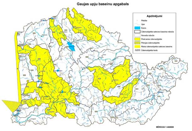
| Designations |
Apzīmējumi |
| Town/city |
Pilsēta |
| River |
Upe |
| Lake |
Ezers |
| Boundary of catchment area of a
water body |
Ūdensobjekta sateces baseina
robeža |
| Border of the municipality |
Novada robeža |
| Coastal water body |
Piekrastes ūdensobjekts |
| Transitional water body |
Pārejas ūdensobjekts |
| Catchment area of a water body
at risk |
Riska ūdensobjekta sateces
baseins |
| Code of a water body |
Ūdensobjekta kods |
| Scale |
Mērogs |
Minister for Environmental Protection
and
Regional Development R.Vējonis
Annex 6
Cabinet
Regulation No. 418
31 May 2011
River Basin
District of Lielupe
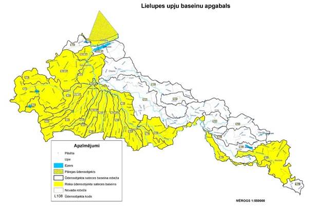
| Designations |
Apzīmējumi |
| Town/city |
Pilsēta |
| River |
Upe |
| Lake |
Ezers |
| Transitional water body |
Pārejas ūdensobjekts |
| Boundary of catchment area of a
water body |
Ūdensobjekta sateces baseina
robeža |
| Catchment area of a water body
at risk |
Riska ūdensobjekta sateces
baseins |
| Border of the municipality |
Novada robeža |
| Code of a water body |
Ūdensobjekta kods |
| Scale |
Mērogs |
Minister for Environmental Protection
and
Regional Development R.Vējonis
Annex 7
Cabinet
Regulation No. 418
31 May 2011
River Basin
District of Venta
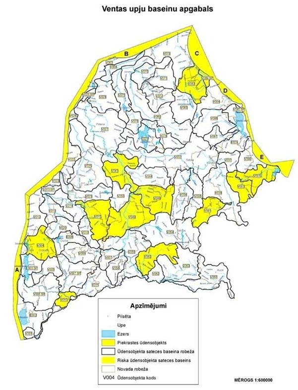
| Designations |
Apzīmējumi |
| Town/city |
Pilsēta |
| River |
Upe |
| Lake |
Ezers |
| Coastal water body |
Piekrastes ūdensobjekts |
| Boundary of catchment area of a
water body |
Ūdensobjekta sateces baseina
robeža |
| Catchment area of a water body
at risk |
Riska ūdensobjekta sateces
baseins |
| Border of the municipality |
Novada robeža |
| Code of a water body |
Ūdensobjekta kods |
| Scale |
Mērogs |
Minister for Environmental Protection
and
Regional Development R.Vējonis
Translation © 2011 Valsts valodas centrs (State
Language Centre)
|
|
Related documents
-
Amendments
-
Issued pursuant to
-
Annotation / draft legal act
|