Section 1.
The Teiči Strict Nature Reserve (hereinafter - the Reserve) is
a specially protected nature territory of State significance
which has been included in the List of Wetlands of International
Importance of the Convention on Wetlands of International
Importance Especially as Waterfowl Habitat of 2 February
1971.
Section 2.
The Reserve has been established for the purpose of preserving
the Teiči bog and the wet forest complex ecologically related
hereto and ensuring the natural development of ecosystems and
biological diversity specific to them.
Section 3.
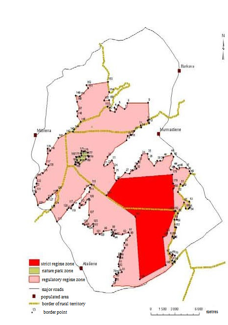
(1) The Reserve has an area of 19 779 hectares and its borders
have been determined in accordance with the Teiči Strict Nature
Reserve plan (Annex 1) and the description of borders of the
Teiči Strict Nature Reserve (Annex 2).
1) the properties bordering on the Reserve have been indicated
in accordance with the information of the Register of State
Immovable Property Cadastre from 2005;
2) the compartment numbers of the State forest in the
territory of the Reserve have been indicated in accordance with
the data of the forest inventory from 2005.
Section 4.
The administration of the Reserve shall be implemented by the
Nature Conservation Agency (hereinafter - the Agency) that is an
institution of direct administration subordinate to the Minister
for Environmental Protection and Regional Development.
Section 5.
The territory of the Reserve shall be divided into the
following functional zones:
3) the nature park zone.
Section 6.
(1) The strict regime zone has been established in order to
ensure natural development of ecosystems that are typical for the
Reserve.
(2) The strict regime zone shall not permit any economic
activity, and also construction of buildings and structures.
(3) Stay in the strict regime zone is prohibited, it may be
visited only with authorisation of the Agency for research and
protection purposes.
Section 7.
(1) The regulatory regime zone has been established in order
to ensure diversity of species and biotopes in the Reserve, to
study the development of ecosystems and their elements, and also
to promote public understanding of the environment under minimal
anthropogenic pressure.
1) stay without a written authorisation of the Agency or the
presence of the employee from the Agency (with the exception of
the persons residing in the territory of the Reserve);
3) carry out forestry activity, except for tree felling for
the establishment and maintenance of the forest infrastructure,
landscaping, removal of dangerous trees, preservation of
biological diversity and the necessary transformation of forest
land referred to in Paragraph three, Clause 2 of this
Section;
4) carry out other economic activity which is in contradiction
to the objectives of establishing the Reserve, the requirements
for the protection of species and biotopes;
5) gather forest non-wood material values, including wild
berries and mushrooms, except for cranberries.
1) implement the necessary nature protection measures and
activities for the preservation and recovery of specially
protected animal species and biotopes;
2) carry out reconstruction of regional and State main roads
and transformation of land necessary for it;
3) maintain and develop the infrastructure for environmental
learning and education in the possession of the Agency,
clearances of forest compartments, and water supply points for
extinguishing fires;
4) implement forest fire-fighting and fire safety measures in
accordance with the plan of preventive measures for forest fire
safety.
(4) It shall be permitted in the regulatory regime zone with a
written authorisation of the Agency to:
1) maintain roads, delimiting boundaries of the Reserve,
electrical power lines, and electronic communications
infrastructure;
2) for residents of the local governments in the territory of
the Reserve, gather cranberries.
Section 8.
(1) The nature park zone has been established in order to
preserve the extensive types of environmental management which
have formed over the course of history and to balance out the
interests of nature protection, environmental education, and
local residents.
5) change the hydrological regime of surface water and
underground water, except where it necessary for the protection
of species and biotopes, preservation or enlargement of
biological diversity;
6) use mineral fertilisers, chemical plant protection
products, and also other dangerous chemical substances and
products outside of yards and gardens;
7) change the natural land relief, damage or destroy landscape
elements of ecological and aesthetic significance;
8) extract mineral resources, except for the extraction of
drinking water for personal use;
9) burn dry grass, leaves, and reeds outside of yards and
gardens, except where it is necessary for carrying out measures
for protection of biotopes;
10) introduce the species of flora and fauna which are foreign
to local conditions in natural habitats.
Section 9.
Bird hunting shall be banned and hunting of specially
protected mammals shall be limited in the territory of the
Reserve. Hunting of other species of mammals in the territory of
the Reserve shall be permissible in accordance with the hunting
district plan.
Section 10.
(1) In order to reduce the economic and anthropogenic impact
on ecosystems, an external protection zone shall be determined
around the Reserve. Its external border goes along the E22-A12
Jēkabpils-Russian border (Terehova) motor road, right of way of
the P62 Krāslava-Madona, P82 Jaunkalsnava-Lubāna and P84
Madona-Varakļāni road, not including villages but the internal
border coincides with the external border of the Reserve.
3) damage or destroy landscape elements of ecological and
aesthetic significance;
5) perform activities that may have a significant negative
impact on the state of specially protected species and biotopes
and the natural development of ecosystems.
(3) It shall be permitted in the external protection zone with
a written authorisation of the Agency to:
4) establish enclosed outdoor nurseries for wild animal
species.
(4) Construction may be performed in the external protection
zone in accordance with the local government spatial plan and the
procedures laid down in the laws and regulations regarding
construction, taking into account the laws and regulations
regarding environmental impact assessment.
Section 11.
Section 12.
Section 13.
Draft spatial plans at all levels concerning the territory of
the Reserve and its external protection zone shall be harmonised
with the Agency.
Section 14.
It is prohibited for natural and legal persons to collect
natural materials for collections, to carry out studies,
measurements, survey, or monitoring, and also to photograph and
film for commercial purposes without a written authorisation of
the Agency.
Section 15.
Section 16.
Section 17.
(1) In order to harmonise the interests of nature protection
and economic activity, the Advisory Council of the Teiči Strict
Nature Reserve (hereinafter - the Council) shall be established
which simultaneously also performs the functions of the Advisory
Council of the Krustkalni Strict Nature Reserve. The Council
shall consist of one representative from local governments that
are located in the territory of the Reserve, the State Forest
Service, the State Environmental Service. The composition of the
Council may include representatives from associations or
foundations by twos the activities of which are related to the
environmental or nature protection and environmental
education.
(2) The Cabinet shall approve the by-laws of the Council.
(3) The personnel of the Council shall be approved by the
Minister for Environmental Protection and Regional
Development.
1. With the coming into force of this Law, the Teiči Strict
Nature Reserve Law (Latvijas Republikas Saeimas un Ministru
Kabineta Ziņotājs, 2000, No. 9) is repealed.
2. The Cabinet shall, by 1 January 2009, issue the regulations
referred to in Section 17, Paragraph two of this Law. Until the
day of coming into force of such regulations, but not later than
until 31 December 2008, Cabinet Regulation No. 259 of 1 August
2000, By-Laws of the Advisory Council of the Teiči Strict Nature
Reserve, shall be applied, insofar as they are not in
contradiction with this Law.
3. Amendments to Annex 2 to this Law regarding harmonisation
of the scheme and description of the borders of the Teiči Strict
Nature Reserve with the Law on Administrative Territories and
Populated Areas shall come into force on 1 July 2009.
4. The Reserve shall be administered by the administration of
the Teiči Strict Nature Reserve until 1 June 2009.
5. Until 1 July 2009, the term "regional motor road" used in
Section 7, Paragraph three, Clause 2 of this Law shall mean the
term "Category 1 motor road" (in the relevant case).
The Law shall come into force on the day following its
proclamation.
President V. Zatlers
1. Description
of the External Border
|
No.
|
Numbers of border sections
according to the plan
|
The situation elements of the
plan according to which the border has been determined
|
|
1
|
2
|
3
|
| 1.1. |
Madona municipality,
Barkava rural territory |
| 1.1.1. |
1-2
|
From the border point of Mētriena and Barkava rural
territories at (the River) Isliena upe due south-west, and
south-east along the border of the property "Teiči" (cadastre
No. 70440070024) to the border of the property "Pulcenes"
(cadastre No. 70440070104) |
| 1.1.2. |
2-3
|
Due south-east along the borders of the properties
"Pulcenes" (cadastre No. 70440070104), "Zaļā Sala" (cadastre
No. 70440070098), and "Pulcenes" (cadastre No. 70440070094)
to the border of the property "Mežsētas" (cadastre No.
70440070070) |
| 1.1.3. |
3-4
|
Due north along the external border of the property
"Mežsētas" (cadastre No. 70440070070) to the north-western
corner of the property "Mežsētas" |
| 1.1.4. |
4-5
|
Due south-east along the external border of the
property "Mežsētas" (cadastre No. 70440070070) to the
northern corner of the property "Pulcenes" (cadastre No.
70440070094) |
| 1.1.5. |
5-6
|
Due north-east along the border of the property
"Pulcenes" (cadastre No. 70440070094) to the border of the
property "Smiltnieki" (cadastre No. 70440070095) |
| 1.1.6. |
6-7
|
Due south-east along the borders of the properties
"Smiltnieki" (cadastre No. 70440070095) and "Vecpulcenes"
(cadastre No. 70440070043) to the south-eastern corner of the
property "Vecpulcenes" |
| 1.1.7. |
7-8
|
Due north-east along the border of the property
"Vecpulcenes" (cadastre No. 70440070043) to the border of the
State forest (cadastre No. 70440070068) in the possession of
the Ministry of Agriculture |
| 1.1.8. |
8-9
|
Due east along the southern
border of the State forest (cadastre No. 70440070068) in the
possession of the Ministry of Agriculture to the corner of
the forest compartment 207 |
| 1.1.9. |
9-10
|
Due south along the western
border of the State forest (cadastre No. 70440070068) in the
possession of the Ministry of Agriculture to border of the
property "Jaunsudrabiņi" (cadastre No. 70780030273) (it
coincides with the border of Barkava un Murmastiene rural
territories) |
| 1.2. |
Varakļāni
municipality, Murmastiene rural territory |
| 1.2.1. |
10-11
|
Due south-east along the
border of the property "Jaunsudrabiņi" (cadastre No.
70780030273) to the eastern border of this property |
| 1.2.2. |
11-12
|
Due south-east along the
borders of the properties "Jaunsudrabiņi" (cadastre No.
70780030273) and "Birztalas" (cadastre No. 70780030133) to
the border of the property with cadastre No. 70780030286 |
| 1.2.3. |
12-13
|
Due south-west along the
borders of the property with cadastre No. 70780030286,
70780030046, properties "Jaunarāji" (cadastre No.
70780030229), "Skangaļi" (cadastre No. 70780030137), "Lāči"
(cadastre No. 70780030107), and "Rozītes" (cadastre No.
70780030171) to the north-western corner of the property
"Rozītes" |
| 1.2.4. |
13-14
|
Due south-east along the
border of the property "Rozītes" (cadastre No. 70780030171)
to the border of the property "Vaivari" (cadastre No.
70780030007) |
| 1.2.5. |
14-15
|
Due west and south-west along
the amelioration ditch "Grāna grāvis" and the borders of the
properties "Vaivari" (cadastre No. 70780030007), "Kastaņi"
(cadastre No. 70780030042), "Ābeles" (cadastre No.
70780030245), and "Jaunarāji" (cadastre No. 70780030132) to
the border point of Barkava and Murmastiene rural territories
on the border of the property "Jaunarāji" |
| 1.2.6. |
15-16
|
From the border point of
Barkava and Murmastiene rural territories due south-west
along the amelioration ditch "Grāna grāvis" and the borders
of the properties "Jaunarāji" (cadastre No. 70780030132),
"Pūkas" (cadastre No. 70780030086), "Laimiņi" (cadastre No.
70780030023), and "Skangaļi" (cadastre No. 70780030136) to
the border of the property "Vētras" (cadastre No.
70780030152) |
| 1.2.7. |
16-17
|
Due north-west and south-west
along the border of the property "Vētras" (cadastre No.
70780030152) to the border of the property (cadastre No.
70780030212) |
| 1.2.8. |
17-18
|
Due south-west and west along
the border of the property "Mežmaļi" (cadastre No.
70780030212) to the border of the property "Jaunarāji"
(cadastre No. 70780030131) |
| 1.2.9. |
18-19
|
Due south-west, south-east,
and south-west along the border of the property "Jaunarāji"
(cadastre No. 70780030131) to the border of the property
"Līvlandi" (cadastre No. 70780030278) |
| 1.2.10. |
19-20
|
Due south-west along the borders
of the properties "Līvlandi" (cadastre No. 70780030278),
"Avoti" (cadastre No. 70780030081), "Iecelnieki" (cadastre
No. 70780030277), "Avotiņi" (cadastre No. 70780030175),
"Kļavinieki" (cadastre No. 70780030002), "Kolneji" (cadastre
No. 70780030032), "Blisiņi" (cadastre No. 70780030272), "Jāņu
mājas" (cadastre No. 7078003121), "Ābeles" (cadastre No.
70780030113), "Silzemes" (cadastre No. 70780030066), "Irbes"
(cadastre No. 7078003004), "Virši" (cadastre No.
70780030006), "Eglinieki" (cadastre No. 70780030077),
"Ceriņi1" (cadastre No. 70780030108), and "Tolkāja" (cadastre
No. 70780030016) to the Murmastiene-Silagals local government
road (cadastre No. 70780030201) |
| 1.2.11. |
20-21
|
Crossing the
Murmastiene-Silagals local government road (cadastre No.
70780030201) due south along the border of the property
"Tolkāja" (cadastre No. 70780030017) to the border of the
property "Skangaļi" (cadastre No. 70780030182) |
| 1.2.12. |
21-22
|
Due south and north-east
along the border of the property "Skangaļi" (cadastre No.
70780030182) to the border of the property "Ābeles" (cadastre
No. 70780030181) |
| 1.2.13. |
22-23
|
Due north-east along the
borders of the properties "Ābeles" (cadastre No. 70780030181)
and "Smilgas" (cadastre No. 70780030221) to the border of the
property "Liepas" (cadastre No. 70780030270) |
| 1.2.14. |
23-24
|
Due south-east along the
borders of the properties "Liepas" (cadastre No.
70780030270), "Ābeles" (cadastre No. 70780030242), "Ozoliņi"
(cadastre No. 70780030213), and "Ābeles" (cadastre No.
70780030242) to the border of the property "Pārupes"
(cadastre No. 7078003122) |
| 1.2.15. |
24-25
|
Due south and south-east
along the border of the property "Pārupes" (cadastre No.
7078003122) to the border of the property "Vilkates"
(cadastre No. 70780030018) |
| 1.2.16. |
25-26
|
Due south along the border of
the property "Vilkates" (cadastre No. 70780030018) further
due south-east along the border of the property "Vērstiņsala"
(cadastre No. 70780030044) to the southern corner of this
property |
| 1.2.17. |
26-27
|
From the southern corner of
the property "Vērstiņsala" (cadastre No. 70780030044) due
north-east along the borders of the properties "Vērstiņsala"
(cadastre No. 70780030044), "Vērstiņsala-1" (cadastre No.
70780030198), "Jāņu mājas" (cadastre No. 70780030240) to the
south-western corner of the property "Čopmaļi" (cadastre No.
70780030238) |
| 1.2.18. |
27-28
|
From the south-western corner
of the property "Čopmaļi" (cadastre No. 70780030238) due east
along the borders of the properties "Čopmaļi", "Pīlādži"
(cadastre No. 70780030239), "Pūriņi" (cadastre No.
70780030235), and "Ošlejas" (cadastre No. 70780030014) to the
southern corner of the property "Ošlejas" |
| 1.2.19. |
28-29
|
From the southern corner of
the property "Ošlejas" (cadastre No. 70780030014) due
north-east and east along the border of this property to the
south-western corner of the property "Brūklenāji" (cadastre
No. 70780030251) |
| 1.2.20. |
29-30
|
From the south-western corner
of the property "Brūklenāji" (cadastre No. 70780030251) due
north-east along the borders of the properties "Brūklenāji"
and "Kapteiņi" (cadastre No. 70780030236) to (the River)
Dirītes upe |
| 1.2.21. |
30-31
|
Due north-west along the
borders of the properties "Kapteiņi" (cadastre No.
70780030236) and "Paegļi" (cadastre No. 70780030039) and (the
River) Dirītes upe to the border of the property "Kalnlapsas"
(cadastre No. 70780040184) |
| 1.2.22. |
31-32
|
Due north-east along the
borders of the properties "Kalnlapsas" (cadastre No.
70780040184) and "Zemzari" (cadastre No. 70780040098) to the
border of the property "Leimaņi" (cadastre No.
70780040186) |
| 1.2.23. |
32-33
|
Due south-east and north-east
along the border of the property "Leimaņi" (cadastre No.
70780040186) to the border of the property "Rozes" (cadastre
No. 70780040245) |
| 1.2.24. |
33-34
|
Due north-east along the
border of the property "Rozes" (cadastre No. 70780040245) to
the border of the property "Tumaši" (cadastre No.
70780040160) |
| 1.2.25. |
34-35
|
Due north-east and east along
the border of the property "Tumaši" (cadastre No.
70780040160) to the border of the property "Kokāji" (cadastre
No. 70780040274) |
| 1.2.26. |
35-36
|
Due south and south-east
along the borders of the properties "Kokāji" (cadastre No.
70780040274), "Tropi" (cadastre No. 70780040247), and "Rutki"
(cadastre No. 70780040174) to the border of the property
"Ziemeļi" (cadastre No. 70780040170) |
| 1.2.27. |
36-37
|
Due south-west and south-east
along (the River) Lisiņas upe and the borders of the
properties Ziemeļi" (cadastre No. 70780040170), "Liepas"
(cadastre No. 70780040401), "Strautiņi" (cadastre No.
70780040219), and "Pīlādzīši" (cadastre No. 70780040234) to
the southern corner of the property "Pīlādzīši" |
| 1.2.28. |
37-38
|
Due north-east along (the
River) Lisiņas upe and the borders of the properties
"Pīlādzīši" (cadastre No. 70780040234) and "Zīles" (cadastre
No. 70780040031) to the border of the property "Viktorīši"
(cadastre No. 70780040211) |
| 1.2.29. |
38-39
|
Due east along the border of
the property "Viktorīši" (cadastre No. 70780040211) to the
border of the property "Rutki" (cadastre No.
70780040335) |
| 1.2.30. |
39-40
|
Due south-east and north-east
along the border of the property "Rutki" (cadastre No.
70780040335) to the border of the property "Krūkļi" (cadastre
No. 70780040189) |
| 1.2.31. |
40-41
|
Due north-east and north
along the amelioration ditch and the borders of the
properties "Krūkļi" (cadastre No. 70780040189), "Jakubāni"
(cadastre No. 70780040059), and "Rāceņi" (cadastre No.
70780040019) to the border of the property "Mālnieki"
(cadastre No. 70780040034) |
| 1.2.32. |
41-42
|
Due south-east along the
amelioration ditch and the borders of the properties
Mālnieki" (cadastre No. 70780040034) and "Jaunavas" (cadastre
No. 70780040136) to the border of the property "Sarkaņi"
(cadastre No. 70780040055) |
| 1.2.33. |
42-43
|
Due south along the
amelioration ditch and the borders of the properties
"Sarkaņi" (cadastre No. 70780040055), "Vālodzītes" (cadastre
No. 70780040051), "Dravnieki" (cadastre No. 70780040176), and
"Skariņi" (cadastre No. 70780040083) to the border of the
property "Broki" (cadastre No. 70780040089) |
| 1.2.34. |
43-44
|
Due east and north-east along
the amelioration ditch and the border of the property "Broki"
(cadastre No. 70780040089) to the border of the property
"Skariņi" (cadastre No. 70780040082) |
| 1.2.35. |
44-45
|
Due south-east along the
amelioration ditch and the border of the property "Skariņi"
(cadastre No. 70780040082) to the border of the property
"Broki" (cadastre No. 70780040090) |
| 1.2.36. |
45-46
|
Due south-east, east, and
north along the border of the property "Broki" (cadastre No.
70780040090) to the Veipi-Tiltagals local government road
(cadastre No. 70780040278) |
| 1.2.37. |
46-47
|
Uz austrumiem gar pašvaldības
ceļu Veipi-Tiltagals (kadastra Nr.70780040278) līdz īpašuma
"Priedaine" (kadastra Nr.70780080055) robežai |
| 1.2.38. |
47-48
|
Due south-east, east, and
south-east along the border of the property "Priedaine"
(cadastre No. 70780080055) to the border of the property
"Gredzentiņi" (cadastre No. 70780080103) |
| 1.2.39. |
48-49
|
Due south-east along the
border of the property "Gredzentiņi" (cadastre No.
70780080103) to the border of the property "Pekši" (cadastre
No. 70940020230) (it coincides with the border of Murmastiene
un Varakļāni rural territories) |
| 1.3. |
Varakļāni
municipality, Varakļāni rural territory |
| 1.3.1. |
49-50
|
Due south-west along the
borders of the properties "Pekši" (cadastre No. 70940020230),
"Piekalnes" (cadastre No. 70940020022), "Pelši" (cadastre No.
70940020044), "Lejaspļava" (cadastre No. 70940020050),
"Ozolpļava" (cadastre No. 70940020254), "Čeičinieki"
(cadastre No. 70940020018), "Lapu mājas" (cadastre No.
70940020054), "Aizupes" (cadastre No. 70940020027), "Ogu
sala" (cadastre No. 70940020045), and "Odiņi" (cadastre No.
70940020180) to the border of the property "Elki" (cadastre
No. 70940020063) |
| 1.3.2. |
50-51
|
Due north-west along the
border of the property "Elki" (cadastre No. 70940020063) to
the northern corner of this property |
| 1.3.3. |
51-52
|
Due south-west along the
borders of the properties "Elki" (cadastre No. 70940020063),
"Priežusalas" (cadastre No. 70940020025), and "Salas"
(cadastre No. 70940020066) to the south-western corner of the
property "Salas" |
| 1.3.4. |
52-53
|
Due south-east along the
borders of the properties "Salas" (cadastre No. 70940020066),
"Tiltnieki" (cadastre No. 70940020068), "Ieviņas" (cadastre
No. 70940020222), "Madaras" (cadastre No. 70940020219),
"Dzērvītes" (cadastre No. 70940020040), and "Zaļmeži Plus"
(cadastre No. 70940020164) to the border of the property
"Ozoliņi" (cadastre No. 70940020181) |
| 1.3.5. |
53-54
|
Due south along the borders
of the property "Ozoliņi" (cadastre No. 70940020181), "Teiči"
(cadastre No. 70940020131), "Lauciņi" (cadastre No.
70940020260) to the border of the property "Mežrozītes"
(cadastre No. 70940050040) |
| 1.3.6. |
54-55
|
Due south-west along the
border of the property "Mežrozītes" (cadastre No.
70940050040) to the border of the property "Ceļinieki"
(cadastre No. 70940050037) |
| 1.3.7. |
55-56
|
Due west along the borders of
the properties "Ceļinieki" (cadastre No. 70940050037) and
"Ecīši" (cadastre No. 70940050154) to the border of the
property "Jaunecīši" (cadastre No. 70940050108) |
| 1.3.8. |
56-57
|
Due north along the border of
the property "Jaunecīši" (cadastre No. 70940050108) to the
northern corner of this property at (the River) Teicijas
upe |
| 1.3.9. |
57-58
|
Due south-west along (the
River) Teicijas upe and the borders of the properties
Jaunecīši" (cadastre No. 70940050108), "Anemones" (cadastre
No. 70940050196), "Dzeduļi" (cadastre No. 70940050197), and
"Smaidas" (cadastre No. 70940050049) to the border of the
property "Ērgļi" (cadastre No. 70940060239) |
| 1.3.10. |
58-59
|
Due south-west and south
along (the River) Teicijas upe and the external eastern
borders of the properties "Ērgļi" (cadastre No. 70940060239),
"Atvases" (cadastre No. 709400600332) and "Laimiņi" (cadastre
No. 70940060132) to the border of the property "Salas"
(cadastre No. 70940060222) |
| 1.3.11. |
59-60
|
Due west along the border of
the property "Salas" (cadastre No. 70940060222) to the
north-western corner of this property |
| 1.3.12. |
60-61
|
Due south along the western
borders of the properties "Mežvītoli" (cadastre No.
70940060223), "Ieviņas" (cadastre No. 70940060137), "Tālava"
(cadastre No. 70940060144), and "Ozoli" (cadastre No.
70940060063) to the south-western corner of the property
"Ozoli" |
| 1.3.13. |
61-62
|
Due east along the border of
the property "Ozoli" (cadastre No. 70940060063) to the border
of the property "Vālodzītes" (cadastre No. 70940060231) |
| 1.3.14. |
62-63
|
Due south-west along the
borders of the properties "Vālodzītes" (cadastre No.
70940060231) and "Mežlīči" (cadastre No. 70940060134) to the
border of the property "Līgo 2" (cadastre No.
70940060146) |
| 1.3.15. |
63-64
|
Due south-east along the
external border of the property "Līgo 2" (cadastre No.
70940060146) to the south-eastern corner of this
property |
| 1.3.16. |
64-65
|
Due south-west along the
external border of the property "Līgo 2" (cadastre No.
70940060146) to the southern corner of this property |
| 1.3.17. |
65-66
|
Due north-west along the
external border of the property "Līgo 2" (cadastre No.
70940060146) to the western corner of this property |
| 1.3.18. |
66-67
|
Due south and south-west
along the western borders of the properties "Lielie
Ciematnieki" (cadastre No. 70940060036), "Vējavas" (cadastre
No. 70940060330), "Silakalns" (cadastre No. 70940060313),
"Zvīdriņi" (cadastre No. 70940060226), and "Ceriņi" (cadastre
No. 70940060145) to the border of the property "Skangaļi"
(cadastre No. 70940060031) |
| 1.3.19. |
67-68
|
Due south-east along the
borders of the properties "Skangaļi" (cadastre No.
70940060031) and "Jaungribolva" (cadastre No. 70940060265) to
the border of the property "Purvs" (cadastre No.
70940060264) |
| 1.3.20. |
68-69
|
Due north-east along the
external border of the property "Purvs" (cadastre No.
70940060264) to the northern corner of this property |
| 1.3.21. |
69-70
|
Due south-east along the
external border of the property "Purvs" (cadastre No.
70940060264) to the eastern corner of this property |
| 1.3.22. |
70-71
|
Due south-west along the
external border of the property "Purvs" (cadastre No.
70940060264) to the border of the property "Upītes" (cadastre
No. 70940060308) |
| 1.3.23. |
71-72
|
Due south and south-east
along the borders of the properties "Upītes" (cadastre No.
70940060308) and "Ieviņas" (cadastre No. 70940060298) to the
north-western side of the A12 Jēkabpils-Rēzekne State motor
road (cadastre No. 70940060287) further crossing the
above-mentioned motor road in south-eastern direction |
| 1.3.24. |
72-73
|
Due north-east along the
south-eastern side of the A12 Jēkabpils-Rēzekne State motor
road (cadastre No. 70940060287) to the turning point in a
south-eastern direction |
| 1.3.25. |
73-74
|
Due south-east to the
Rīga-Zilupe rail line (cadastre No. 56460070002) |
| 1.4. |
Krustpils
municipality, Atašienes rural territory |
| 1.4.1. |
74-75
|
Due south-west and west along
the Rīga-Zilupe rail line (cadastre No. 56460070002) to the
border of the property "Caunas" (cadastre No.
56460060265) |
| 1.4.2. |
75-76
|
Due north-east, east, and
north-east along the amelioration ditch and the border of the
property "Caunas" (cadastre No. 56460060265) to the border of
the property "Zaļumi" (cadastre No. 56460060143) |
| 1.4.3. |
76-77
|
Due north-east along the
border of the property "Zaļumi" (cadastre No. 56460060143) to
the border of the property "Gārgale" (cadastre No.
56460060145) |
| 1.4.4. |
77-78
|
Due north-west, north, and
north-east along the amelioration ditch and the external
border of the property "Gārgale" (cadastre No. 56460060145)
to the north-western corner of this property |
| 1.4.5. |
78-79
|
Due south-east along the
external border of the property "Gārgale" (cadastre No.
56460060145) to the border of the property "Bērzaine"
(cadastre No. 56460060114) |
| 1.4.6. |
79-80
|
Due north-east along the
border of the property "Bērzaine" (cadastre No. 56460060114)
to the border of the property "Avotiņi" (cadastre No.
56460060056) |
| 1.4.7. |
80-81
|
Due north-east along the
border of the property "Avotiņi" (cadastre No. 56460060056)
to the eastern corner of the property |
| 1.4.8. |
81-82
|
Due north-west along the
border of the property "Avotiņi" (cadastre No. 56460060056)
to the border of the property "Brokas" (cadastre No.
56460060100) |
| 1.4.9. |
82-83
|
Due north-east and north-west
along the border of the property "Brokas" (cadastre No.
56460060100) to the border of the property "Jaunborovka"
(cadastre No. 56460060040) |
| 1.4.10. |
83-84
|
Due north-east along the
borders of the properties "Jaunborovka" (cadastre No.
56460060040) and "Brokas" (cadastre No. 56460060138) and
"Jaunborovka" (cadastre No. 56460060041) to the border of the
property "Purva Strazdi" (cadastre No. 56460060374) |
| 1.4.11. |
84-85
|
Due north-west along the
external border of the property "Purva Strazdi" (cadastre No.
56460060374) to the south-western corner of this
property |
| 1.4.12. |
85-86
|
Due north-east, south-east,
and north-east along the external border of the property
"Purva Strazdi" (cadastre No. 56460060374) to the border of
the property "Bitenieki" (cadastre No. 56460050044) |
| 1.4.13. |
86-87
|
Due north-east along the
border of the property "Bitenieki" (cadastre No. 56460050044)
to the border of the property "Kaķīši" (cadastre No.
56460050043) |
| 1.4.14. |
87-88
|
Due north-east along the
borders of the properties "Kaķīši" (cadastre No.
56460050043), "Bitenieki" (cadastre No. 56460050044), and
"Elenengofa" (cadastre No. 56460050003) to the eastern corner
of the property "Elenengofa" (cadastre No. 56460050003) |
| 1.4.15. |
88-89
|
Due north-west and north-east
along the border of the property "Elenengofa" (cadastre No.
56460050003) to the border of the property "Bitītes"
(cadastre No. 56460050015) |
| 1.4.16. |
89-90
|
Due north-east along the
border of the property "Bitītes" (cadastre No. 56460050015)
to the border of the property "Lapas" (cadastre No.
56460050052) |
| 1.4.17. |
90-91
|
Due north along the external
western border of the property "Lapas" (cadastre No.
56460050052) to the border of the property "Bitītes"
(cadastre No. 56460050015) |
| 1.4.18. |
91-92
|
Due west along the borders of
the properties "Bitītes" (cadastre No. 56460050015),
"Priedītes" (cadastre No. 56460050042), and "Bitītes"
(cadastre No. 56460050015) to the border of the property
"Birzītes" (cadastre No. 56460050033) |
| 1.4.19. |
92-93
|
Due west along the border of
the property "Birzītes" (cadastre No. 56460050033) to the
border of the property "Priedītes" (cadastre No.
56460050042) |
| 1.4.20. |
93-94
|
Due south along the border of
the property "Priedītes" (cadastre No. 56460050042) to the
border of the property "Vecstutka" (cadastre No.
56460050032) |
| 1.4.21. |
94-95
|
Due west along the border of
the property "Vecstutka" (cadastre No. 56460050032) to the
border of the property "Meldri" (cadastre No.
56460050064) |
| 1.4.22. |
95-96
|
Due north-east along the
borders of the properties "Meldri" (cadastre No. 56460050064)
and "Lejiņas" (cadastre No. 56460050050) to the border of the
property "Ozolkalns" (cadastre No. 56460050009) |
| 1.4.23. |
96-97
|
Due north-east and north-west
along the border of the property "Ozolkalns" (cadastre No.
56460050009) to the border of the local government land
(cadastre No. 56460050013) |
| 1.4.24. |
97-98
|
Due north-west along the
local government land (cadastre No. 56460050013) to the
border of the property "Lejiņas" (cadastre No.
56460050050) |
| 1.4.25. |
98-99
|
Due west along the borders of
the properties "Lejiņas" (cadastre No. 56460050050), Meldri"
(cadastre No. 56460050001) to the border of the property
"Ezernīca" (cadastre No. 56460040053) |
| 1.4.26. |
99-100
|
Due west and south-west along
the border of the property "Ezernīca" (cadastre No.
56460040053) to the southern corner of the land unit of the
property Ezernīca" (cadastre No. 56460020053) [it coincides
with the border of the property "Vīnogas" (cadastre No.
56460040054)] |
| 1.4.27. |
100-101
|
Due north-west, west, and
south-west along the border of the property "Vīnogas"
(cadastre No. 56460040054) to the border of the property
"Dzendegļi" (cadastre No. 56460020039) |
| 1.4.28. |
101-102
|
Due west, north-west, and
north along the border of the property "Dzendegļi" (cadastre
No. 56460020039) to the border of the property "Jaunābeļi"
(cadastre No. 56460020040) |
| 1.4.29. |
102-103
|
Due north along the borders
of the properties "Jaunābeļi" (cadastre No. 56460020040) and
"Eiduki" (cadastre No. 56460020031) to the north-eastern
corner of the property "Eiduki" |
| 1.4.30. |
103-104
|
Due south-west along the
borders of the properties "Eiduki" (cadastre No.
56460020031), "Strīķi" (cadastre No. 56460020018), and
"Dzendegļi" (cadastre No. 56460020008) to the border of the
property "Zeltiņi" (cadastre No. 56460020003) |
| 1.4.31. |
104-105
|
Due north and west along the
border of the property "Zeltiņi" (cadastre No. 56460020003)
to the border of the property "Martas kalns" (cadastre No.
56460020007) |
| 1.4.32. |
105-106
|
Due north-west and west along
the borders of the properties "Martas kalns" (cadastre No.
56460020007) and "Ziediņi" (cadastre No. 56460020005) to the
border of the property "Ķieģeļi" (cadastre No.
56460020010) |
| 1.4.33. |
106-107
|
Due north-east and north
along the border of the property "Ķieģeļi" (cadastre No.
56460020010) to the border of the property "Drivnieki"
(cadastre No. 56460020001) |
| 1.4.34. |
107-108
|
Due north along the borders
of the properties "Drivnieki" (cadastre No. 56460020001),
"Zālāni" (cadastre No. 56460020011), "Lejas" (cadastre No.
56460020004), and "Gundegas" (cadastre No. 56460020033) to
the north-eastern corner of the property "Gundegas" |
| 1.4.35. |
108-109
|
Due west and south-west along
the border of the property "Gundegas" (cadastre No.
56460020033) to the border of the property "Senči" (cadastre
No. 56460020032) |
| 1.4.36. |
109-110
|
Due south-west, north-west,
and south-west along the border of the property "Senči"
(cadastre No. 56460020032) to the border of the property
"Līņi" (cadastre No. 56460010017) |
| 1.4.37. |
110-111
|
Due south-west, south, and
north-west along the border of the property "Līņi" (cadastre
No. 56460010017) to the border of the property "Eiduku purvs"
(cadastre No. 56460010027) |
| 1.4.38. |
111-112
|
Due north-west and north-east
along the border of the property "Eiduku purvs" (cadastre No.
56460010027) to the border of the property "Gundegas"
(cadastre No. 56460010028) |
| 1.4.39. |
112-113
|
Due north-east, east, and
north-east along the border of the property "Gundegas"
(cadastre No. 56460010028) to the border of the property
"Auči" (cadastre No. 56460010011) |
| 1.4.40. |
113-114
|
Due north-east along the
border of the property "Auči" (cadastre No. 56460010011) to
the border of the property "Birņi" (cadastre No.
56460010014) |
| 1.4.41. |
114-115
|
Due north-east and north-west
along the border of the property "Birņi" (cadastre No.
56460010014) to the border of the property "Zītari" (cadastre
No. 56460010023) |
| 1.4.42. |
115-116
|
Due south-west along the
border of the property "Zītari" (cadastre No. 56460010023) to
the border of the property "Gundegas" (cadastre No.
56460010028) |
| 1.4.43. |
116-117
|
Due south-west along the
border of the property "Gundegas" (cadastre No. 56460010028)
to the border of the property "Eiduki" (cadastre No.
56460010005) |
| 1.4.44. |
117-118
|
Due south-west along the
border of the property "Eiduki" (cadastre No. 56460010005) to
the border of the property "Ezeriņi" (cadastre No.
56460010001) |
| 1.4.45. |
118-119
|
Due south-west, south, and
south-west along the border of the property "Ezeriņi"
(cadastre No. 56460010001) to the border of the property
"Krusti" (cadastre No. 56460010015) |
| 1.4.46. |
119-120
|
Due north-west and south-west
along the border of the property "Krusti" (cadastre No.
56460010015) to the border of the property "Spilves"
(cadastre No. 56460010031) |
| 1.4.47. |
120-121
|
Due west and south-west along
the border of the property "Spilves" (cadastre No.
56460010031) to the border of the property "Apses" (cadastre
No. 56460010006) |
| 1.4.48. |
121-122
|
Due south-west along the
borders of the properties "Apses" (cadastre No. 56460010006),
"Pūriņi" (cadastre No. 56460010008), "Gundegas" (cadastre No.
56460030012), "Vecavotiņi" (cadastre No. 56460030099),
"Miķelāni" (cadastre No. 56460030057), "Miezīši" (cadastre
No. 56460030034), "Janči" (cadastre No. 56460030064), "Senči"
(cadastre No. 5646003000106), and "Jaunalejas" (cadastre No.
56460030019) to the P62 Mētriena-Atašiene State motor road
(cadastre No. 70760110046) |
| 1.4.49. |
122-123
|
Due north-west along the
north-eastern side of the P62 Mētriena-Atašiene State motor
road (cadastre No. 70760110046) to the border of the property
"Austriņi" (cadastre No. 70760110032) |
| 1.4.50. |
123-124
|
Due north-east along the
borders of the properties "Austriņi" (cadastre No.
70760110032) and "Jaunāres" (cadastre No. 70760110015) to the
border point of Atašiene and Mētriena rural territories |
| 1.5. |
Madona municipality,
Mētriena rural territory |
| 1.5.1. |
124-125
|
Due north along the eastern
borders of the properties "Jaunāres" (cadastre No.
70760110015) and "Jaunrāksalas" (cadastre No. 70760110007) to
the border of the property "Jaunrāksalas 2" (cadastre No.
70760110008) |
| 1.5.2. |
125-126
|
Due south-west along the
external south-eastern border of the property "Jaunrāksalas
2" (cadastre No. 70760110008) to the border of the property
"Jaunāres" (cadastre No. 70760110015) |
| 1.5.3. |
126-127
|
Due south-west along the
borders of the properties "Jaunāres" (cadastre No.
70760110015) and "Labumi" (cadastre No. 70760110017) to the
border of the property "Kārkli" (cadastre No.
70760110047) |
| 1.5.4. |
127-128
|
Due south, south-west, and
north-west along the external border of the property "Kārkli"
(cadastre No. 70760110047) to the border of the property
"Pakaļni" (cadastre No. 70760110012) |
| 1.5.5. |
128-129
|
Due south-west along the
borders of the properties "Pakaļni" (cadastre No.
70760110012) and "Labumi" (cadastre No. 70760110017) to the
border of the P62 Mētriena-Atašiene State motor road
(cadastre No. 70760110046) |
| 1.5.6. |
129-130
|
Due north-west along the
north-eastern side of the P62 Mētriena-Atašiene State motor
road (cadastre No. 70760110046) to the border of the property
"Ļūmāni" (cadastre No. 70760090040) |
| 1.5.7. |
130-131
|
Due north-east along the
border of the property "Ļūmāni" (cadastre No. 70760090040) to
the eastern corner of this property |
| 1.5.8. |
131-132
|
Due north-west along the
borders of the properties "Ļūmāni" (cadastre No.
70760090040), "Silgali" (cadastre No. 70760090049), and
"Amati" (cadastre No. 70760090051) to the border of the
property "Mētriņas 2" (cadastre No. 70760090058) |
| 1.5.9. |
132-133
|
Due north-east and north-west
along the external border of the property "Mētriņas 2"
(cadastre No. 70760090058) to the external border of the
property "Medņuriests 2" (cadastre No. 70760090092) |
| 1.5.10. |
133-134
|
Due north along the external
borders of the properties "Medņuriests 2" (cadastre No.
70760090092) and "Lejasrubeņi 2" (cadastre No. 70760090127)
to the border of the property "Šūmāni 2" (cadastre No.
70760090125) |
| 1.5.11. |
134-135
|
Due north-east and south-east
along the external borders of the properties "Šūmāni 2"
(cadastre No. 70760090125) and "Priedes" (cadastre No.
70760090064) to the border of the property "Rubeņi" (cadastre
No. 70760090034) |
| 1.5.12. |
135-136
|
Due north-east along the
border of the property "Rubeņi" (cadastre No. 70760090034) to
the eastern corner of this property |
| 1.5.13. |
136-137
|
Due north-west along the
border of the property "Rubeņi" (cadastre No. 70760090034) to
the border of the property "Melderkalns" (cadastre No.
70760090008) |
| 1.5.14. |
137-138
|
Due north along the borders
of the properties "Melderkalns" (cadastre No. 70760090008)
and "Dzērvītes" (cadastre No. 70760090037) to the border of
the property "Pilskalni 2" (cadastre No. 70760080437) |
| 1.5.15. |
138-139
|
Due north-west and north
along the external border of the property "Pilskalni 2"
(cadastre No. 70760080437) to the border of the property
"Tīrumnieki 2" (cadastre No. 70760080436) |
| 1.5.16. |
139-140
|
Due north-east, south-east,
and south along the external border of the property
"Tīrumnieki 2" (cadastre No. 70760080436) to the border of
the property "Tīrumnieki" (cadastre No. 70760080059) |
| 1.5.17. |
140-141
|
Due north-east along the
border of the property "Tīrumnieki" (cadastre No.
70760080059) crossing the Ozolkalns-Sildi local government
road (cadastre No. 70760080350) further along the borders of
the properties "Priežukalns" (cadastre No. 70760080058),
"Stūrīši" (cadastre No. 70760080400), "Saulgrieži" (cadastre
No. 70760080177), "Valtersala" cadastre No. 70760080381), and
"Sanitas" (cadastre No. 70760060032) to the border of the
property "Gravāni" (cadastre No. 70760060027) |
| 1.5.18. |
141-142
|
Due north-east along the
borders of the properties "Gravāni" (cadastre No.
70760060027), "Dūkstupieši" (cadastre No. 70760060023),
"Purmalas" (cadastre No. 70760060011) to the border of the
property "Isliena" (cadastre No. 70760060047) |
| 1.5.19. |
142-143
|
Due east along the southern
border of the property "Isliena" (cadastre No. 70760060047)
to the south-eastern corner of this property (it coincides
with the border point of Mētriena and Barkava rural
territories) |
| 1.5.20. |
143-144
|
Due north-east along the
border of the property "Isliena" (cadastre No. 70760060047)
to the border of the property "Lazdiņas" (cadastre No.
70760060041) |
| 1.5.21. |
144-145
|
Due north-east along the
borders of the properties "Lazdiņas" (cadastre No.
70760060041), "Kļavēni" cadastre No. 70760060046), "Rozes"
(cadastre No. 70760060007), and "Slokas" (cadastre No.
70760060040) to the eastern corner of the property
"Slokas" |
| 1.5.22. |
145-146
|
Due north-west along the
borders of the property "Slokas" (cadastre No. 70760060040),
"Virši" (cadastre No. 70760060045), un "Bērzi" (cadastre No.
70760060039) to the border of the property "Prausala"
(cadastre No. 70760060029) |
| 1.5.23. |
146-147
|
Due north along the borders
of the properties "Prausala" (cadastre No. 70760060029) and
"Medņuriests" (cadastre No. 70760060015) to the border of the
property "Mazleiši" (cadastre No. 70760060119) |
| 1.5.24. |
147-148
|
Due north-east and north-west
along the border of the property "Mazleiši" (cadastre No.
70760060119) to the border of the property "Jaunrozes"
(cadastre No. 70760060005) |
| 1.5.25. |
148-149
|
Due north-west along the
borders of the properties "Jaunrozes" (cadastre No.
70760060005) and "Celmiņi" (cadastre No. 70760060009) to the
border of the property "Bākšāni" (cadastre No.
70760020110) |
| 1.5.26. |
149-150
|
Due east along the borders of
the properties "Bākšāni" (cadastre No. 70760020110) and
"Ritas" (cadastre No. 70760020094) to the southern corner of
the property "Ritas" |
| 1.5.27. |
150-151
|
Due north-east along the
borders of the properties "Ritas" (cadastre No. 70760020094)
and "Bākšāni" (cadastre No. 70760020118) to the eastern
corner of the property "Bākšāni" |
| 1.5.28. |
151-152
|
Due north-west along the
borders of the properties "Bākšāni" (cadastre No.
70760020118) and "Ritas" (cadastre No. 70760020094) to the
south-western corner of the State forest in the possession of
the Ministry of Agriculture (cadastre No. 70760030027) |
| 1.5.29. |
152-153
|
Due east along the southern
border of the State forest in the possession of the Ministry
of Agriculture (cadastre No. 70760030027) to the border of
the property "Lapsukalns" (cadastre No. 70440010039) (it
coincides with the border point of Mētriena and Barkava rural
territories) |
| 1.5.30. |
153-154
|
Due south along the border of
the property "Lapsukalns" (cadastre No. 70440010039), the
western border of the State forest in the possession of the
Ministry of Agriculture (cadastre No. 70760030027), and the
borders of the properties "Jānīši" (cadastre No. 70440060010)
and "Apsala" (cadastre No. 70440060073) to the border of the
local government property "Apsala" (cadastre No. 70760070004)
(it coincides with the border point of Mētriena and Barkava
rural territories) |
| 1.5.31. |
154-155
|
Due south-west along the
border of the local government property "Apsala" (cadastre
No. 70760070004) to the western corner of the above-mentioned
property |
| 1.5.32. |
155-156
|
Due east along the
amelioration ditch and the border of the property "Apsala"
(cadastre No. 70760070004) to the turning point of the border
of this property in a southerly direction |
| 1.5.33. |
156-157
|
Due south and south-west
along the amelioration ditch and the border of the property
"Apsala" (cadastre No. 70760070004) to the border point of
Mētriena and Barkava rural territories at (the River) Isliena
upe |
| 1.5.34. |
157-1
|
Due south-east and north-east
along (the River) Isliena upe and the border of the property
"Apsala" (cadastre No. 70760070004) (it coincides with the
border point of Mētriena and Barkava rural territories) |
2. Description
of the Border of the Nature Park Zone
3. Description
of the border of the strict regime zone
4. External
borders and coordinates of the border points of the functional
zones