|
Text consolidated by Valsts valodas centrs (State
Language Centre) with amending laws of:
25 January 2007 [shall come
into force on 22 February 2007];
14 June 2007 [shall come into force on 1 July
2007];
30 April 2009 [shall come into force on 3 June
2009];
16 December 2010 [shall come into force on 1 January
2011].
If a whole or part of a section has been amended, the
date of the amending law appears in square brackets at
the end of the section. If a whole section, paragraph or
clause has been deleted, the date of the deletion appears
in square brackets beside the deleted section, paragraph
or clause.
|
The Saeima1 has adopted and
the President has proclaimed the following law:
Rāzna National Park Law
Chapter I
General Provisions
Section 1.
Rāzna National Park (hereinafter - the National Park) is a
specially protected nature territory of national significance.
The National Park has been established for the purpose of
preserving diversity of (the Lake) Rāznas ezers and that of the
species and biotopes related thereto, cultural, historical, and
amenity values of the territory, and also encouraging sustainable
economic development of the territory, nature tourism, and
ecological education.
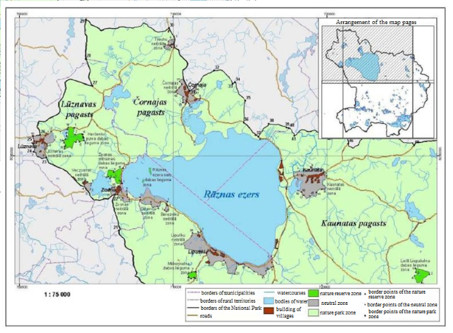
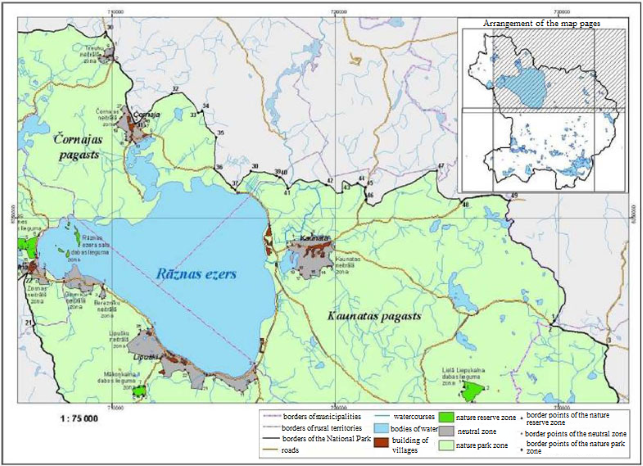
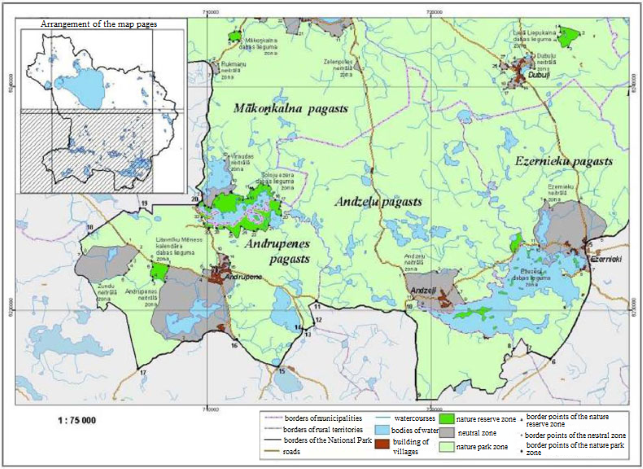
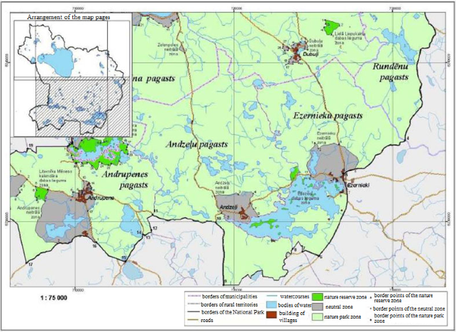
Section 2.
Borders of the National Park have been determined in
accordance with the scheme of the external borders and the
functional zone borders of the Rāzna National Park (Annex 1) and
the description of borders of the Rāzna National Park (Annex 2)
that have been annexed to this Law.
Section 3.
(1) The individual regulations regarding protection and use of
the Rāzna National Park shall lay down the procedures for the
protection and use of the National Park, permitted and prohibited
activities therein.
(2) The individual regulations regarding protection and use of
the Rāzna National Park shall be governed by the Cabinet.
Section 4.
The land of a nature reserve zone and a nature park zone that
is under jurisdiction of the State shall be registered in the
Land Register on behalf of the State by the Ministry of
Environmental Protection and Regional Development.
[16 December 2010]
Chapter II
Functional Zones
Section 5.
(1) In order to ensure protection of natural ecosystems,
preservation of the diversity of landscapes and genetic and
biological diversity of species, and also economic development of
the territory, the territory of the National Park shall be
divided into the following functional zones:
1) the nature reserve zone;
2) the nature park zone;
3) the neutral zone.
(2) Borders of the functional zones of the National Park have
been determined in Annex 1 annexed to this Law, and the
description of the borders of such functional zones has been
provided in Annex 2 annexed to this Law.
Section 6.
The nature reserve zone has been established in order to
protect the ecosystems lightly touched by human activities,
preserve occurrences of rare and disappearing species, and also
to preserve specially protected species and biotopes.
Section 7.
The nature park zone has been established in order to ensure
preservation of environment appropriate for recreation and
tourism, use of nature-friendly farming methods, and also to
preserve natural and cultural landscapes, and reduce the
anthropogenic impact on the nature reserve zone.
Section 8.
The neutral zone has been established in order to facilitate
balanced and sustainable development of populated areas located
in the National Park, preserve the landscape and architecture
specific to the municipality.
Chapter III
Administration of the National Park
Section 9.
(1) The National Park shall be administered by the Nature
Conservation Agency (hereinafter - the Agency) that is an
institution of direct administration subordinate to the Minister
for Environmental Protection and Regional Development.
(2) Administrative activity of the National Park shall be
governed by the by-laws approved by the Cabinet.
[30 April 2009; 16 December 2010]
Section 10.
[30 April 2009]
Section 11.
[30 April 2009]
Section 12.
(1) The Advisory Council of the National Park shall be
established in order to coordinate interests of environmental
protection and economic activity in the territory of the National
Park. The Council shall be composed of one representative from
the Ministry of Environmental Protection and Regional
Development, the State Forestry Service, valsts akciju
sabiedrība "Latvijas Valsts meži" [State stock company
Latvian State Forests], Southern and Eastern Latgale regional
agricultural administrations, Latgale planning council,
Daugavpils University, local governments which are located in the
territory of the National Park. The Council may be composed of
not more than four representatives from associations or
foundations the activities of which are related to the
environmental or nature protection or environmental
education.
(2) The Cabinet shall approve the by-laws of the Advisory
Council of the National Park.
(3) The Minister for Environmental Protection and Regional
Development shall approve the personnel of the Advisory Council
of the National Park.
[30 April 2009; 16 December 2010]
Section 13.
Decisions taken by the Director of the Administration of the
Rāzna National Park to establish, change, or terminate a legal
status of an official or to impose a disciplinary punishment on
this person, and also any other decisions which substantially
limit human rights of an official may be contested before the
Ministry of Environmental Protection and Regional
Development.
[14 June 2007; 30 April 2009; 16 December 2010]
Transitional Provisions
1. The Cabinet shall, by 1 December 2007, issue the
regulations referred to in Section 3, Paragraph two of this
Law.
[14 June 2007]
2. Until the day of coming into force of the Cabinet
regulations provided for in Section 3, Paragraph two of this Law,
but not longer than until 1 December 2007, Cabinet Regulation No.
264 of 8 April 2004, Individual Regulations Regarding Protection
and Use of the Natural Park Rāzna, shall be applied insofar as
they are not in conflict with this Law.
[14 June 2007]
3. The Cabinet shall approve the by-laws of the Administration
of the Rāzna National Park by 1 July 2007.
4. The Cabinet shall approve the by-laws of the Advisory
Council of the Rāzna National Park by 1 February 2007.
[25 January 2007]
5. Until establishment of the Administration of the National
Park, the functions laid down in laws and regulations shall be
performed by the Rēzekne Regional Environmental Board of the
State Environmental Service, except for the issue of the
certifications referred to in Section 39, Paragraph one of the
Law on Forests and the issue of the administrative acts referred
to in the laws and regulations governing hunting.
[25 January 2007]
6. [14 June 2007]
7. The contracts entered into until 1 January 2007 for the
right to extract timber and the right to use non-wood values in
State forest lands which, in accordance with this Law, are to be
registered in the Land Register in on behalf of the State by the
Ministry of Environmental Protection and Regional Development
shall be valid until fulfilment of obligations thereof, unless
they are in conflict with this Law.
[25 January 2007; 16 December 2010]
8. The reserve shall be administered by the Administration of
the Rāzna National Park until 1 June 2009.
[30 April 2009]
9. Amendments to Annexes 1 and 2 to this Law regarding
coordination of the scheme and description of the borders of the
Rāzna National Park with the Law on Administrative Territories
and Populated Areas shall come into force on 1 July 2009.
[30 April 2009]
10. Amendments to this Law which provide for the replacement
of the words "district of Rēzekne" (in the relevant case) with
the words "Rēzekne municipality" (in the relevant case),
"district of Krāslava" (in the relevant case) with the words
"Dagda municipality" (in the relevant case) in Annex 2, and also
the replacement of the words "Čornaja rural territory" with the
word "local government" in Sub-paragraph 17.20 shall come into
force on 1 July 2009.
[30 April 2009]
11. Until 1 July 2009, the term "regional motor road" (in the
relevant case) used in Annex 2 to this Law shall mean the term
"Category 1 motor road" (in the relevant case), while the term
"local motor road"(in the relevant case) shall mean the term
"Category 2 motor road" (in the relevant case).
[30 April 2009]
The Law shall come into force on 1 January 2007.
This Law has been adopted by the Saeima on 2 November
2006.
President V. Vīķe-Freiberga
Rīga, 15 November 2006
Rāzna National Park Law
Annex 1
Scheme of the External Borders and
the Functional Zone Borders of the Rāzna National Park
[30 April 2009. Amendments
regarding coordination of the scheme with the Law on
Administrative Territories and Populated Areas shall come into
force on 1 July 2009. See Transitional Provisions]
Rāzna National Park Law
Annex 2
Description of the Borders of the
Rāzna National Park
[25 January 2007; 30 April 2009.
Amendments regarding coordination of the description of borders
with the Law on Administrative Territories and Populated Areas
shall come into force on 1 July 2009. See Transitional
Provisions]
I. Description
of the External Border of the Rāzna National Park
1. Description of the border sections of the external
border
|
1
|
2
|
3 |
|
No.
|
The number of the border
sections according to the plan
|
The situation elements of the
plan according to which the border has been determined
|
|
1
|
2
|
3
|
|
1.1.
|
1-2
|
From the intersection of the
borders of Kaunata, Rundēni, and Pilda rural territories due
south-west along the border of Kaunata and Rundēni rural
territories to the Roceva-Rudzīši road |
|
1.2.
|
2-3
|
Due east along the southern side
of the Roceva-Rudzīši road to the Ludza-Ezernieki road |
|
1.3.
|
3-4
|
Due south along the western side
of the Ludza-Ezernieki road to the border of Rundēni and
Ezernieki rural territories |
|
1.4.
|
4-5
|
From the border of Rundēni and
Ezernieki rural territories and intersection of the
Ludza-Ezernieki road due south-west along the north-western
side of the Ludza-Ezernieki road to the Ezernieki-Dagda
road |
|
1.5.
|
5-6
|
Due south and south-west along
the north-western side of the Ezernieki-Dagda road to the
Novamisļi-Obiteļs road |
|
1.6.
|
6-7
|
Due west along the northern side
of the Novamisļi-Obiteļs road to the border of Ezernieki and
Dagda rural territories |
|
1.7.
|
7-8
|
Due north and north-west along
the border of Ezernieki and Dagda rural territories to the
intersection of borders of Andzeļi and Dagda rural
territories |
|
1.8.
|
8-9
|
From the intersection of the
borders of Ezernieki, Andzeļi, and Dagda rural territories
due south-west and west along the border of Andzeļi and Dagda
rural territories to the Artjomovka-Andzeļi road |
|
1.9.
|
9-10
|
Due north along the eastern side
of the Artjomovka-Andzeļi road to the Andzeļi-Andrupene
road |
|
1.10.
|
10-11
|
Due west along the northern side
of the Andzeļi-Andrupene road to the border of Andrupene
rural territory |
|
1.11.
|
11-12
|
From the border of Andzeļi and
Andrupene rural territories and the intersection of the
Andzeļi-Andrupene road due south-west and south along the
border of Andzeļi and Andrupene rural territories to the
stream of (the Lake) Kazimirovas ezers. |
|
1.12.
|
12-13
|
Due south-west along the stream
of (the Lake) Kazimirovas ezers to the Usači-Oloveca
road |
|
1.13.
|
13-14
|
Due west along the northern side
of the Usači-Oloveca road to the Oloveca-Andeņi road |
|
1.14.
|
14-15
|
Due south and south-west along
the western side of the Oloveca-Andeņi road to the
Andrupene-Dagda road |
|
1.15.
|
15-16
|
Due north-west along the
north-eastern side of the Andrupene-Dagda road to the
Mariampole-Jaunokra road |
|
1.16.
|
16-17
|
Due south-west along the
north-western side of the Mariampole-Jaunokra road to the
border of Andrupene and Kastuļina rural territories |
|
1.17.
|
17-18
|
Due north along the border of
Andrupene and Kastuļina rural territories to the intersection
of borders of Andrupene, Kastuļina, and Puša rural
territories |
|
1.18.
|
18-19
|
Due east from the intersection
of borders of Andrupene, Kastuļina, and Puša rural
territories to the intersection of borders of Andrupene,
Puša, and Mākoņkalns rural territories |
|
1.19.
|
19-20
|
From the intersection of borders
of Andrupene, Puša, and Mākoņkalns rural territories due east
to the Andrupene-Zosna road |
|
1.20.
|
20-21
|
Due north along the eastern side
of the Andrupene-Zosna road to the intersection of the border
of Mākoņkalns and Lūznava rural territories and the
Andrupene-Zosna road |
|
1.21.
|
21-22
|
From the intersection of the
border of Mākoņkalns and Lūznava rural territories and the
Andrupene-Zosna road due north along the eastern side of the
Andrupene-Zosna road to the Zosna-Lūznava road |
|
1.22.
|
22--23
|
Due west and north-west along
the north-eastern side of the Zosna-Lūznava road to the
gully |
|
1.23.
|
23--24
|
Due west and north-west along
the gully and the southern and south-eastern borders of the
land property (cadastre No. 78680040222; cadastre No.
78680020333; cadastre No. 78680020248; cadastre No.
78680020304; cadastre No. 78680020276; cadastre No.
78680020325; cadastre No. 7868002040) to (the River)
Vertušankas upīte |
|
1.24.
|
24-25
|
Due north along the right shore
of (the River) Vertušankas upīte and the eastern border of
the land property (cadastre No. 78680020094; cadastre No.
78680020006; cadastre No. 78680020172; cadastre No.
78680020010; cadastre No. 78680020123; cadastre No.
78680020261, and cadastre No. 8680020022) to the
Vērtukšņa-Lūznava road |
|
1.25.
|
25-26
|
Due east along the southern side
of the Vērtūkšņa-Lūznava road to the
Lūznava-Ļadi-Gudeļi-Ismeri road |
|
1.26.
|
26-27
|
Due north, north-east, and east
along the south-eastern side of the
Lūznava-Ļadi-Gudeļi-Ismeri road to the Ismeri-Rēzekne
road |
|
1.27.
|
27--28
|
Due north along the eastern side
of the Ismeri-Rēzekne road to the intersection of borders of
Lūznava and Čornaja rural territories |
|
1.28.
|
28-29
|
From the intersection of borders
of Lūznava and Čornaja rural territories due south along the
eastern side of the Ismeri-Rēzekne road and border of Čornaja
rural territory to the Gaiduļi-Putreiši-Mahoņina-Patrejevka
road |
|
1.29.
|
29-30
|
Due east along the southern side
of the Gaiduļi-Putreiši-Mahoņina-Patrejevka road to the P-55
Rēzekne-Janopole-Čornaja-Dagda road |
|
1.30.
|
30--31
|
Due south along the western side
of the P-55 Rēzekne- Janopole-Čornaja-Dagda road to the
Čornaja-Balinova road |
|
1.31.
|
31-32
|
Due north-east along the
north-eastern side of the Čornaja-Balinova road to the
Balinova-Pirmie Balteņi road |
|
1.32.
|
32-33
|
Due south-east along the
south-western part of the Balinova-Pirmie Baļteņi road to the
Baltais Dukstigals-Soboļeva-Pirmie Baļteņi road |
|
1.33.
|
33-34
|
Due north-east along the
north-eastern side of the Baltais Dukstigals-Soboļeva-Pirmie
Baļteņi road to the Baļteņi-Račiki road |
|
1.34.
|
34-35
|
Due south and south-east along
the south-western side of the Baļteņi-Račiki road to the
Račiki-Uškāni road |
|
1.35.
|
35--36
|
Due south along the western side
of the Račiki-Uškāni road to the P-55
Rēzekne-Janopole-Čornaja-Dagda road |
|
1.36.
|
36--37
|
Due south-east along the
south-western side of the P-55 Rēzekne-
Janopole-Čornaja-Dagda road to the Foļvarkova-Baļteņi
road |
|
1.37.
|
37--38
|
Due north-east along the
south-eastern side of the Foļvarkova-Baļteņi road to the
Foļvarkova-Kazeiki road |
|
1.38.
|
38-39
|
Due east along the southern side
of the Foļvarkova-Kazeiki road to the Kazeiki-Graši road |
|
1.39.
|
39-40
|
Due east along the southern side
of the Kazeiki-Graši road to the border of Čornaja and
Kaunata rural territories |
|
1.40.
|
40-41
|
From the intersection of the
Kazeiki-Graši road and borders of Čornaja and Kaunata rural
territories due south-east along the south-western side of
the Kazeiki-Graši road to the Graši-Mozgi-Batņi road |
|
1.41.
|
41-42
|
Due east along the southern side
of the Graši-Mozgi-Batņi road to the gully |
|
1.42.
|
42-43
|
Due south-east along the gully
to the south-eastern corner of the land property (cadastre
No. 78620020014) |
|
1.43.
|
43-44
|
Due north and east along the
gully and northern border of the land property (cadastre No.
78620020014; cadastre No. 78620020243, and cadastre No.
78620020234) to the northern corner of the land property
(cadastre No. 78620020234) |
|
1.44.
|
44-45
|
Due east along the north-eastern
border of the land property (cadastre No. 78620020234) to the
Ostrovski-Vecsloboda road |
|
1.45.
|
45-46
|
Due south along the western side
of the Ostrovski-Vecsloboda road to the Vecsloboda-Mežavaja
road |
|
1.46.
|
46-47
|
Due south-east along the
north-eastern border of the land property (cadastre No.
78620020023) to the south-eastern side of the
Vecsloboda-Mežavaja road and along the south-eastern side of
the Vecsloboda-Mežavaja road and the north-western border of
the land property (cadastre No. 78620020210; cadastre No.
78620020113; cadastre No. 78620020128; cadastre No.
78620020129; cadastre No. 78620020107; cadastre No.
78620030265; cadastre No. 78620030020; cadastre No
78620030080; cadastre No. 78620030091; cadastre No.
78620030266; cadastre No7 8620030007; cadastre No.
78620030107) to the north-eastern corner of the land property
(cadastre No. 78620030107) |
|
1.47.
|
47-48
|
Due south and south-east along
the south-western border of the land property (cadastre No.
78620030107; cadastre No. 78620030037; cadastre No.
78620030095; cadastre No. 78620030092; cadastre No.
78620030103; cadastre No. 78620030105) to the Kaunata-Rogaiža
road |
|
1.48.
|
48-49
|
Due east along the southern side
of the Kaunata-Rogaiža road to the border of Kaunata and
Rundēni rural territories |
|
1.49.
|
49-1
|
Due south along the border of
Kaunata and Rundēni rural territories to the starting point
(intersection of the borders of Kaunata, Rundēni, and Pilda
rural territories) |
2. Coordinates of the border points of the external border
| |
1
|
2
|
3
|
|
No.
|
Border point
|
X coordinate
|
Y coordinate
|
| |
1
|
2
|
3
|
|
2.1.
|
1
|
729798
|
6245375
|
|
2.2.
|
2
|
729630
|
6245217
|
|
2.3.
|
3
|
732168
|
6244295
|
|
2.4.
|
4
|
730771
|
6235105
|
|
2.5.
|
5
|
726891
|
6232987
|
|
2.6.
|
6
|
725334
|
6227816
|
|
2.7.
|
7
|
724312
|
6228083
|
|
2.8.
|
8
|
723699
|
6228265
|
|
2.9.
|
9
|
719348
|
6225991
|
|
2.10.
|
10
|
718836
|
6229943
|
|
2.11.
|
11
|
714865
|
6230426
|
|
2.12.
|
12
|
714779
|
6229424
|
|
2.13.
|
13
|
714401
|
6229117
|
|
2.14.
|
14
|
714248
|
6229176
|
|
2.15.
|
15
|
713162
|
6227475
|
|
2.16.
|
16
|
711313
|
6228687
|
|
2.17.
|
17
|
706911
|
6227366
|
|
2.18.
|
18
|
704703
|
6233415
|
|
2.19.
|
19
|
706990
|
6234559
|
|
2.20.
|
20
|
709533
|
6234724
|
|
2.21.
|
21
|
706463
|
6245149
|
|
2.22.
|
22
|
706195
|
6247490
|
|
2.23.
|
23
|
701746
|
6249880
|
|
2.24.
|
24
|
700897
|
6250255
|
|
2.25.
|
25
|
700848
|
6251273
|
|
2.26.
|
26
|
701853
|
6251393
|
|
2.27.
|
27
|
704730
|
6254548
|
|
2.28.
|
28
|
704302
|
6256288
|
|
2.29.
|
29
|
704306
|
6258826
|
|
2.30.
|
30
|
709706
|
6258275
|
|
2.31.
|
31
|
711049
|
6254198
|
|
2.32.
|
32
|
712657
|
6255537
|
|
2.33.
|
33
|
713853
|
6254675
|
|
2.34.
|
34
|
714011
|
6254766
|
|
2.35.
|
35
|
714676
|
6253576
|
|
2.36.
|
36
|
714563
|
6252167
|
|
2.37.
|
37
|
715520
|
6251224
|
|
2.38.
|
38
|
716204
|
6252080
|
|
2.39.
|
39
|
717350
|
6251843
|
|
2.40.
|
40
|
717506
|
6251792
|
|
2.41.
|
41
|
717856
|
6251289
|
|
2.42.
|
42
|
719576
|
6251441
|
|
2.43.
|
43
|
720316
|
6251153
|
|
2.44.
|
44
|
720973
|
6251528
|
|
2.45.
|
45
|
721347
|
6251342
|
|
2.46.
|
46
|
721360
|
6250785
|
|
2.47.
|
47
|
724533
|
6252100
|
|
2.48.
|
48
|
725653
|
6250679
|
|
2.49.
|
49
|
727818
|
6250760
|
II. Description
of the Border of the Nature Reserve Zone
1. Description of the border sections of the nature reserve
zone of (the Swamp) Harčenku purvs
|
No.
|
The number of border sections
according to the plan
|
The situation elements of the
plan according to which the border has been determined
|
|
Rēzekne
municipality. Lūznava rural territory
|
|
1.1.
|
1-2
|
From the intersection of the
Lūznava-Ismeri local motor road and the land property
(cadastre No. 78680050121) due south, south-east, and east
along the border of the land property (cadastre No.
78680050121) to the southern border of the land property
(cadastre No. 78680050229) |
|
1.2.
|
2-3
|
Due east along the southern
border of the land property (cadastre No. 78680050229) to the
south-eastern corner of the land property (cadastre No.
78680050229) |
|
1.3.
|
3-4
|
Due east from the south-eastern
corner of the land property (cadastre No. 78680050229) to the
northern corner of the land property (cadastre No.
78680050069) |
|
1.4.
|
4-5
|
Due south-west and south-east
along the western border of the land property (cadastre No.
78680050069) to the southern corner of the land property
(cadastre No. 78680050069) |
|
1.5.
|
5-6
|
Due south-east from the southern
corner of the land property (cadastre No. 78680050069) to the
intersection of the northern shore of (the Lake) Rubčinsku
ezers and the land property (cadastre No. 78680050186) |
|
1.6.
|
6-7
|
Due west and south from the
intersection of the northern shore of (the Lake) Rubčinsku
ezers and the land property (cadastre No. 78680050186) along
the western shore of (the Lake) Rubčinsku ezers to the
intersection of the western shore of (the Lake) Rubčinsku
ezers and the land property (cadastre No. 78680050217) |
|
1.7.
|
7-8
|
Due west from the intersection
of the western shore of (the Lake) Rubčinsku ezers and the
land property (cadastre No. 78680050217) along the southern
border of the land property (cadastre No. 78680050217) to the
south-eastern corner of the land property (cadastre No.
78680020437) |
|
1.8.
|
8-9
|
Due north-west and south-west
from the south-eastern corner of the land property (cadastre
No. 78680020437) along the north-eastern and north-western
borders of the land property (cadastre No. 78680020437) to
the eastern border of the land property (cadastre No.
78680020465) |
|
1.9.
|
9-10
|
Due west, south-west, and west
along the eastern and southern borders of the land property
(cadastre No. 78680020465) to the south-western corner of the
land property (cadastre No. 78680020465) |
|
1.10.
|
10-11
|
Due north from the south-western
corner of the land property (cadastre No. 78680020465) along
the western border of the land property (cadastre No.
78680020465) to the western corner of the land property
(cadastre No. 78680020465) |
|
1.11.
|
11-12
|
Due north-east from the western
corner of the land property (cadastre No. 78680020465) to the
south-eastern corner of the land property (cadastre No.
78680020403) |
|
1.12.
|
12-13
|
Due north-west from the
south-eastern corner of the land property (cadastre No.
78680020403) along the north-eastern border of the land
property (cadastre No. 78680020403) to the southern corner of
the land property (cadastre No. 78680020200) |
|
1.13.
|
13-14
|
Due north-east and north-west
from the southern corner of the land property (cadastre No.
78680020200) along the south-eastern and north-eastern
borders of the land property (cadastre No. 78680020200) to
the amelioration ditch |
|
1.14.
|
14-15
|
Due north-east along the
amelioration ditch to the western shore of (the Lake)
Harčenku ezers |
|
1.15.
|
15-16
|
Due south-east and north along
the western, south-western, and eastern shores of (the Lake)
Harčenku ezers to the border of the land property (cadastre
No. 78680020502) |
|
1.16.
|
16-17
|
Due south-east, north, and west
along the border of the land property (cadastre No.
78680020502) to the eastern shore of (the Lake) Harčenku
ezers |
|
1.17.
|
17-18
|
Due north-east and north-west
along the western shore of (the Lake) Harčenku ezers to the
mouth of the stream on the northern shore of the Lake |
|
1.18.
|
18-19
|
Due north along the stream to
the southern side of the Lūznava-Ismeri local motor road |
|
1.19.
|
19-1
|
Due east along the southern side
of the Lūznava-Ismeri local motor road to the starting
point |
2. Coordinates of border points of the nature reserve zone of
(the Swamp) Harčenku purvs
|
No.
|
Border point
|
X coordinate
|
Y coordinate
|
|
2.1.
|
1
|
703558
|
6251844
|
|
2.2.
|
2
|
703628
|
6251396
|
|
2.3.
|
3
|
704054
|
6251421
|
|
2.4.
|
4
|
704126
|
6251416
|
|
2.5.
|
5
|
704139
|
6251274
|
|
2.6.
|
6
|
704180
|
6251195
|
|
2.7.
|
7
|
704193
|
6251019
|
|
2.8.
|
8
|
703888
|
6250930
|
|
2.9.
|
9
|
703661
|
6250896
|
|
2.10.
|
10
|
702933
|
6250480
|
|
2.11.
|
11
|
702943
|
6250623
|
|
2.12.
|
12
|
702991
|
6250683
|
|
2.13.
|
13
|
702890
|
6250863
|
|
2.14.
|
14
|
702851
|
6251013
|
|
2.15.
|
15
|
702998
|
6251109
|
|
2.16.
|
16
|
703049
|
6251315
|
|
2.17.
|
17
|
703039
|
6251519
|
|
2.18.
|
18
|
703102
|
6251725
|
|
2.19.
|
19
|
703162
|
6251852
|
3. Description of the border sections of the nature reserve
zone of (the Wetland) Zosnas mitraine
|
No.
|
The number of border sections
according to the plan
|
The situation elements of the
plan according to which the border has been determined
|
|
Rēzekne
municipality. Lūznava rural territory
|
|
3.1.
|
1-2
|
From the intersection of the
western side of the Zosna-Višķeri road and the southern
border of the land property (cadastre No. 78680050127) due
west, south, and north-west along the southern border of the
land property (cadastre No. 78680050127) to the canalised
culvert of (the Lake) Zosnas ezers and (the Lake) Rāznas
ezers |
|
3.2.
|
2-3
|
Due west along the canalised
culvert of (the Lake) Zosnas ezers and (the Lake) Rāznas
ezers to the eastern shore of (the Lake) Zosnas ezers |
|
3.3.
|
3-4
|
Due north-east along the eastern
shore of (the Lake) Zosnas ezers to the southern border of
the land property (cadastre No. 78680050064) |
|
3.4.
|
4-5
|
Due north, east, and south along
the border of the land property (cadastre No. 78680050064) to
the cross-ride |
|
3.5.
|
5-6
|
Due north-east along the
cross-ride to the Zosna-Višķeri road and the south-western
corner of the land property (cadastre No. 78680050097) |
|
3.6.
|
6-1
|
Due south along the western side
of the Zosna-Višķeri road to the starting point |
4. Coordinates of the border points of the nature reserve zone
of (the Wetland) Zosnas mitraine
|
No.
|
Border point
|
X coordinate
|
Y coordinate
|
|
4.1.
|
1
|
706590
|
6248374
|
|
4.2.
|
2
|
706130
|
6248616
|
|
4.3.
|
3
|
705885
|
6248549
|
|
4.4.
|
4
|
705763
|
6248676
|
|
4.5.
|
5
|
706114
|
6248945
|
|
4.6.
|
6
|
706856
|
6249413
|
5. Description of the border of the nature reserve zone of
(the Lake) Rāznas ezers islands
|
No.
|
The number of border sections
according to the plan
|
The situation elements of the
plan according to which the border has been determined
|
|
Rēzekne
municipality. Mākoņkalns rural territory
|
|
5.1.
|
|
Six islands of (the Lake) Rāznas
ezers in the western part of (the Lake) Rāznas ezers. Border
of the nature reserve coincides with the shoreline of
islands |
6. Description of the border of the Mākoņkalns nature reserve
zone
|
No.
|
The number of border sections
according to the plan
|
The situation elements of the
plan according to which the border has been determined
|
|
Rēzekne
municipality. Mākoņkalns rural territory
|
|
6.1.
|
1-2
|
From the intersection of the
northern border of the land property (cadastre No.
78720070003) and the Andrupene-Ļipuški local motor road along
the western side of the Andrupene-Ļipuški local motor road to
the southern corner of the land property (cadastre No.
78720070087) |
|
6.2.
|
2-3
|
Due north-west along the
south-western border of the land property (cadastre No.
78720070087) to the eastern corner of the land property
(cadastre No. 78720070074) |
|
6.3.
|
3-4
|
Due south-west along the
south-eastern border of the land property (cadastre No.
78720070074) to the Rukmaņi-Voveri dirt road |
|
6.4.
|
4-5
|
Due west along the
Rukmaņi-Voveri dirt road to the western border of the land
property (cadastre No. 78720070074) |
|
6.5.
|
5-6
|
Due north and north-east along
the western border of the land property (cadastre No.
78720070074) to the southern corner of the land property
(cadastre No. 78720070119) |
|
6.6.
|
6-7
|
Due north, north-west, east, and
north-east along the western and northern borders of the land
property (cadastre No. 78720070119) to the western border of
the land property (cadastre No. 78720070087) |
|
6.7.
|
7-8
|
Due north and east along the
western and northern borders of the land property (cadastre
No. 78720070087) to the north-western corner of the land
property (cadastre No. 78720070003) |
|
6.8.
|
8-1
|
Due east along the northern
border of the land property (cadastre No. 78720070003) to the
starting point |
7. Coordinates of the border points of the Mākoņkalns nature
reserve zone
|
No.
|
Border point
|
X coordinate
|
Y coordinate
|
|
7.1.
|
1
|
711455
|
6242460
|
|
7.2.
|
2
|
711412
|
6242036
|
|
7.3.
|
3
|
711352
|
6242095
|
|
7.4.
|
4
|
711168
|
6242023
|
|
7.5.
|
5
|
710959
|
6242093
|
|
7.6.
|
6
|
710975
|
6242134
|
|
7.7.
|
7
|
711194
|
6242445
|
|
7.8.
|
8
|
711415
|
6242459
|
8. Description of the border of the Lielais Liepukalns nature
reserve zone
|
No.
|
The number of border sections
according to the plan
|
The situation elements of the
plan according to which the border has been determined
|
|
Rēzekne
municipality. Kaunata rural territory
|
|
8.1.
|
1-2
|
From the western corner of the
land property (cadastre No. 78620130016) along the northern
border of the land property (cadastre No. 78620130016) to the
northern border of the land property (cadastre No.
78620130018) |
|
8.2.
|
2-3
|
Due east along the northern
border of the land property (cadastre No. 78620130018) to the
eastern corner of the land property (cadastre No.
78620130018) |
|
8.3.
|
3-4
|
Due south-west along the
south-eastern border of the land property (cadastre No.
78620130018) to the forest road and the northern border of
the land property (cadastre No. 78620130032) |
|
8.4.
|
4-5
|
Due west along the forest road
and the northern border of the land property (cadastre No.
78620130032) to the western border of the land property
(cadastre No. 78620130018) |
|
8.5.
|
5-1
|
Due north along the western
border of the land property (cadastre No. 78620130018) to the
starting point |
9. Coordinates of the border points of the Lielais Liepukalns
nature reserve zone
|
No.
|
Border point
|
X coordinate
|
Y coordinate
|
|
9.1.
|
1
|
725715
|
6242710
|
|
9.2.
|
2
|
726196
|
6242497
|
|
9.3.
|
3
|
726755
|
6242357
|
|
9.4.
|
4
|
726322
|
6241796
|
|
9.5.
|
5
|
725973
|
6241715
|
10. Description of the border of the nature reserve zone of
(the Lake) Salāju ezers
|
No.
|
The number of border sections
according to the plan
|
The situation elements of the
plan according to which the border has been determined
|
|
Rēzekne
municipality. Mākoņkalns rural territory
|
|
10.1.
|
1-2
|
From the intersection of the
border of Andrupene rural territory, Dagda municipality and
Mākoņkalns rural territory, Rēzekne municipality and the
Andrupene-Ļipuški local motor road due north-east along the
south-eastern side of the Andrupene-Ļipuški local motor road
to the north-eastern border of the land property (cadastre
No. 78720100162) |
|
10.2.
|
2-3
|
Due south-east along the
north-eastern border of the land property (cadastre No.
78720100162) to the northern border of the land property
(cadastre No. 78720100188) |
|
10.3.
|
3-4
|
Due north-east and south-east
along the northern border of the land property (cadastre No.
78720100188) to the north-western corner of the land property
(cadastre No. 78720100064) |
|
10.4.
|
4-5
|
Due north-east and south-east
along the northern border of the land property (cadastre No.
78720100064) to the intersection of the border of the land
property (cadastre No. 78720100089) and the shoreline of (the
Lake) Salāju ezers |
|
10.5.
|
5-6
|
Due north-east from the
intersection of the border of the land property (cadastre No.
78720100089) and the shoreline of (the Lake) Salāju ezers
along the north-western border of the land property (cadastre
No. 78720100089) to the western corner of the land property
(cadastre No. 78720100192) |
|
10.6.
|
6-7
|
Due north-east, east,
south-east, and north-east along the northern border of the
land property (cadastre No. 78720100192) to the south-western
shore of (the Lake) Adaļeņa ezers |
|
10.7.
|
7-8
|
Due south-east along the
south-western shore of (the Lake) Adaļeņa ezers to the
south-eastern border of the land property (cadastre No.
78720100195) |
|
10.8.
|
8-9
|
Due south-east and south along
the south-eastern border of the land property (cadastre No.
78720100195) to the north-western border of the land property
(cadastre No. 78720100163) |
|
10.9.
|
9-10
|
Due north-east along the
north-western border of the land property (cadastre No.
78720100163) to the southern corner of the land property
(cadastre No. 78720109007) |
|
10.10.
|
10-11
|
Due north-west and north-east
from the southern corner of the land property (cadastre No.
78720109007) along the western border of the land property
(cadastre No. 78720109007) to the southern border of the land
property (cadastre No. 78720100040) |
|
10.11.
|
11-12
|
Due east along the southern
border of the land property (cadastre No. 78720100040) to the
eastern border of the land property (cadastre No.
78720100013) |
|
10.12.
|
12-13
|
Due south-east along the eastern
border of the land property (cadastre No. 78720100013) to the
north-western border of the land property (cadastre No.
78720100132) |
|
10.13.
|
13-14
|
Due north-east and south-east
along the north-western and north-eastern borders of the land
property (cadastre No. 78720100132) to the northern border of
the land property (cadastre No. 78720100152) |
|
10.14.
|
14-15
|
Due east and south-east along
the northern and north-eastern borders of the land property
(cadastre No. 78720100152) to the edge of the forest |
|
10.15.
|
15-16
|
Due south-east along the edge of
the forest to (the River) Mostovuhas upīte (border of
Mākoņkalns and Andrupene rural territories) |
|
10.16.
|
16-17
|
Due east and south-east along
(the River) Mostovuhas upīte (border of Mākoņkalns and
Andrupene rural territories) to the north-eastern corner of
the land property (cadastre No. 60420020100) |
|
10.17.
|
17-18
|
Due south along the eastern
border of the land property (cadastre No. 60420020100) to the
north-eastern corner of the land property (cadastre No.
60420020068) |
|
10.18.
|
18-19
|
Due south along the eastern
border of the land property (cadastre No. 60420020068) to the
northern border of the land property (cadastre No.
60420020019) |
|
10.19.
|
19-20
|
Due east, south-east, and south
along the northern and eastern borders of the land property
(cadastre No. 60420020019) to the shore of (the Lake) Žīguru
(Žuguru) ezers |
|
10.20.
|
20-21
|
Due west, north-west, and south
along the northern and western shores of (the Lake) Žīguru
(Žuguru) ezers to the eastern corner of the land property
(cadastre No. 60420020039) |
|
10.21.
|
21-22
|
Due south-west, west, and
north-west along the eastern and southern borders of the land
property (cadastre No. 60420020039) to the eastern corner of
the land property (cadastre No. 60420020107) |
|
10.22.
|
22-23
|
Due south-west and north-west
along the eastern and southern borders of the land property
(cadastre No. 60420020107) to the south-eastern corner of the
land property (cadastre No. 60420020049) |
|
10.23.
|
23-24
|
Due west and and north-west
along the southern border of the land property (cadastre No.
60420020049) to the south-eastern corner of the land property
(cadastre No. 60420020051) |
|
10.24.
|
24-25
|
Due north-west along the
south-western border of the land property (cadastre No.
60420020051) to the eastern border of the land property
(cadastre No. 60420020006) |
|
10.25.
|
25-26
|
Due south, west, west, and
north-west along the eastern, southern, and south-western
borders of the land property (cadastre No. 60420020006) to
the eastern corner of the land property (cadastre No.
60420040073) |
|
10.26.
|
26--27
|
Due north-west along the
south-western border of the land property (cadastre No.
60420040073) to the eastern border of the land property
(cadastre No. 60420040005) |
|
10.27.
|
27-28
|
Due south, west, west, and north
along the eastern, southern, and western borders of the land
property (cadastre No. 60420040005) to the south-eastern
corner of the land property (cadastre No. 60420040008) |
|
10.28.
|
28-29
|
Due west along the southern
border of the land property (cadastre No. 60420040008) to the
south-eastern corner of the land property (cadastre No.
60420040150) |
|
10.29.
|
29-30
|
Due south-west along the
south-eastern border of the land property (cadastre No.
60420040150) to the eastern corner of the land property
(cadastre No. 60420040149) |
|
10.30.
|
30-31
|
Due south along the eastern
border of the land property (cadastre No. 60420040149) to the
north-eastern side of the Andrupene-Ļipuški local motor
road |
|
10.31.
|
31-32
|
Due north-west along the
north-eastern side of the Andrupene-Ļipuški local motor road
to the western corner of the land property (cadastre No.
60420040036) |
|
10.32.
|
32-33
|
Due east, north-east, north, and
west along the western border of the land property (cadastre
No. 60420040036) to the north-eastern side of the
Andrupene-Ļipuški local motor road |
|
10.33.
|
33-1
|
Due north-west and north along
the north-eastern side of the Andrupene-Ļipuški local motor
road to the starting point |
11. Coordinates of border points of the nature reserve zone of
(the Lake) Salāju ezers
|
No.
|
Border point
|
X coordinate
|
Y coordinate
|
|
11.1.
|
1
|
709533
|
6234724
|
|
11.2.
|
2
|
709751
|
6234900
|
|
11.3.
|
3
|
709889
|
6234700
|
|
11.4.
|
4
|
710025
|
6234620
|
|
11.5.
|
5
|
710151
|
6234569
|
|
11.6.
|
6
|
710394
|
6235118
|
|
11.7.
|
7
|
711013
|
6235298
|
|
11.8.
|
8
|
711084
|
6235259
|
|
11.9.
|
9
|
711575
|
6234946
|
|
11.10.
|
10
|
711819
|
6235017
|
|
11.11.
|
11
|
711914
|
6235479
|
|
11.12.
|
12
|
712014
|
6235480
|
|
11.13.
|
13
|
712060
|
6235405
|
|
11.14.
|
14
|
712504
|
6235618
|
|
11.15.
|
15
|
712735
|
6235588
|
|
11.16.
|
16
|
713023
|
6234944
|
|
11.17.
|
17
|
713300
|
6234855
|
|
11.18.
|
18
|
713242
|
6234684
|
|
11.19.
|
19
|
713190
|
6234531
|
|
11.20.
|
20
|
713295
|
6234241
|
|
11.21.
|
21
|
712754
|
6233806
|
|
11.22.
|
22
|
712246
|
6233639
|
|
11.23.
|
23
|
712070
|
6233544
|
|
11.24.
|
24
|
711652
|
6233647
|
|
11.25.
|
25
|
711483
|
6233762
|
|
11.26.
|
26
|
711025
|
6233507
|
|
11.27.
|
27
|
710737
|
6233721
|
|
11.28.
|
28
|
710409
|
6233674
|
|
11.29.
|
29
|
710078
|
6233695
|
|
11.30.
|
30
|
710038
|
6233668
|
|
11.31.
|
31
|
710028
|
6233648
|
|
11.32.
|
32
|
709837
|
6233892
|
|
11.33.
|
33
|
709748
|
6234166
|
12. Description of the border of the Litaunīku Mēness
kalendārs nature reserve
|
No.
|
The number of border sections
according to the plan
|
The situation elements of the
plan according to which the border has been determined
|
|
Dagda
municipality. Andrupene rural territory
|
|
12.1.
|
1-2
|
From the intersection of the
P-57 Dagda-Andrupene-Malta regional motor road and the
Biža-Bronkas-Litaunīki dirt road along the eastern side of
the Biža-Bronkas-Litaunīki dirt road due south to (the River)
Baldas upīte |
|
12.2.
|
2-3
|
Due west along (the River)
Baldas upīte to the western border of the land property
(cadastre No. 60420010135) |
|
12.3.
|
3-4
|
Due north along the western
border of the land property (cadastre No. 60420010135) to the
southern border of the land property (cadastre No.
60420010130) |
|
12.4.
|
4--5
|
Due west and north along the
southern and western borders of the land property (cadastre
No. 60420010130) to the south-western corner of the land
property (cadastre No. 60420010015) |
|
12.5.
|
5-6
|
Due north-west and north along
the south-western and western borders of the land property
(cadastre No. 60420010015) to the P-57 Dagda-Andrupene-Malta
regional motor road |
|
12.6.
|
6-1
|
Due south-east along the
south-western side of the P-57 Dagda-Andrupene-Malta regional
motor road to the starting point |
13. Coordinates of border points of the Litaunīku Mēness
kalendārs nature reserve zone
|
No.
|
Border point
|
X coordinate
|
Y coordinate
|
|
13.1.
|
1
|
708249
|
6232006
|
|
13.2.
|
2
|
708093
|
6231291
|
|
13.3.
|
3
|
707551
|
6231342
|
|
13.4.
|
4
|
707562
|
6231506
|
|
13.5.
|
5
|
707557
|
6231961
|
|
13.6.
|
6
|
707486
|
6232211
|
14. Description of the border of the Ežezers nature reserve
zone
|
No.
|
The number of border sections
according to the plan
|
The situation elements of the
plan according to which the border has been determined
|
|
Dagda
municipality.
14.1.
Ezernieki rural territory
|
|
14.1.1.
|
|
The nature reserve includes all
oak groves of (the Island) Ežezera sala and (the Peninsula)
Pahatnieku pussala (State forest compartment 311) |
|
14.2.
Andzeļi rural territory
|
|
14.2.1.
|
|
The nature reserve includes
Pilori oak grove (State forest compartment 311) |
III. Description
of the Border of the Neutral Zone
15. Description of the border of the Treuhi neutral zone
|
No.
|
The number of border sections
according to the plan
|
The situation elements of the
plan according to which the border has been determined
|
|
Rēzekne
municipality. Čornaja rural territory
|
|
15.1.
|
1-2
|
From the intersection of the
P-55 Rēzekne-Dagda regional motor road and gully due south
along the eastern side of the P-55 Rēzekne-Dagda regional
motor road to the Treuhi-Ismeri local motor road |
|
15.2.
|
2-3
|
Due south-west along the
south-eastern side of the Treuhi-Ismeri local motor road to
the southern border of the land property (cadastre No.
78460040167) |
|
15.3.
|
3-4
|
Due west along the southern
border of the land property (cadastre No. 78460040167) to the
eastern border of the land property (cadastre No.
78460040165) |
|
15.4.
|
4-5
|
Due north-west along the eastern
border of the land property (cadastre No. 78460040165) to the
southern border of the land property (cadastre No.
78460040172) |
|
15.5.
|
5-6
|
Due south-west, south, west,
north, and south-east along the southern border of the land
property (cadastre No. 78460040172) to the western border of
the land property (cadastre No. 78460040176) |
|
15.6.
|
6-7
|
Due north along the western
border of the land property (cadastre No. 78460040176) to the
Treuhi-Bratova local government road |
|
15.7.
|
7-8
|
Due east along the northern side
of the Treuhi-Bratova local government road to the western
border of the land property (cadastre No. 78460040170) |
|
15.8.
|
8-9
|
Due north along the western
border of the land property (cadastre No. 78460040170) to the
western corner of the land property (cadastre No.
78460040019) |
|
15.9.
|
9-10
|
Due north-east and east along
the western and northern borders of the land property
(cadastre No. 78460040019) to the gully |
|
15.10.
|
10-1
|
Due north and east along the
gully to the starting point |
16. Coordinates of the border points of the Treuhi neutral
zone
|
No.
|
Border point
|
X coordinate
|
Y coordinate
|
|
16.1.
|
1
|
710067
|
6257652
|
|
16.2.
|
2
|
710074
|
6257097
|
|
16.3.
|
3
|
710029
|
6257006
|
|
16.4.
|
4
|
709862
|
6257026
|
|
16.5.
|
5
|
709874
|
6257058
|
|
16.6.
|
6
|
709450
|
6257103
|
|
16.7.
|
7
|
709466
|
6257269
|
|
16.8.
|
8
|
709638
|
6257228
|
|
16.9.
|
9
|
709659
|
6257433
|
|
16.10.
|
10
|
709903
|
6257534
|
17. Description of the border of the Čornaja neutral zone
|
No.
|
The number of border sections
according to the plan
|
The situation elements of the
plan according to which the border has been determined
|
|
Rēzekne
municipality. Čornaja rural territory
|
|
17.1.
|
1-2
|
From the intersection of the
P-55 Rēzekne-Dagda regional motor road and the
Čornaja-Balinova road due north-east along the north-western
side of the Čornaja-Balinova road to the northern corner of
the land property (cadastre No. 78460070056) |
|
17.2.
|
2-3
|
Due south-east and east along
the northern and eastern borders of the land property
(cadastre No. 78460070056) to the northern border of the land
property (cadastre No. 78460070057) |
|
17.3.
|
3-4
|
Due south-east along the
north-eastern border of the land property (cadastre No.
78460070057) to the western border of the land property
(cadastre No. 78460070142) |
|
17.4.
|
4-5
|
Due south-west along the western
border of the land property (cadastre No. 78460070142) to the
eastern border of the land property (cadastre No.
78460070058) |
|
17.5.
|
5-6
|
Due south along the eastern
border of the land property (cadastre No. 78460070058) to the
P-55 Rēzekne-Dagda regional motor road |
|
17.6.
|
6-7
|
Due south-east along the eastern
side of the P-55 Rēzekne-Dagda regional motor road to the
gully to (the Lake) Rāznas ezers |
|
17.7.
|
7-8
|
Due south along the gully to the
shore of (the Lake) Rāznas ezers |
|
17.8.
|
8-9
|
Due north-west along the shore
of (the Lake) Rāznas ezers to the southern corner of the land
property (cadastre No. 78460070076) |
|
17.9.
|
9-10
|
Due north-west along the
south-western border of the land property (cadastre No.
78460070076) to the south-western border of the land property
(cadastre No. 78460070075) |
|
17.10.
|
10-11
|
Due north-west along the
south-western border of the land property (cadastre No.
78460070075) to the southern border of the land property
(cadastre No. 78460070230) |
|
17.11.
|
11-12
|
Due west along the southern
border of the land property (cadastre No. 78460070230) to the
Čornaja-Melndukstigals local government road |
|
17.12.
|
12-13
|
Due south-west along the
south-eastern side of the Čornaja-Melndukstigals local
government road to the eastern corner of the land property
(cadastre No. 78460070177) |
|
17.13.
|
13-14
|
Due north-west along the
northern border of the land property (cadastre No.
78460070177) to the eastern border of the land property
(cadastre No. 78460070064) |
|
17.14.
|
14-15
|
Due south, west, and north along
the border of the land property (cadastre No. 78460070064) to
the eastern border of the land property (cadastre No.
78460070061) |
|
17.15.
|
15-16
|
Due north along the eastern
border of the land property (cadastre No. 78460070061) to the
south-western corner of the land property (cadastre No.
78460070208) |
|
17.16.
|
16-17
|
Due north, west, and north-east
along the western border of the land property (cadastre No.
78460070208) to the southern corner of the land property
(cadastre No. 78460070148) |
|
17.17.
|
17-18
|
Due north-west along the border
of the land property (cadastre No. 78460070148) and the land
property (cadastre No. 78460070288) to the southern corner of
the land property (cadastre No. 78460070005) |
|
17.18.
|
18-19
|
Due north-west along the
south-western border of the land property (cadastre No.
78460070005) to the southern corner of the land property
(cadastre No. 78460070086) |
|
17.19.
|
19-20
|
Due north-east along the
north-eastern border of the land property (cadastre No.
78460070086) to the southern corner of the land property
(cadastre No. 78460070085) |
|
17.20.
|
20-21
|
Due north-east along the border
of the local government land to the border of the land
property (cadastre No. 78460070085) |
|
17.21.
|
21-22
|
Due north-east along the
south-eastern border of the land property (cadastre No.
78460070085) to the south-eastern border of the land property
(cadastre No. 78460070087) |
|
17.22.
|
22-23
|
Due north-east along the
south-eastern border of the land property (cadastre No.
78460070087) to the Čornaja-Žogoti local government road |
|
17.23.
|
23-24
|
Due north-west along the
south-western side of the Čornaja-Žogoti local government
road to the western corner of the land property (cadastre No.
78460070051) |
|
17.24.
|
24-25
|
Due north-east and east along
the northern border of the land property (cadastre No.
78460070051) to the northern border of the land property
(cadastre No. 78460070176) |
18. Coordinates of border points of the Čornaja neutral
zone
|
No.
|
Border point
|
X coordinate
|
Y coordinate
|
|
18.1.
|
1
|
711045
|
6254203
|
|
18.2.
|
2
|
711366
|
6254451
|
|
18.3.
|
3
|
711539
|
6254313
|
|
18.4.
|
4
|
711889
|
6253875
|
|
18.5.
|
5
|
711727
|
6253771
|
|
18.6.
|
6
|
711728
|
6253758
|
|
18.7.
|
7
|
711729
|
6253737
|
|
18.8.
|
8
|
711738
|
6253612
|
|
18.9.
|
9
|
711051
|
6253301
|
|
18.10.
|
10
|
710980
|
6253398
|
|
18.11.
|
11
|
710900
|
6253489
|
|
18.12.
|
12
|
710847
|
6253469
|
|
18.13.
|
13
|
710791
|
6253364
|
|
18.14.
|
14
|
710646
|
6253457
|
|
18.15.
|
15
|
710603
|
6253466
|
|
18.16.
|
16
|
710626
|
6253620
|
|
18.17.
|
17
|
710642
|
6253831
|
|
18.18.
|
18
|
710263
|
6254023
|
|
18.19.
|
19
|
710158
|
6254171
|
|
18.20.
|
20
|
710414
|
6254487
|
|
18.21.
|
21
|
710529
|
6254624
|
|
18.22.
|
22
|
710564
|
6254660
|
|
18.23.
|
23
|
710391
|
6254819
|
|
18.24.
|
24
|
710623
|
6254966
|
|
18.25.
|
25
|
710666
|
6254976
|
19. Description of the border of the Lūznava neutral zone
|
No.
|
The number of border sections
according to the plan
|
The situation elements of the
plan according to which the border has been determined
|
|
Rēzekne
municipality. Lūznava rural territory
|
|
19.1.
|
1-2
|
From the intersection of the
Vērtūkšņa-Lūznava-Ismeri local motor road and (the Street)
Rāznas iela in Lūznava due north-east along the north-western
side of the Vērtūkšņa-Lūznava-Ismeri local motor road to the
gully |
|
19.2.
|
2-3
|
Due south-east along the gully
to the Harčenki-Lūznava dirt road |
|
19.3.
|
3-4
|
Due south-west and west along
the southern side of the Harčenki-Lūznava dirt road to the
intersection of the Lūznava Zosna local motor road and the
border of the land property (cadastre No. 78680020055) |
|
19.4.
|
4-5
|
Due south-east, south, and west
along the eastern border of the land property (cadastre No.
78680020055) and the eastern and southern borders of the land
property (cadastre No. 78680020362; cadastre No. 78680020098)
to the Lūznava-Zosna local motor road |
|
19.5.
|
5-6
|
Due south along the eastern side
of the Lūznava-Zosna local motor road to the gully |
|
19.6.
|
6-7
|
Due west and north-west along
the gully and the southern and south-eastern borders of the
land property (cadastre No. 78680040222; cadastre No.
78680020333; cadastre No. 78680020248; cadastre No.
78680020304; cadastre No. 78680020276; cadastre No.
78680020325; cadastre No. 78680020402) to (the River)
Vertušankas upīte and the western corner of the land property
(cadastre No. 78680020402) |
|
19.7.
|
7-8
|
Due north along the right shore
of (the River) Vertušankas upīte and the western border of
the land property (cadastre No. 78680020402; cadastre No.
78680020094; cadastre No. 78680020006) to the western corner
of the land property (cadastre No. 78680020172) |
|
19.8.
|
8-9
|
Due east and north along the
western border of the land property (cadastre No.
78680020172; cadastre No. 78680020010; cadastre No.
78680020123) to (the Alley) Bērzu aleja in Lūznava |
|
19.9.
|
9-10
|
Due north from (the Alley) Bērzu
aleja in Lūznava along the dirt road and the western border
of the land property (cadastre No. 78680020261; cadastre No.
78680020022) to the Vērtūkšņa-Lūznava road |
|
19.10.
|
10-1
|
Due east along the northern side
of the Vērtūkšņa-Lūznava local motor road to the starting
point |
20. Coordinates of the border points of the Lūznava neutral
zone
|
No.
|
Border point
|
X coordinate
|
Y coordinate
|
|
20.1.
|
1
|
701863
|
6251403
|
|
20.2.
|
2
|
702060
|
6251593
|
|
20.3.
|
3
|
702285
|
6251044
|
|
20.4.
|
4
|
701781
|
6250762
|
|
20.5.
|
5
|
701655
|
6250439
|
|
20.6.
|
6
|
701757
|
6249885
|
|
20.7.
|
7
|
700862
|
6250223
|
|
20.8.
|
8
|
700915
|
6250783
|
|
20.9.
|
9
|
700941
|
6250986
|
|
20.10.
|
10
|
700858
|
6251292
|
21. Description of the border of the Veczosna neutral zone
|
No.
|
The number of border sections
according to the plan
|
The situation elements of the
plan according to which the border has been determined
|
|
Rēzekne
municipality. Lūznava rural territory
|
|
21.1.
|
1-2
|
From the intersection of the
western shore of (the Lake) Zosnas ezers and the border of
the land property (cadastre No. 78680040012) due south along
the western shore of (the Lake) Zosnas ezers to the border of
the land property (cadastre No. 78680040129) |
|
21.2.
|
2-3
|
Due south and south-west along
the south-eastern and southern borders of the land property
(cadastre No. 78680040129) to the Veczosna-Lūznava local
motor road |
|
21.3.
|
3-4
|
Due north-west along the
south-western side of the Veczosna-Lūznava local motor road
to the Veczosna-Rutki dirt road |
|
21.4.
|
4-5
|
Due north along the western side
of the Veczosna-Rutki road to the north-western corner of the
land property (cadastre No. 78680040179) |
|
21.5.
|
5-6
|
Due east along the northern
border of the land property (cadastre No. 78680040179) to the
north-western corner of the land property (cadastre No.
78680040012) |
|
21.6.
|
6-1
|
Due east, south, and east along
the northern border of the land property (cadastre No.
78680040012) to the starting point |
22. Coordinates of the border points of the Veczosna neutral
zone
|
No.
|
Border point
|
X coordinate
|
Y coordinate
|
|
22.1.
|
1
|
704670
|
6248206
|
|
22.2.
|
2
|
704614
|
6247819
|
|
22.3.
|
3
|
704416
|
6247724
|
|
22.4.
|
4
|
704228
|
6247997
|
|
22.5.
|
5
|
704250
|
6248354
|
|
22.6.
|
6
|
704296
|
6248344
|
23. Description of the border of the Zosna neutral zone
|
No.
|
The number of border sections
according to the plan
|
The situation elements of the
plan according to which the border has been determined
|
|
Rēzekne
municipality. Lūznava rural territory
|
|
23.1.
|
1-2
|
From the intersection of the
Zosna-Višķeri road and the northern border of the land
property (cadastre No. 78680060256) due east along the
northern border of the land property (cadastre No.
78680060256) to the shore of (the Lake) Rāznas ezers |
|
23.2.
|
2-3
|
Due south-east along the shore
of (the Lake) Rāznas ezers to the western border of the land
property (cadastre No. 78680060026) |
|
23.3.
|
3-4
|
Due south from the shore of (the
Lake) Rāznas ezers along the western border of the land
property (cadastre No. 78680060026) to the eastern border of
the land property (cadastre No. 78680060079) |
|
23.4.
|
4-5
|
Due south along the eastern
border of the land property (cadastre No. 78680060079) to the
Zosna-Ļipuški road |
|
23.5.
|
5-6
|
Due south from the Zosna-Ļipuški
road to the eastern border of the land property (cadastre No.
78680060159) |
|
23.6.
|
6-7
|
Due south-east and south along
the eastern border of the land property (cadastre No.
78680060159) to the eastern border of the land property
(cadastre No. 78680060001) |
|
23.7.
|
7-8
|
Due south-east, west, and north
along the border of the land property (cadastre No.
78680060001) to the southern border of the land property
(cadastre No. 78680060042) |
|
23.8.
|
8-9
|
Due west and north along the
border of the land property (cadastre No. 78680060042) to the
Zosna-Ļipuški road |
|
23.9.
|
9-10
|
Due west along the Zosna-Ļipuški
road to the southern border of the land property (cadastre
No. 78680060030) |
|
23.10.
|
10-11
|
Due north-west from the
Zosna-Ļipuški road along the western border of the land
property (cadastre No. 78680060030) to the border of the land
property (cadastre No. 78680060255) |
|
23.11.
|
11-12
|
Due south-west along the border
of the land property (cadastre No. 78680060255) to the
eastern shore of (the Lake) Zosnas ezers |
|
23.12.
|
12-13
|
Due north-east along the eastern
shore of (the Lake) Zosnas ezers to the northern border of
the land property (cadastre No. 78680060132) |
|
23.13.
|
13-14
|
Due east along the border of the
land property (cadastre No. 78680060132; cadastre No.
78680060034) and the eastern shore of (the Lake) Zosnas ezers
to the western border of the land property (cadastre No.
78680060175) |
|
23.14.
|
14-15
|
Due north and east along the
border of the land property (cadastre No. 78680060175) to the
border of the land property (cadastre No. 78680060041) |
|
23.15.
|
15-16
|
Due east along the border of the
land property (cadastre No. 78680060041) to the south-eastern
border of the land property (cadastre No. 78680060093) |
|
23.16.
|
16-17
|
Due north and east along the
south-eastern border of the land property (cadastre No.
78680060093) to the Zosna-Višķeri road |
|
23.17.
|
17-1
|
Due north-east along the
Zosna-Višķeri road to the starting point |
24. Coordinates of border points of the Zosna neutral zone
|
No.
|
Border point
|
X coordinate
|
Y coordinate
|
|
24.1.
|
1
|
706599
|
6248211
|
|
24.2.
|
2
|
706680
|
6248198
|
|
24.3.
|
3
|
706969
|
6247727
|
|
24.4.
|
4
|
706980
|
6247429
|
|
24.5.
|
5
|
707044
|
6247311
|
|
24.6.
|
6
|
707034
|
6247295
|
|
24.7.
|
7
|
707136
|
6247142
|
|
24.8.
|
8
|
706716
|
6247265
|
|
24.9.
|
9
|
706321
|
6247485
|
|
24.10.
|
10
|
705999
|
6247427
|
|
24.11.
|
11
|
705867
|
6247804
|
|
24.12.
|
12
|
705759
|
6247758
|
|
24.13.
|
13
|
705847
|
6247861
|
|
24.14.
|
14
|
706010
|
6247921
|
|
24.15.
|
15
|
706135
|
6247949
|
|
24.16.
|
16
|
706387
|
6247996
|
|
24.17.
|
17
|
706449
|
6248029
|
25. Description of the border of the Gineviči neutral zone
|
No.
|
The number of border sections
according to the plan
|
The situation elements of the
plan according to which the border has been determined
|
|
Rēzekne
municipality. Mākoņkalns rural territory
|
|
25.1.
|
1-2
|
From the intersection of the
shore of (the Lake) Rāznas ezers and the eastern border of
the land property (cadastre No. 78720030039) due south along
the eastern border of the land property (cadastre No.
78720030039) to the P-56 Malta-Zosna-Ļipuški-Kaunata regional
motor road |
|
25.2.
|
2-3
|
Due west along the southern side
of the P-56 Malta-Zosna-Ļipuški-Kaunata regional motor road
to the eastern border of the land property (cadastre No.
78720030045) |
|
25.3.
|
3-4
|
Due south and west along the
border of the land property (cadastre No. 78720030045) to the
southern border of the land property (cadastre No.
787200300675) |
|
25.4.
|
4-5
|
Due west and north along the
southern border of the land property (cadastre No.
787200300675) to the Gineviči-Rabskova local government
road |
|
25.5.
|
5-6
|
Due west and north-west along
the southern side of the Gineviči-Rabskova local government
road to the border of Mākoņkalns and Lūznava rural
territories |
|
25.6.
|
6-7
|
Due north along the border of
the Mākoņkalns and Lūznava rural territories to the shore of
(the Lake) Rāznas ezers |
|
25.7.
|
7-1
|
Due north-east, south-east, and
east from the intersection of the border of Mākoņkalns and
Lūznava rural territories and the shore of (the Lake) Rāznas
ezers along the shore of (the Lake) Rāznas ezers to the
starting point |
26. Coordinates of the border points of the Gineviču neutral
zone
|
No.
|
Border point
|
X coordinate
|
Y coordinate
|
|
26.1.
|
1
|
709606
|
6247021
|
|
26.2.
|
2
|
709550
|
6246851
|
|
26.3.
|
3
|
709165
|
6247014
|
|
26.4.
|
4
|
708964
|
6246708
|
|
26.5.
|
5
|
708554
|
6246822
|
|
26.6.
|
6
|
707835
|
6247156
|
|
26.7.
|
7
|
707811
|
6247285
|
27. Description of the border of the Bereznīki neutral
zone
|
No.
|
The number of border sections
according to the plan
|
The situation elements of the
plan according to which the border has been determined
|
|
Rēzekne
municipality. Mākoņkalns rural territory
|
|
27.1.
|
1-2
|
From the intersection of the
eastern border of the land property (cadastre No.
78720030106) and the P-56 Malta-Zosna-Ļipuški-Kaunata
regional motor road due south and south-west along the
eastern border of the land property (cadastre No.
78720030106) to the north-eastern border of the land property
(cadastre No. 78720030052) |
|
27.2.
|
2--3
|
Due north-west along the
north-eastern border of the land property (cadastre No.
78720030052) to the Gaļdeņi-Bereznīki local government
road |
|
27.3.
|
3--4
|
Due north along the eastern side
of the Gaļdeņi-Bereznīki local government road to the P-56
Malta-Zosna-Ļipuški-Kaunata regional motor road |
|
27.4.
|
4-1
|
Due south-east along the
south-western side of the P-56 Malta-Zosna-Ļipuški-Kaunata
regional motor road to the starting point |
28. Coordinates of the border points of the Bereznīki neutral
zone
|
No.
|
Border point
|
X coordinate
|
Y coordinate
|
|
28.1.
|
1
|
709603
|
6246780
|
|
28.2.
|
2
|
709547
|
6246358
|
|
28.3.
|
3
|
709430
|
6246454
|
|
28.4.
|
4
|
709560
|
6246835
|
29. Description of the border of the Ļipuški neutral zone
|
No.
|
The number of border sections
according to the plan
|
The situation elements of the
plan according to which the border has been determined
|
|
Rēzekne
municipality. Mākoņkalns rural territory
|
|
29.1.
|
1-2
|
From the intersection of the
south-western shore of (the Lake) Rāznas ezers and the
southern border of the land property (cadastre No.
78720080354) due south-east along the shore of (the Lake)
Rāznas ezers to the eastern border of the land property
(cadastre No. 78720090088) |
|
29.2.
|
2-3
|
Due south along the eastern
border of the land property (cadastre No. 78720090088) to the
P-56 Malta-Zosna-Ļipuški-Kaunata regional motor road |
|
29.3.
|
3-4
|
Due south-west along the
south-eastern side of the P-56 Malta-Zosna-Ļipuški-Kaunata
regional motor road to the eastern border of the land
property (cadastre No. 78720090007) |
|
29.4.
|
4-5
|
Due south and west along the
border of the land property (cadastre No. 78720090007) to the
Andzeļi-Ļipuški-Malukšta local motor road |
|
29.5.
|
5-6
|
Due south along the eastern side
of the Andzeļi-Ļipuški-Malukšta local motor road to the
south-eastern border of the land property (cadastre No.
78720090005) |
|
29.6.
|
6-7
|
Due south-west along the
south-eastern border of the land property (cadastre No.
78720090005) to the south-eastern border of the land property
(cadastre No. 78720090077) |
|
29.7.
|
7-8
|
Due south-west along the
south-eastern border of the land property (cadastre No.
78720090077) to the south-eastern border of the land property
(cadastre No. 78720080126) |
|
29.8.
|
8-9
|
Due south-west along the
south-eastern border of the land property (cadastre No.
78720080126) to the eastern border of the land property
(cadastre No. 78720080001) |
|
29.9.
|
9-10
|
Due south and south-west along
the eastern border of the land property (cadastre No.
78720080001) to the Malukšta-Škrjabi local government
road |
|
29.10.
|
10-11
|
Due north-west along the
south-western side of the Malukšta-Škrjabi local government
road to the eastern border of the land property (cadastre No.
78720080043) |
|
29.11.
|
11-12
|
Due south-west, west, and
north-west along the border of the land property (cadastre
No. 78720080043) to the southern border of the land property
(cadastre No. 78720080097) |
|
29.12.
|
12-13
|
Due north-west along the
southern border of the land property (cadastre No.
78720080097) to the southern border of the land property
(cadastre No. 78720080030) |
|
29.13.
|
13-14
|
Due north-west along the
southern border of the land property (cadastre No.
78720080030) to the northern border of the land property
(cadastre No. 78720080027) |
|
29.14.
|
14-15
|
Due west along the northern
border of the land property (cadastre No. 78720080027) to the
northern border of the land property (cadastre No.
78720080107) |
|
29.15.
|
15-16
|
Due west along the northern
border of the land property (cadastre No. 78720080107) to the
northern border of the land property (cadastre No.
78720080109) |
|
29.16.
|
16-17
|
Due north along the border of
the land property (cadastre No. 78720080109) to the P-56
Malta-Zosna-Ļipuški-Kaunata regional motor road |
|
29.17.
|
17-18
|
Due north-west along the
south-western side of the P-56 Malta-Zosna-Ļipuški-Kaunata
regional motor road to the eastern border of the land
property (cadastre No. 78720080358) |
|
29.18.
|
18-19
|
Due south along the eastern
border of the land property (cadastre No. 78720080358) to the
eastern border of the land property (cadastre No.
78720080037) |
|
29.19.
|
19-20
|
Due south along the eastern
border of the land property (cadastre No. 78720080037), due
west along the southern border of the land property (cadastre
No. 78720080037), and due north along the western border of
the land property (cadastre No. 78720080037) to the
south-western border of the land property (cadastre No.
78720080021) |
|
29.20.
|
20-21
|
Due north-west along the
south-western border of the land property (cadastre No.
78720080021) to the Ļipuški-Lutiški-Ļipuški local government
road |
|
29.21.
|
21-22
|
Due west and north along the
southern and western sides of the Ļipuški-Lutiški-Ļipuški
local government road to the Ļipuški-Andrupene local motor
road |
|
29.22.
|
22-23
|
Due north along the eastern side
of the Ļipuški-Andrupene local motor road to the
Ļipuški-Dvarči local government road |
|
29.23.
|
23-24
|
Due west along the southern side
of the Ļipuški-Dvarči local government road to the western
border of the land property (cadastre No. 78720080048) |
|
29.24.
|
24-25
|
Due north along the western
border of the land property (cadastre No. 78720080048) to the
western corner of the land property (cadastre No.
78720080012) |
|
29.25.
|
25-26
|
Due north-east along the
north-western border of the land property (cadastre No.
78720080012) to the western border of the land property
(cadastre No. 78720080004) |
|
29.26.
|
26-27
|
Due north along the western
border of the land property (cadastre No. 78720080004) to the
western corner of the land property (cadastre No.
78720080177) |
|
29.27.
|
27-28
|
Due north and east along the
border of the land property (cadastre No. 78720080177) to the
western border of the land property (cadastre No.
78720080372) |
|
29.28.
|
28-1
|
Due north and east along the
border of the land property (cadastre No. 78720080372) to the
starting point |
30. Coordinates of border points of the Ļipuški neutral
zone
|
No.
|
Border point
|
X coordinate
|
Y coordinate
|
|
30.1.
|
1
|
711822
|
6245088
|
|
30.2.
|
2
|
716377
|
6243493
|
|
30.3.
|
3
|
716451
|
6243344
|
|
30.4.
|
4
|
716399
|
6243288
|
|
30.5.
|
5
|
716402
|
6243062
|
|
30.6.
|
6
|
716499
|
6242796
|
|
30.7.
|
7
|
716392
|
6242745
|
|
30.8.
|
8
|
716193
|
6242622
|
|
30.9.
|
9
|
716022
|
6242502
|
|
30.10.
|
10
|
715848
|
6242191
|
|
30.11.
|
11
|
715691
|
6242288
|
|
30.12.
|
12
|
715254
|
6242469
|
|
30.13.
|
13
|
714897
|
6242738
|
|
30.14.
|
14
|
714620
|
6242939
|
|
30.15.
|
15
|
714361
|
6242920
|
|
30.16.
|
16
|
714279
|
6242894
|
|
30.17.
|
17
|
714237
|
6242980
|
|
30.18.
|
18
|
714129
|
6243026
|
|
30.19.
|
19
|
714085
|
6242640
|
|
30.20.
|
20
|
713404
|
6243047
|
|
30.21.
|
21
|
713279
|
6243194
|
|
30.22.
|
22
|
712143
|
6243557
|
|
30.23.
|
23
|
712160
|
6243679
|
|
30.24.
|
24
|
710737
|
6243967
|
|
30.25.
|
25
|
710763
|
6244417
|
|
30.26.
|
26
|
711187
|
6244777
|
|
30.27.
|
27
|
711219
|
6244914
|
|
30.28
|
28
|
711637
|
6244917
|
31. Description of the border of the Zelenpole neutral
zone
|
No.
|
The number of border sections
according to the plan
|
The situation elements of the
plan according to which the border has been determined
|
|
Rēzekne
municipality. Mākoņkalns rural territory
|
|
31.1.
|
1-2
|
From the intersection of the
Andzeļi-Ruduški-Malukšta local motor road and the
north-western border of the land property (cadastre No.
78720090070) due south-west and south-east along the western
border of the land property (cadastre No. 78720090070) to the
Andzeļi-Ruduški-Malukšta local motor road |
|
31.2.
|
2-1
|
Due north from the intersection
of the south-western border of the land property (cadastre
No. 78720090070) and the Andzeļi-Ruduški-Malukšta local motor
road along the western side of the Andzeļi-Ruduški-Malukšta
local motor road to the starting point |
32. Coordinates of the border points of the Zelenpole neutral
zone
|
No.
|
Border point
|
X coordinate
|
Y coordinate
|
|
32.1.
|
1
|
716682
|
6241099
|
|
32.2.
|
2
|
716886
|
6240611
|
33. Description of the border of the Kaunata neutral zone
|
No.
|
The number of border sections
according to the plan
|
The situation elements of the
plan according to which the border has been determined
|
|
Rēzekne
municipality. Kaunata rural territory
|
|
33.1.
|
1-2
|
From the intersection of the
Rēzekne-Kaunata road and the western border of the land
property (cadastre No. 78620050150) due north along the
western border of the land property (cadastre No.
78620050150) and due east along the gully to the
north-western corner of the land property (cadastre No.
78620050151) |
|
33.2.
|
2-3
|
Due east along the northern
border of the land property (cadastre No. 78620050151) to the
north-western corner of the land property (cadastre No.
78620050153) |
|
33.3.
|
3-4
|
Due east along the northern
border of the land property (cadastre No. 78620050153) to the
western corner of the land property (cadastre No.
78620050356) |
|
33.4.
|
4-5
|
Due north-east and east along
the northern border of the land property (cadastre No.
78620050356) to the northern border of the land property
(cadastre No. 78620050031) |
|
33.5.
|
5-6
|
Due north-east along the
northern border of the land property (cadastre No.
78620050031) to the northern border of the land property
(cadastre No. 78620050401) |
|
33.6.
|
6-7
|
Due north-east along the
northern border of the land property (cadastre No.
78620050401) to the western border of the land property
(cadastre No. 78620050154) |
|
33.7.
|
7-8
|
Due north along the western
border of the land property (cadastre No. 78620050154) to
(the Stream) Partovas strauts |
|
33.8.
|
8-9
|
Due east and south along the
left shore of (the Stream) Partovas strauts to the northern
border of the land property (cadastre No. 78620050024) |
|
33.9.
|
9-10
|
Due west along the northern
border of the land property (cadastre No. 78620050024) to the
Kaunata-Katkovski local government road |
|
33.10.
|
10-11
|
Due south and south-east along
the Kaunata-Katkovski local government road to the eastern
border of the land property (cadastre No. 78620050023) |
|
33.11.
|
11-12
|
Due south and west along the
border of the land property (cadastre No. 78620050023) to the
eastern border of the land property (cadastre No.
78620050141) |
|
33.12.
|
12-13
|
Due north, west, west, and
south-west along the eastern and northern borders of the land
property (cadastre No. 78620050141) to the southern border of
the land property (cadastre No. 78620050301) |
|
33.13.
|
13-14
|
Due west along the southern
border of the land property (cadastre No. 78620050301) to the
Katkovski-Kaunata local government road |
|
33.14.
|
14-15
|
Due south and west along the
Katkovski-Kaunata road and the northern border of the land
property (cadastre No. 78620050133) to the eastern border of
the land property (cadastre No. 78620050209) |
|
33.15.
|
15-16
|
Due south, west, and north-west
along the border of the land property (cadastre No.
78620050209) to the northern border of the land property
(cadastre No. 78620050362) |
|
33.16.
|
16-17
|
Due west along the northern
border of the land property (cadastre No. 78620050362) to the
eastern border of the land property (cadastre No.
78620050120) |
|
33.17.
|
17-18
|
Due north along the eastern
border of the land property (cadastre No. 78620050120) to the
eastern border of the land property (cadastre No.
78620050027) |
|
33.18.
|
18-19
|
Due north-west and west along
the border of the land property (cadastre No. 78620050027) to
the eastern shore of (the Lake) Kaunatas ezers |
|
33.19.
|
19-20
|
Due north along the eastern
shore of (the Lake) Kaunatas ezers to the source of (the
River) Rēzeknes upe |
|
33.20.
|
20-21
|
Due north along (the River)
Rēzeknes upe to the Rēzekne-Kaunata local motor road |
|
33.21.
|
21-1
|
Due east along the
Rēzekne-Kaunata local motor road to the starting point |
34. Coordinates of the border points of the Kaunata neutral
zone
|
No.
|
Border point
|
X coordinate
|
Y coordinate
|
|
34.1.
|
1
|
718066
|
6248781
|
|
34.2.
|
2
|
718175
|
6249005
|
|
34.3.
|
3
|
718463
|
6249022
|
|
34.4.
|
4
|
718624
|
6249008
|
|
34.5.
|
5
|
718762
|
6249058
|
|
34.6.
|
6
|
718895
|
6249071
|
|
34.7.
|
7
|
718934
|
6249101
|
|
34.8.
|
8
|
718943
|
6249280
|
|
34.9.
|
9
|
719830
|
6247815
|
|
34.10.
|
10
|
719816
|
6247816
|
|
34.11.
|
11
|
719886
|
6247686
|
|
34.12.
|
12
|
719647
|
6247657
|
|
34.13.
|
13
|
719310
|
6247617
|
|
34.14.
|
14
|
719298
|
6247621
|
|
34.15.
|
15
|
718866
|
6247410
|
|
34.16.
|
16
|
718481
|
6247441
|
|
34.17.
|
17
|
718390
|
6247422
|
|
34.18.
|
18
|
718348
|
6247646
|
|
34.19.
|
19
|
718105
|
6247732
|
|
34.20.
|
20
|
717926
|
6248564
|
|
34.21.
|
21
|
717818
|
6248678
|
35. Description of the border of the Dubuļi neutral zone
|
No.
|
The number of border sections
according to the plan
|
The situation elements of the
plan according to which the border has been determined
|
|
Rēzekne
municipality. Kaunata rural territory
|
|
35.1.
|
1-2
|
Due to the intersection of the
P-55 Rēzekne-Ezernieki-Dagda regional motor road and the land
property (cadastre No. 78620120019) due east and south-east
along the border of the land property (cadastre No.
78620120019) to the P-55 Rēzekne-Ezernieki-Dagda regional
motor road |
|
35.2.
|
2-3
|
Due south-east along the
north-eastern side of the Rēzekne-Ezernieki-Dagda regional
motor road to the Dubuļi-Eisaki local government road |
|
35.3.
|
3-4
|
Due east, north, and north-east
along the north-western side of the Dubuļi-Eisaki local
government road to the southern border of the land property
(cadastre No. 78620120016) |
|
35.4.
|
4-5
|
Due north-east along the border
of the land property (cadastre No. 78620120016) to (the Pond)
Dubuļu dīķis |
|
35.5.
|
5-6
|
Due east along the southern
shore of (the Pond) Dubuļu dīķis to the north-eastern corner
of the land property (cadastre No. 78620120050) |
|
35.6.
|
6-7
|
Due south-east along the eastern
border of the land property (cadastre No. 78620120050) to the
border of the land property (cadastre No. 78620120007) |
|
35.7.
|
7-8
|
Due south along the western
border of the land property (cadastre No. 78620120007) to the
southern border of the land property (cadastre No.
78620120202) |
|
35.8.
|
8-9
|
Due north-east along the
southern border of the land property (cadastre No.
78620120202) to (the Lake) Dubuļu ezers |
|
35.9.
|
9-10
|
Due south-west along the eastern
shore of (the Lake) Dubuļu ezers to the eastern border of the
land property (cadastre No. 78620120044) |
|
35.10.
|
10-11
|
Due south along the eastern
border of the land property (cadastre No. 78620120044) to the
P-55 Rēzekne-Ezernieki-Dagda regional motor road |
|
35.11.
|
11-12
|
Due south from the P-55
Rēzekne-Ezernieki-Dagda regional motor road along the western
border of the land property (cadastre No. 78620120094) to the
northern corner of the land property (cadastre No.
78620120093) |
|
35.12.
|
12-13
|
Due south-west and south along
the border of the land property (cadastre No. 78620120093;
cadastre No. 78620120316) to the north-eastern corner of the
land property (cadastre No. 78620120033) |
|
35.13.
|
13-14
|
Due west along the northern
border of the land property (cadastre No. 78620120033) to the
Dubuļi-Patmalnīki local government road |
|
35.14.
|
14-15
|
Due south along the eastern side
of the Dubuļi-Patmalnīki local government road to the border
of the land property (cadastre No. 78620120082) |
|
35.15.
|
15-16
|
Due west and south-west along
the border of the land property (cadastre No. 78620120082;
cadastre No. 78620120065) to the eastern border of the land
property (cadastre No. 78620120109) |
|
35.16.
|
16-17
|
Due west along the border of the
land property (cadastre No. 78620120109) to the northern
corner of the land property (cadastre No. 78620120366) |
|
35.17.
|
17-18
|
Due south-west and north-west
along the border of the land property (cadastre No.
78620120366) to the southern corner of the land property
(cadastre No. 78620120013) |
|
35.18.
|
18-19
|
Due north-east along the
south-eastern border of the land property (cadastre No.
78620120013) to the southern corner of the land property
(cadastre No. 78620120037) |
|
35.19.
|
19-20
|
Due north and north-east along
the western border of the land property (cadastre No.
78620120037) to the southern corner of the land property
(cadastre No. 78620120320) |
|
35.20.
|
20-21
|
Due north-east along the eastern
border of the land property (cadastre No. 78620120320) to the
P-55 Rēzekne-Ezernieki-Dagda regional motor road |
|
35.21.
|
21-22
|
Due north-east along the
south-western side of the P-55 Rēzekne-Ezernieki-Dagda
regional motor road to the eastern border of the land
property (cadastre No. 78620120138) |
|
35.22.
|
22-23
|
Due south-west and west along
the eastern and southern borders of the land property
(cadastre No. 78620120138) to the southern border of the land
property (cadastre No. 78620120020) |
|
35.23.
|
23-24
|
Due north-west and north along
the southern and western borders of the land property
(cadastre No. 78620120020) to the P-55
Rēzekne-Ezernieki-Dagda regional motor road |
|
35.24.
|
24-1
|
Due south-east along the
north-eastern side of the Rēzekne-Ezernieki-Dagda regional
motor road to the starting point |
36. Coordinates of the border points of the Dubuļi neutral
zone
|
No.
|
Border point
|
X coordinate
|
Y coordinate
|
|
36.1.
|
1
|
723334
|
6240977
|
|
36.2.
|
2
|
723416
|
6240914
|
|
36.3.
|
3
|
723449
|
6240890
|
|
36.4.
|
4
|
723740
|
6241108
|
|
36.5.
|
5
|
724167
|
6241308
|
|
36.6.
|
6
|
724469
|
6241310
|
|
36.7.
|
7
|
724522
|
6241210
|
|
36.8.
|
8
|
724638
|
6240781
|
|
36.9.
|
9
|
724424
|
6240850
|
|
36.10.
|
10
|
724085
|
6240502
|
|
36.11.
|
11
|
724155
|
6240309
|
|
36.12.
|
12
|
724173
|
6240191
|
|
36.13.
|
13
|
724074
|
6239967
|
|
36.14.
|
14
|
723725
|
6240043
|
|
36.15.
|
15
|
723721
|
6239907
|
|
36.16.
|
16
|
723567
|
6239913
|
|
36.17.
|
17
|
723429
|
6239957
|
|
36.18.
|
18
|
723259
|
6239868
|
|
36.19.
|
19
|
723454
|
6240038
|
|
36.20.
|
20
|
723603
|
6240337
|
|
36.21.
|
21
|
723827
|
6240564
|
|
36.22.
|
22
|
723424
|
6240885
|
|
36.23.
|
23
|
723196
|
6240794
|
|
36.24.
|
24
|
723079
|
6241145
|
37. Description of the border of the Virauda neutral zone
|
No.
|
The number of border sections
according to the plan
|
The situation elements of the
plan according to which the border has been determined
|
|
Rēzekne
municipality. Mākoņkalns rural territory
|
|
37.1.
|
1-2
|
From the intersection of the
south-western shore of (the Lake) Viraudas ezers and the
north-western border of the land property (cadastre No.
78720100054) due south-west along the north-western border of
the land property (cadastre No. 78720100054) to the
Andrupene-Ļipuški local motor road |
|
37.2.
|
2-3
|
Due south along the western side
of the Andrupene-Ļipuški local motor road to the northern
corner of the land property (cadastre No. 78720100162) |
|
37.3.
|
3-4
|
Due south-east along the
north-eastern border of the land property (cadastre No.
78720100162) to the northern border of the land property
(cadastre No. 78720100188) |
|
37.4.
|
4-5
|
Due north-east and south-east
along the northern border of the land property (cadastre No.
78720100188) to the north-western corner of the land property
(cadastre No. 78720100064) |
|
37.5.
|
5-6
|
Due north-east and south-east
along the northern border of the land property (cadastre No.
78720100064) to the intersection of the border of the land
property (cadastre No. 78720100089) and the shoreline of (the
Lake) Salāju ezers |
|
37.6.
|
6-7
|
Due north-east from the
intersection of the border of the land property (cadastre No.
78720100089) and the shoreline of (the Lake) Salāju ezers
along the north-western border of the land property (cadastre
No. 78720100089) to the western corner of the land property
(cadastre No. 78720100192) |
|
37.7.
|
7-8
|
Due north-east, east,
south-east, and north-east along the northern border of the
land property (cadastre No. 78720100192) to the south-western
shore of (the Lake) Adaļeņa ezers |
|
37.8.
|
8-9
|
Due south-east and north along
the south-western and eastern shores of (the Lake) Adaļeņa
ezers to the south-eastern border of the land property
(cadastre No. 78720100066) |
|
37.9.
|
9-10
|
Due north-east and west along
the south-eastern and northern borders of the land property
(cadastre No. 78720100066) to the Zeļonki-Krievu Virauda
local government road |
|
37.10.
|
10-11
|
Due north along the
Zeļonki-Krievu Virauda local government road to the
amelioration ditch |
|
37.11.
|
11-12
|
Due south-east along the
amelioration ditch to the northern shore of (the Lake)
Virauda ezers |
|
37.12.
|
12-1
|
Due south and south-west along
the eastern and southern shores of (the Lake) Virauda ezers
to the starting point |
38. Coordinates of the border points of the Virauda neutral
zone
|
No.
|
Border point
|
X coordinate
|
Y coordinate
|
|
38.1.
|
1
|
709843
|
6235208
|
|
38.2.
|
2
|
709745
|
6235117
|
|
38.3.
|
3
|
709754
|
6234904
|
|
38.4.
|
4
|
709893
|
6234704
|
|
38.5.
|
5
|
710025
|
6234620
|
|
38.6.
|
6
|
710151
|
6234569
|
|
38.7.
|
7
|
710394
|
6235118
|
|
38.8.
|
8
|
711013
|
6235298
|
|
38.9.
|
9
|
711085
|
6235326
|
|
38.10.
|
10
|
711048
|
6235646
|
|
38.11.
|
11
|
710944
|
6236894
|
|
38.12.
|
12
|
710766
|
6236681
|
39. Description of the border of the Zundi neutral zone
|
No.
|
The number of border sections
according to the plan
|
The situation elements of the
plan according to which the border has been determined
|
|
Dagda
municipality Andrupene rural territory
|
|
39.1.
|
1-2
|
From the intersection of the
P-57 Dagda-Andrupene-Malta regional motor road and the
Bergofa-Zundi dirt road along the north-eastern side of the
P-57 Dagda-Andrupene-Malta regional motor road due south-east
to the northern corner of the land property (cadastre No.
60420010093) |
|
39.2.
|
2-3
|
Due south-west along the
north-western border of the land property (cadastre No.
60420010093) to the northern corner of the land property
(cadastre No. 60420010123) |
|
39.3.
|
3-4
|
Due south-west and south along
the north-western and western borders of the land property
(cadastre No. 60420010123) to the eastern corner of the land
property (cadastre No. 60420010011) |
|
39.4.
|
4-5
|
Due south-west along the eastern
border of the land property (cadastre No. 60420010011) to the
eastern corner of the land property (cadastre No.
60420010122) |
|
39.5.
|
5-6
|
Due south-west along the
south-eastern border of the land property (cadastre No.
60420010122) to (the River) Baldas upīte |
|
39.6.
|
6-7
|
Due west, north-west, and north
along (the River) Baldas upīte and the border of Andrupene
rural territory to the amelioration ditch from (the Lake)
Zundu ezers |
|
39.7.
|
7-8
|
Due east along the amelioration
ditch from (the Lake) Zundu ezers to the Bergofa-Zundi dirt
road |
|
39.8.
|
8-1
|
Due north-east along the
north-western side of the Bergofa-Zundi dirt road to the
beginning point |
40. Coordinates of the border points of the Zundi neutral
zone
|
No.
|
Border point
|
X coordinate
|
Y coordinate
|
|
40.1.
|
1
|
706442
|
6232971
|
|
40.2.
|
2
|
706941
|
6232646
|
|
40.3.
|
3
|
706577
|
6232213
|
|
40.4.
|
4
|
706492
|
6231817
|
|
40.5.
|
5
|
706361
|
6231653
|
|
40.6.
|
6
|
706288
|
6231572
|
|
40.7.
|
7
|
704427
|
6232546
|
|
40.8.
|
8
|
704526
|
6232453
|
41. Description of the border of the Andrupene neutral
zone
|
No.
|
The number of border sections
according to the plan
|
The situation elements of the
plan according to which the border has been determined
|
|
Dagda
municipality Andrupene rural territory
|
|
41.1.
|
1-2
|
From the intersection of the
P-57 Dagda-Andrupene-Malta regional motor road and the
Andrupene-Mariampole-Jaunokra local motor road along the
southern side of the Andrupene-Mariampole-Jaunokra local
motor road due west to the Biža-Bronkas-Litaunīki dirt
road |
|
41.2.
|
2-3
|
Due west, north-west, and north
along the western side of the Biža-Bronkas-Litaunīki dirt
road to the P-57 Dagda-Andrupene-Malta regional motor
road |
|
41.3.
|
3-4
|
Due south-east along the
north-eastern side of the P-57 Dagda-Andrupene-Malta regional
motor road to the north-western border of the land property
(cadastre No. 60420040291) |
|
41.4.
|
4-5
|
Due north-east along the
north-western border of the land property (cadastre No.
60420040291; cadastre No. 60420040413; cadastre No.
60420040119; cadastre No. 60420040384; cadastre No.
60420040027; cadastre No. 60420040250) to the south-western
border of the land property (cadastre No. 60420040044) |
|
41.5.
|
5-6
|
Due north-east and east along
the north-western and northern borders of the land property
(cadastre No. 60420040044) to the south-eastern corner of the
land property (cadastre No. 60420040121) |
|
41.6.
|
6-7
|
Due north along the eastern
border of the land property (cadastre No. 60420040121) to the
north-western corner of the land property (cadastre No.
60420040545) |
|
41.7.
|
7-8
|
Due east along the northern
border of the land property (cadastre No. 60420040545) to the
dirt road |
|
41.8.
|
8-9
|
Due north-east along the
north-western side of the dirt road to the Andrupene-Ļipuški
local motor road |
|
41.9.
|
9-10
|
Due north along the western side
of the Andrupene-Ļipuški local motor road to the
north-western corner of the land property (cadastre No.
60420040456) |
|
41.10.
|
10-11
|
Due north-east and south-east
along the northern border of the land property (cadastre No.
60420040456) to the northern corner of the land property
(cadastre No. 60420040548) |
|
41.11.
|
11-12
|
Due south-east along the
north-eastern border of the land property (cadastre No.
60420040548) to the dirt road |
|
41.12.
|
12-13
|
Due south-west along the dirt
road to the northern corner of the land property (cadastre
No. 60420040447) |
|
41.13.
|
13-14
|
Due south-east along the
north-eastern border of the land property (cadastre No.
60420040447) to the eastern border of the land property
(cadastre No. 60420040503) |
|
41.14.
|
14-15
|
Due south along the eastern
border of the land property (cadastre No. 60420040503;
cadastre No. 60420040431; cadastre No. 60420040217) to the
amelioration ditch |
|
41.15.
|
15-16
|
Due south-east along the
amelioration ditch to the intersection of the
Andrupene-Andzeļi local motor road and the amelioration
ditch |
|
41.16.
|
16-17
|
Due south-east, south, and
south-west from the intersection of the Andrupene-Andzeļi
local motor road and the amelioration ditch along the
amelioration ditch to the P-57 Dagda-Andrupene-Malta regional
motor road |
|
41.17.
|
17-1
|
Due south along the eastern side
of the P-57 Dagda-Andrupene-Malta regional motor road to the
starting point |
42. Coordinates of the border points of the Andrupene neutral
zone
|
No.
|
Border point
|
X coordinate
|
Y coordinate
|
|
42.1.
|
1
|
711306
|
6228701
|
|
42.2.
|
2
|
708850
|
6228597
|
|
42.3.
|
3
|
708258
|
6232003
|
|
42.4.
|
4
|
709790
|
6231541
|
|
42.5.
|
5
|
709831
|
6231820
|
|
42.6.
|
6
|
710178
|
6231775
|
|
42.7.
|
7
|
710213
|
6231928
|
|
42.8.
|
8
|
710265
|
6231930
|
|
42.9.
|
9
|
710518
|
6232056
|
|
42.10.
|
10
|
710493
|
6232549
|
|
42.11.
|
11
|
710709
|
6232514
|
|
42.12.
|
12
|
710864
|
6232403
|
|
42.13.
|
13
|
710829
|
6232355
|
|
42.14.
|
14
|
710950
|
6232220
|
|
42.15.
|
15
|
710944
|
6231898
|
|
42.16.
|
16
|
711018
|
6231799
|
|
42.17.
|
17
|
710780
|
6230634
|
43. Description of the border of the Andzeļi neutral zone
|
No.
|
The number of border sections
according to the plan
|
The situation elements of the
plan according to which the border has been determined
|
|
Dagda
municipality Andzeļi rural territory
|
|
43.1.
|
1-2
|
From the intersection of the
Ruduški-Andzeļi local motor road and the Kļukuški-Andzeļi
dirt road due east along the northern side of the
Kļukuški-Andzeļi dirt road to the Andzeļi-Rokoli local
government road |
|
43.2.
|
2-3
|
Due south along the eastern side
of the Andzeļi-Rokoli local government road to the gully |
|
43.3.
|
3-4
|
Due east, north-east, east, and
south-east along the gully to the Bondariški-Andzeļi dirt
road |
|
43.4.
|
4-5
|
Due south-west and south along
the eastern side of the Bondariški-Andzeļi dirt road to the
Andzeļi-Ezernieki local motor road |
|
43.5.
|
5-6
|
Due north-east along the
south-eastern side of the Andzeļi- Ezernieki local motor road
to the northern corner of the land property (cadastre No.
60440050140) |
|
43.6.
|
6-7
|
Due south-east along the
north-eastern border of the land property (cadastre No.
60440050140; cadastre No. 60440050233; cadastre No.
60440050139) to the northern corner of the land property
(cadastre No. 60440050065) |
|
43.7.
|
7-8
|
Due south-east along the
north-eastern border of the land property (cadastre No.
60440050065) to the shoreline of (the Lake) Ežezers (Ješa
ezers) |
|
43.8.
|
8-9
|
Due west along the shoreline of
(the Lake) Ežezers (Ješa ezers) to the eastern border of the
land property (cadastre No. 60440050295) |
|
43.9.
|
9-10
|
Due north and north-west along
the border of the land property (cadastre No. 60440050295) to
the Andzeļi-Dagda local motor road |
|
43.10.
|
10-11
|
Due north-east along the
south-eastern side of the Andzeļi-Dagda local motor road to
the Andzeļi-Ruduški local motor road |
|
43.11.
|
11-1
|
Due north-west along the western
side of the Andzeļi-Ruduški local motor road to the starting
point |
44. Coordinates of the border points of the Andzeļi neutral
zone
|
No.
|
Border point
|
X coordinate
|
Y coordinate
|
|
44.1.
|
1
|
718778
|
6231594
|
|
44.2.
|
2
|
720245
|
6231711
|
|
44.3.
|
3
|
720262
|
6231668
|
|
44.4.
|
4
|
721203
|
6231727
|
|
44.5.
|
5
|
721005
|
6231139
|
|
44.6.
|
6
|
721013
|
6231122
|
|
44.7.
|
7
|
721278
|
6230681
|
|
44.8.
|
8
|
721525
|
6230291
|
|
44.9.
|
9
|
719594
|
6230154
|
|
44.10.
|
10
|
719197
|
6230489
|
|
44.11.
|
11
|
719212
|
6230518
|
45. Description of the border of the Ezernieki neutral
zone
|
No.
|
The number of border sections
according to the plan
|
The situation elements of the
plan according to which the border has been determined
|
|
Dagda
municipality Ezernieki rural territory
|
|
45.1.
|
1-2
|
From the intersection of the
Ezernieki-Udrija and Patmalnieki-Ezernieki local government
roads due south-east and south along the north-eastern and
eastern sides of the Patmalnieki-Ezernieki road to the
Udrija-Garaudži local government road |
|
45.2.
|
2-3
|
Due east along the northern side
of the Udrija-Garaudži local government road to the P-55
Rēzekne-Ezernieki-Dagda regional motor road |
|
45.3.
|
3-4
|
Due south along the eastern side
of the P-55 Rēzekne-Ezernieki-Dagda regional motor road to
the-Garaudži-Pohalki-Eisaki local government road |
|
45.4.
|
4-5
|
Due south-east, south, and west
along the north-eastern and south-eastern sides of the
Garaudži-Pohalki-Ezernieki local government road to the P-49
Rundāni-Ezernieki regional motor road |
|
45.5.
|
5-6
|
Due west along the southern side
of the P-49 Rundāni-Ezernieki regional motor road to the P-55
Rēzekne-Ezernieki-Dagda regional motor road |
|
45.6.
|
6-7
|
Due south along the eastern side
of the P-55 Rēzekne-Ezernieki-Dagda regional motor road to
the local government road to the Ezernieki tourism
centre |
|
45.7.
|
7-8
|
Due west along the southern side
of the local government road to the Ezernieki tourism centre
to the south-western corner of the land property (cadastre
No. 60560040042) |
|
45.8.
|
8-9
|
Due north-west along the western
border of the land property (cadastre No. 60560040042) to the
eastern shore of (the Lake) Ežezers (Ješa ezers) |
|
45.9.
|
9-10
|
Due north and north-east along
the eastern and northern shores of (the Lake) Ežezers (Ješa
ezers) to the eastern corner of the land property (cadastre
No. 60560030146) |
|
45.10.
|
10-11
|
Due north-west along the
northern border of the land property (cadastre No.
60560030146) to the intersection of the Ezernieki-Andzeļi
local motor road and the Ezernieki-Udrija local government
road |
|
45.11.
|
11-1
|
Due north from the intersection
of the Ezernieki-Andzeļi local motor road and the
Ezernieki-Udrija local government road along the western side
of the Ezernieki-Udrija local government road to the starting
point |
46. Coordinates of the border points of the Ezernieki neutral
zone
|
No.
|
Border point
|
X coordinate
|
Y coordinate
|
|
46.1.
|
1
|
725070
|
6234934
|
|
46.2.
|
2
|
725298
|
6234569
|
|
46.3.
|
3
|
726590
|
6234851
|
|
46.4.
|
4
|
726617
|
6234820
|
|
46.5.
|
5
|
727586
|
6233294
|
|
46.6.
|
6
|
726906
|
6233001
|
|
46.7.
|
7
|
727108
|
6231727
|
|
46.8.
|
8
|
726686
|
6231803
|
|
46.9.
|
9
|
726671
|
6231834
|
|
46.10.
|
10
|
724996
|
6232767
|
|
46.11.
|
11
|
724831
|
6232886
|
47. Description of the border of the Rukmaņi neutral zone
|
No.
|
The number of border sections
according to the plan
|
The situation elements of the
plan according to which the border has been determined
|
|
Rēzekne
municipality. Mākoņkalns rural territory
|
|
47.1.
|
1-2
|
From the intersection of the
Andrupene-Zosna local motor road and the Andrupene-Ļipuški
local motor road due north-east along the south-western side
of the Andrupene-Ļipuški local motor road to the eastern
board of the land property (cadastre No. 78720070116) |
|
47.2.
|
2-3
|
Due south and east from the
intersection of the Andrupene-Ļipuški local motor road and
the eastern border of the land property (cadastre No.
78720070116) along the eastern border of the land property
(cadastre No. 78720070116) to the western border of the land
property (cadastre No. 78720070047) |
|
47.3.
|
3-4
|
Due south along the western
border of the land property (cadastre No. 78720070047) to the
western border of the land property (cadastre No.
78720070077) |
|
47.4.
|
4-5
|
Due south along the western
border of the land property (cadastre No. 78720070077) to the
southern border of the land property (cadastre No.
78720070114) |
|
47.5.
|
5-6
|
Due west along the southern
border of the land property (cadastre No. 78720070114) to the
Andrupene-Zosna local motor road |
|
47.6.
|
6-1
|
Due north from the intersection
of the southern border of the land property (cadastre No.
78720070114) and the Andrupene-Zosna local motor road along
the eastern side of the Andrupene-Zosna local motor road to
the starting point |
48. Coordinates of the border points of the Rukmaņi neutral
zone
|
No.
|
Border point
|
X coordinate
|
Y coordinate
|
|
48.1.
|
1
|
710111
|
6240947
|
|
48.2.
|
2
|
710221
|
6241066
|
|
48.3.
|
3
|
710466
|
6240998
|
|
48.4.
|
4
|
710514
|
6240778
|
|
48.5.
|
5
|
710528
|
6240613
|
|
48.6.
|
6
|
710229
|
6240538
|
IV. Nature Park
Zone
The nature park zone is the rest of the territory of the
National Park that is not part of the nature reserve zone and the
neutral zone.
1 The Parliament of the Republic of
Latvia
Translation © 2022 Valsts valodas centrs (State
Language Centre)