Disclaimer: The English language text below is provided
by the Translation and Terminology Centre for information
only; it confers no rights and imposes no obligations
separate from those conferred or imposed by the
legislation formally adopted and published. Only the
latter is authentic. The original Latvian text uses
masculine pronouns in the singular. The Translation and
Terminology Centre uses the principle of gender-neutral
language in its English translations. In addition,
gender-specific Latvian nouns have been translated as
gender-neutral terms, e.g. chairperson.
Text consolidated by Tulkošanas un terminoloģijas
centrs (Translation and Terminology Centre) with amending
regulations of:
19 December 2006 (No.
1045).
If a whole or part of a paragraph has been amended,
the date of the amending regulation appears in square
brackets at the end of the paragraph. If a whole
paragraph or sub-paragraph has been deleted, the date of
the deletion appears in square brackets beside the
deleted paragraph or sub-paragraph.
|
|
Republic of Latvia
Cabinet
Regulation No. 305
Adopted 18 April 2006
|
Regulations
regarding Cadastral Assessment
Issued pursuant
to
Section 66, Paragraph three
of the Immovable Property State Cadastre Law
I. General
Provisions
1. These Regulations prescribe the procedures for cadastral
assessment.
2. Cadastral value shall be calculated for all cadastre
objects and immovable property tax objects registered in the
information system of the State Cadastre of Immovable Property
(hereinafter - Cadastre information system).
3. Base indicators of cadastral values - base values and
correction coefficients - shall be determined and approved
separately for land, buildings and engineering structures.
4. Cadastral value shall be calculated separately for a unit
of land, building, engineering structure, a part of a unit of
land.
5. Cadastral value of immovable property shall be calculated
as a sum of the cadastral values of a unit of land, buildings and
engineering structures forming a separate immovable property.
II. General
Principles for Development of the Base of Cadastral Values
6. For the purposes of cadastral assessment:
6.1. land shall be divided in accordance with the purpose of
use specified for the immovable property (hereinafter - purpose
of use):
6.1.1. rural land, if the specified purpose of use is from the
group of use purposes "Agriculture Land", "Forestry Land and
Special Areas of Conservation where Economic Activity is
Prohibited by Regulatory Enactment" and "Land of Water
Bodies";
6.1.2. building land, if the specified purpose of use is not
from the groups of use purposes referred to in Sub-paragraph
6.1.1. of these Regulations;
6.2. buildings shall be divided into building types (a set of
buildings with a similar functional use, which is characterised
by the main type of use, the number of above-ground storeys,
volume indicator (area in square metres, building volume in cubic
metres) and the material of the external walls of the building)
and the building types with similar criteria, which form the
value, shall be joined in groups of building types (Annex 1);
and
6.3. engineering structures shall be divided into types of
engineering structures (a set of engineering structure with a
similar functional use, which is characterised by the main type
of use, construction material used in building constructions and
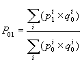
construction technologies) and the types of engineering
structures with similar criteria, which form the value, shall be
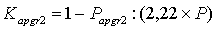
joined in groups of engineering structure types (Annex 2).
7. The State Land Service shall develop value zoning for
specification of base indicators of cadastral values. Zoning is
the division of the State territory into value zones for the
relevant group of immovable property, in which the value of
mutually comparable immovable properties is relatively similar in
the market of immovable property.
8. The group of immovable property shall be determined taking
into account the purposes of use and type of building in
accordance with Annex 3 to these Regulations.
9. Zoning of one group of immovable property (hereinafter -
zoning) shall be developed once in four years in the entire
territory of the State concurrently and in the following
order:
9.1. for the group of rural immovable properties - utilised
agricultural land zoning and wooded land zoning ;
9.2. for the groups of building immovable properties:
9.2.1. for the group of residential building immovable
properties - zoning for the building of residential houses;
9.2.2. for the group of industrial building - zoning for the
building of industrial production objects; and
9.2.3. for the group of commercial activities and public
building - zoning for commercial object building.
10. Base values of engineering structures shall be determined
concurrently with the development of zoning for the group of
industrial building.
11. The following shall be used for the development of
zoning:
11.1. immovable property market information (information
regarding purchases, lease, construction costs, immovable
property market offer and demand, immovable property market
activity);
11.2. information regarding the main factors affecting the
value of immovable property, which has been obtained by analysing
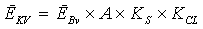
the market prices of immovable properties;
11.3. the territorial local government spatial plans and
detailed plans;
11.4. the information regarding special areas of conservation
and borders thereof specified in regulatory enactments; and
11.5. for mutual comparison of local governments -
socio-economic development indicators of local government (for
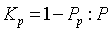
example, the amount of income tax per one inhabitant,
unemployment rate, number of economically active inhabitants,
demographic load).
12. The borders for value zones of the building immovable
property shall be determined in accordance with the borders of
units of land, not allowing the separation of a unit of land and
building into different value zones (except for the units of land
under roads, railways, rivers). The borders for value zones of
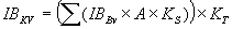
zoning of the group of rural immovable property shall be
determined in accordance with the borders of local government
administrative territory or the borders of territorial unit
counties and towns with a rural area (hereinafter - local
government territory).
13. The zone number of zoning values shall be unique. The zone
number for the group of building immovable property shall consist
of the zoning designation code, administrative territorial unit
classification code and zone order number in the local government
territory. The zone number of zoning values for the group of
rural immovable properties shall consist of the zoning
designation code, administrative territorial unit classification
code and group order number of the value level.
14. Zoning designation codes are the following:
14.1. utilised agricultural land zoning -1;
14.2. wooded land zoning - 2;
14.3. zoning for residential house building - 3;
14.4. zoning for the building of industrial production objects
- 4; and
14.5. zoning for commercial object building - 5.
15. Base indicators of cadastral values for immovable property
shall be determined within the limits of the value zone:
15.1. specified in Sub-paragraphs 19.1, 19.2, 19.3, 26.1,
26.2, 41.1, 41.2, 41.3 and 49.1 of these Regulations -
concurrently with the development of zoning for the relevant
group or property;
15.2. the market correction coefficients specified in
Sub-paragraph 19.4, 26.3, 41.1 and 49.2 of these Regulations:
15.2.1. for the group of industrial building immovable
properties - zoning for the utilised agricultural land and wooded
land zoning in the year of development;
15.2.2. for the group of commercial activity and public
building immovable properties - zoning for the building of
residential houses in the year of development;
15.2.3. for the group of rural immovable properties - zoning
for building of industrial production objects in the year of
development; and
15.2.4. for the group of residential building immovable
properties - zoning for the building of commercial objects in the
year of development.
16. In developing land value zonings, the State Land Service
shall co-operate with local governments:
16.1. together with responsible representatives (consultants)
assigned by local governments shall assess the designed borders
of the value zones; and
16.2. after development of the draft zoning, but not later
than two weeks prior to the application of the base of cadastral
values for announcement in the meeting of State Secretaries shall
submit a zoning map (if there is more than one zone in the
relevant local government) and tables of the value base
indicators to the local government for provision of an
opinion.
17. After the approval of the zoning and base of cadastral
values in the Cabinet, the State Land Service shall:
17.1. register the zoning and base of cadastral values in the
Cadastre information system;
17.2. ensure the accessibility to information by placing the
zoning and tables for base of cadastral values on the Internet
home page of the State Land Service (www.vzd.lv); and
17.3. submit the graphic material of the zoning of the
relevant local government to the local government, if in the
territory of the local government there is more than one
zone.
18. Local government shall ensure the accessibility of the
submitted graphic material of the zoning for each person
interested in it.
III.
Development of the Base of Cadastral Values for Building
Land
19. The indicators of the base of cadastral values for
building land shall be:
19.1. the land base value;
19.2. the land standard area (hereinafter - standard
area);
19.3. the correction coefficient of the standard area; and
19.4. the correction coefficient of market changes.
20. Land base value is the value of one square meter of the
land in lats within the value zone for a particular purpose of
use, and it is determined in accordance with the information of
the immovable property market.
21. Land standard area is the relative area of the unit of
land, which has been specified by analysing the immovable
property market for the needs of calculation of the land
cadastral value for a particular group of purposes (purpose) of
use and the price of which characterises the most characteristic
price level of units of land in terms of area in a particular
territory for the appropriate group of purposes (purpose) of
use.
22. The correction coefficient of the standard area shall be
determined, taking into account the ratio between the price for
one square metre for the units of land, which comply with the
standard area, and the price for one square metre for the units
of land, which exceed the standard area.
23. Transactions with land, the area of which does not exceed
the size specified by the standard area for more than 20%, shall
be used for the specification of the base value of the land use
purposes, for which a standard area is specified.
24. In value zones, where the number of transactions within
the relevant group of purposes of use is less than five, the base
values of the land shall be determined in comparison with other
value zones, taking into account the factors affecting the value
of the building land (for example, engineering support, social
infrastructure development level, engineering-geological
conditions, the character and intensity of the present building),
as well as the indicators of socio-economic development of local
government referred to in Sub-paragraph 11.5 of these
Regulations.
25. One base value shall be determined for the land of the
purpose for use "Land in the territories of railway
infrastructure right of way and in the territories of road right
of way" in all value zones within the local government
territory.
IV. Development
of the Basis of Cadastral Values for Rural Land
26. The indicators of the basis of cadastral values for rural
land shall be:
26.1. the base value for the utilised agricultural land for
each quality group of the utilised agricultural land;
26.2. the base value for wooded land for each quality group of
wooded land; and
26.3. the correction coefficient of market changes.
27. Utilised agricultural land depending on the quality
assessment in points of the utilised agricultural land by the
regulatory productivity (one land value point - 70 kg of rye
units) shall be divided in six quality groups:
27.1. I quality group - less than 20 points;
27.2. II quality group - from 20 up to 30 points;
27.3. III quality group - from 31 up to 40 points;
27.4. IV quality group - from 41 up to 50 points;
27.5. V quality group - from 51 up to 60 points; and
27.6. VI quality group - more than 60 points.
28. The following main factors affecting the value shall be
assessed in respect to the rural land:
28.1. the land quality;
28.2. the content of the use types of land;
28.3. the area;
28.4. the location;
28.5. the building effect; and
28.6. encumbrances.
29. Local government territories shall be joined in the groups
of value levels for the specification of the base values for the
utilised agricultural land. Local government territories with a
similar price level of III quality group of the utilised
agricultural land shall comply with the group of one value level
of the utilised agricultural land.
30. Local government territories, where the number of
transactions with the utilised agricultural land is less than
five, the belonging to a particular group of the value level
shall be determined in comparison with the local government
territories for which the levels for land prices are specified,
assessing the main factors affecting the value of the utilised
agricultural land referred to in Paragraph 28 of these
Regulations and the indicators of socio-economic development of
local government referred to in Sub-paragraph 11.5. of these
Regulations.
31. The base value of the utilised agricultural land shall be
determined in lats per hectare for all the quality groups of the
utilised agricultural land for each local government territory,
except for the territories of towns.
32.One base value of land shall be determined in the territory
of a town (without the assessment of land quality groups) for all
purposes of use from the group of purposes of use "Agricultural
land" and "Land of water bodies". The base value for land shall
be specified taking into account the highest base value, which is
specified in the territories of rural local government, which
border the relevant town. The base value of the utilised
agricultural land in the territory of towns shall be determined
in lats per square metre.
33. The following main factors affecting the value of wooded
land shall be analysed for the specification of the base value
for wooded land:
33.1. the quality of wooded land depending on the type of
growth conditions of the forest;
33.2. felling restrictions;
33.3. buying-in prices for timber;
33.4. the location in relation to the timber market and
processing centres; and
33.5. the road infrastructure.
34. Quality groups of wooded land in accordance with the
average quality assessment in points of wooded land (average
growth of the standing volume - one cubic metre per year on one
hectare - is equalled to seven points of land value) shall be
divided in the following groups:
34.1. I quality group - less than 10 points;
34.2. II quality groups - from 10 up to 20 points;
34.3. III quality group - from 21 up to 35 points; and
34.4. IV quality group - from 36 up to 50 points.
35. The level of the average value for wooded land shall be
determined in accordance with the types of forest growth
conditions using the income capitalisation method, as well as
taking into account:
35.1. the net income from the final felling in accordance with
the information regarding the average liquid wood yield in the
forest stands that have reached the age of the main felling in
division by the leading tree species;
35.2. the average age of the final felling complying with the
type of the forest growth conditions; and
35.3. the average forest management expenses for one
hectare.
36. Net income depending on the type of forest growth
conditions shall be determined on the basis of the information
which is prepared by the Central Statistics Bureau in
co-operation with the Ministry of Agriculture:
36.1. regarding the average prices in lats for round timber
per one cubic metre in division by tree species and timber
assortment;
36.2. regarding the average output expenses for the final
felling;
36.3. regarding reforestation and maintenance expenses;
and
36.4. regarding administration expenses.
37. The average level of value for the quality group of the
relevant wooded land shall be determined from the levels of land
values of the types of the forest growth conditions appropriate
to the relevant quality group of the wooded land.
38. Local government territories shall be joined in the groups
of value levels for the determination of the base values of
wooded land:
38.1. the location of the relevant local government territory
in relation to the timber market and processing centres;
38.2. the difference of the selling prices for growing trees
by territories;
38.3. the differences in transportation expenses;
38.4. the socio-economic development indicators of local
government referred to in Sub-paragraph 11.5 of these
Regulations; and
38.5. the level of values for the utilised agricultural
land.
39. The base value for wooded land shall be determined for
each quality group of the wooded land, by analysing the level of
values of the wooded land and the criteria referred to in
Paragraph 38 of these Regulations.
40. One base value for land shall be determined in the town
territory (without assessment of the quality groups of the wooded
land) for all use purposes from the group of purposes "Forestry
land and special areas of conservation in which economic
activities are prohibited by regulatory enactment". The base
value shall be specified taking into account the highest base
value, which is specified in the territories of the rural local
government, which borders the relevant town. The base value for
the wooded land in the territory of towns shall be determined in
lats per square metre.
V. Development
of the Basis of Cadastral Values for Buildings
41. The indicators of the basis of cadastral values for
buildings shall be:
41.1. the base value of the building type;
41.2. the standard volume of the building (most widespread
volume interval of the relevant building type, within the limits
of which the directly proportional regularity remains between the
unit price of the building and changes in volume);
41.3. the correction coefficient of volume; and
41.4. the correction coefficient of market changes.
42. The base value of the building type is the value in lats
per one volume unit of the building specified in accordance with
the immovable property market information within the particular
value zone. The base value of the building type shall be
determined taking into account the building of the relevant
type:
42.1. the value level (the average market price for one unit
of a particular type of building within a separate territory -
market region, the borders or which does not divide the territory
of the local government and in which the market indictors of
immovable property are mutually comparable and equal); and
42.2. the average market price for one unit within the value
zone or within the group of value zones with equal price levels
of land of the relevant immovable property group and factors
affecting the value of the relevant types of buildings.
43. Market regions of buildings shall be determined by the
groups of building types for specification of the value level of
the building type using the integrated analysis of:
43.1. the average market price for one unit of the buildings
complying with the relevant group of building types by building
types within the territory of local government;
43.2. the price levels of the land of the relevant immovable
property group;
43.4. the indicators of the socio-economic development of the
local government specified in Sub-paragraph 11.5. of these
Regulations; and
43.4. the indicators affecting the value of building
types.
44. The market price for one unit of the building within the
composition of the transaction object of the immovable property
shall be calculated:
44.1. by subtracting the cadastral value of the land from the
total amount of the transaction and assuming that the division
between buildings is directly proportional to the ratios of the
cadastral values of the buildings; and
44.2. by dividing the market price of the building by the
volume indicator complying with the building type (if the
measurement complying with the building type is cubic metres -
with building volume, if square metres, - by the total area of
the building) and the correction coefficient of the physical
state of the building.
45. The standard volume of the building shall be determined
for building types which have significant differences in the
average price of one unit for different building volumes, on the
basis of analysis of the immovable property market
information.
46. Transactions with buildings of the relevant type, which do
not exceed the standard volume, shall be used for the
specification of the base values for a building type, for which
the standard volume has been specified.
47. Information regarding direct construction costs (the
average expenses in lats per volume unit for construction and
installation work of a particular building type, where expenses
related to improvement of the territory, external engineering
networks and installation of devices are not included), taking
into account construction costs of a building type and the
average price level of the relevant group of building types in
the State.
48. The volume correction coefficient shall be determined by
analysing the immovable property market information, assessing
the mutual coherency of the unit price between buildings of the
one type, which by volume do not exceed the standard volume, and
buildings which by volume exceed the standard volume in the
relevant market region.
VI. Development
of the Basis of Cadastral Values of Engineering Structures
49. The base indicators of cadastral values for engineering
structures shall be:
49.1. the base value of the engineering structure type;
and
49.2. the correction coefficient of market changes.
50. The base value of the engineering structure type shall be
determined by analysing:
50.1. information regarding direct construction costs for the
engineering structure;
50.2. the indexes for costs of construction published by the
Central Statistics Bureau and the summary average prices of
construction resources; and
50.3. the ratio of the direct construction costs and the
average State price level of the group of buildings of the
industrial type.
51. The base values of engineering structure types approved by
Cabinet Regulation No. 19 of 3 January 2006, Regulations
Regarding Basis of Cadastral Values shall be used for the
specification of base values for engineering structure types
regarding which the information referred to in Sub-paragraph 50.1
of these Regulations is not available, by indexing them by the
indexes of construction costs specified by the Central Statistics
Bureau.
VII.
Specification of the Correction Coefficient of Immovable Property
Market Changes
52. The correction coefficient of immovable property market
changes shall be determined for a group of immovable property
based on the information accumulated in the immovable property
market database regarding transactions of purchase of immovable
property.
53. The following shall be used for the specification of the
correction coefficient ( KT) of immovable
property market changes:
53.1. indexes of price changes of immovable property market
(hereinafter - price index);
53.2. the indicators of socio-economic development of the
local government specified in Sub-paragraph 11.5. of these
Regulations; and
53.3. the range of changes of value basis indicators developed
in the relevant year.
54. The price index shall be calculated using the following
formula:
 |
, where |
 - the price index;
 - the average amount in lats of the transaction
within the reference period in the i-group of transaction
objects;
- the average amount in lats of the transaction
within the reference period in the i-group of transaction
objects;
 - the average amount in lats of the transaction
within the base period in the i-group of transaction objects;
- the average amount in lats of the transaction
within the base period in the i-group of transaction objects;
 - the number of transactions within the base
period in the i-group of transaction objects; and
- the number of transactions within the base
period in the i-group of transaction objects; and
i - the group of transaction objects, where there are
transactions in both the base and reference periods.
55. The reference period is two years. The date of
commencement of the reference period shall be 1 January
(including) of the year of approval of the zoning and relevant
base indicators of the cadastral values of the immovable
property.
56. The base period is two years. The date of ending of the
base period is 1 January (not including) of the year of approval
of the zoning and relevant base indicators of cadastral values of
the immovable property.
57. Transactions shall be divided into the groups of
transaction objects, taking into account the composition of the
transaction object, the purpose of use and the values
characterising the object (area, building volume):
57.1. for transactions with the purpose of use "Individual
Residential House Building":
57.1.1. transactions with land, when the area of land is less
than or equal to 3 000 square metres;
57.1.2. transactions with building properties, when the area
of land is less or equal to 3 000 square metres and the area of
the residential house is more than 80 square metres and less than
160 square metres;
57.2. for transactions with apartments when the total area is
larger than 40 square metres and less than 70 square metres;
57.3. for transactions with the purpose of use from the group
of purposes of use "Land for Building of Objects of Commercial
Activities":
57.3.1. transactions with land when the land area is larger
than 1 000 square metres and less than 5 000 square metres;
57.3.2. transactions with land and building properties when
the area of land is greater than 1 000 square metres and less
than 5 000 square metres and the total area of buildings of
transaction institutions and buildings of a commercial nature is
greater than 800 square metres and less than 2 000 square
metres;
57.4. for transactions with the purpose of use from the group
of purposes of use "Land for Building of Industrial Objects":
57.4.1. transactions with land when the land area is larger
than 1 000 square metres and less than 10 000 square metres;
57.4.2. transactions with land and building properties when
the area of land is greater than 1 000 square metres and less
than 10 000 square metres and the total area of industrial
buildings is greater than 80 square metres and less than 300
square metres;
57.4.3. transactions with land and building properties when
the area of land is greater than 1 000 square metres and less
than 10 000 square metres and the total area of industrial
buildings is greater than 300 square metres and less than 1 000
square metres;
57.4.4. transactions with land and building properties when
the area of land is greater than 1 000 square metres and less
than 10 000 square metres and the total area of industrial
buildings is greater than 1 000 square metres and less than 3 000
square metres;
57.5. for transactions with the purpose of use "Land where the
Main Economic Activity is Agriculture":
57.5.1. transactions with land when the land area is larger
than 5 hectares and less than 15 hectares; and
57.5.2. transactions with land and building properties when
the area of land is greater than 1 hectare and less than 5
hectares and the total area of the residential house is greater
than 80 square metres and less than 160 square metres.
58. Such groups of transaction objects shall be used for the
calculation of the price index in which there are at least five
transactions in each period and the number of groups is at least
three.
59. Price indexes shall be calculated for all the territory of
the State and by the groups of local government territories,
joining in one group all the local government territories, where
the maximum land base value for the purpose of use "Individual
Residential House Building" is:
59.1. less than or equal to LVL 0.50 per square metre;
59.2. larger than LVL 0.50 per square metre and less than or
equal to LVL 1.00 per square metre;
59.3. larger than LVL 1.00 per square metre and less than or
equal to LVL 3.00 per square metre;
59.4. larger than LVL 3.00 per square metre and less than or
equal to LVL 10.00 per square metre;
59.5. larger than LVL 10.00 per square metre and less than or
equal to LVL 20.00 per square metre; and
59.6. larger than LVL 20.00 per square metre.
60. The correction coefficient of changes in the immovable
property market shall be determined by comparing the price index
specified for the local government territory with the price index
in the State and taking into account the indicators of
socio-economic development of local government referred to in
Sub-paragraph 11.5 of these Regulations.
VIII. General
Issues of Calculation of Cadastral Value
61. In accordance with the approved zonings of immovable
property groups a number of the value zone of the relevant
zonings shall be determined for a unit of land.
62. If the adjacent unit of land or a part thereof, which is
located in different value zones, is added to the unit of land
after the approval of zoning, as the value zone of the unified
unit of land shall be determined such value zone, in which the
larger part of the area of the unit of land is located.
63. The appropriate value zone for a unit of land, which in
accordance with Paragraph 12 of these Regulations may be crossed
by the border of the value zone, shall be determined by taking
into account in which value zone the larger part of the area of
the unit of land is located.
64. The following shall be used for the calculation of the
cadastral value of the unit of land and a part of the unit of
land:
64.1. in rural area territories:
64.1.1. the formula for calculation of the value of rural
land, if the purposes of use for the rural land have been
registered in the Cadastre Information System;
64.1.2. the formula for calculation of the value of building
land, if the purposes of use corresponding to the building land
have been registered in the Cadastre Information System;
64.1.3. the formula for calculation of the value of rural land
and a formula for calculation of the value of building land, if
the purposes of use corresponding to both rural and building land
have been registered in the Cadastre Information System; and
64.2. in town territories - the formula for calculation of the
value of building land regardless of the purpose of use
registered in the Cadastre Information System.
65. The encumbrances registered for a unit of land shall be
assessed:
65.1. in a rural area territory:
65.1.1. as for the rural land of the rural area, if the
purposes of use corresponding to the rural land have been
registered in the Cadastre Information System;
65.1.2. as for the building land, if the purposes of use
corresponding to the building land have been registered in the
Cadastre Information System;
65.1.3. as for the rural land of the rural area and as for the
building land, if the purposes of use corresponding to both rural
and building land have been registered in the Cadastre
Information System; and
65.2. in a town territory - as for building land regardless of
the purpose of use registered.
66. An encumbrance correction coefficient, which is specified
for a unit of land in accordance with these Regulations, shall be
applied in the assessment of encumbrances for the part of the
unit of land.
67. If the drainage state or forest information has been
changed or soil pollution has been detected in a unit of land or
in a part of the unit of land , then, in order to re-calculate
the cadastral value, prior to the receipt of the information in
accordance with the procedures specified in regulatory enactments
from the holders of the relevant data, the cadastre subject may
submit:
67.1. for the specification of the cadastral value of the
rural land of a rural area:
67.1.1. the summary of the assessment prepared and issued by
the territorial office of the State Forest Service, if the wooded
land is registered in the unit of land;
67.1.2. a statement of the relevant territorial unit of the
Rural Support Service regarding the changes in the amelioration
system, if any detected;
67.1.3. a statement of the relevant regional environmental
board of the State Environmental Service, that the unit of land
is located in the polluted area; and
67.2. for the specification of the cadastral value of the
building land - a statement of the relevant regional
environmental board of the State Environmental Service, that the
unit of land is located in the polluted area.
68. A cadastral value shall be calculated with an accuracy of
up to one lat.
69. Documents of cadastral assessment shall be kept in the
cadastre file of the archive of the State Land Service.
IX. Calculation
of the Cadastral Value for Building Land
70. The following data registered in the Cadastre Information
System shall be used for calculation of the cadastral value for
building land:
70.1. the purpose for use of the unit of land and land area
under jurisdiction thereof;
70.2. encumbrances specified for the unit of land which affect
the value of land and land areas covered by them; and
70.3. the purpose for use of the part of the unit of land and
land area under jurisdiction thereof.
71. Encumbrances, which affect the value of building land,
shall be determined by analysing the restrictions on the rights
of use or restrictions on economic activity, expressed by the
relevant encumbrance, and assessing the immovable property market
information regarding the value of the unit of land with the
encumbrances specified and the value of the unit of land without
encumbrances.
72. Encumbrances for building land, taking into account the
restriction on the rights of use or restriction on economic
activity, shall be assessed in accordance with Annex 4 to these
Regulations:
72.1. regardless of the area covered by an encumbrance -
reducing the value of the unit of land by 20%, if the
encumbrances complying with Kapgr1
are registered in the Cadastre Information System; and
72.2. proportionally to the area covered by encumbrances -
reducing the value of the area burdened by 45%, if the
encumbrances complying with Kapgr2
are registered in the Cadastre Information System.
73. If the encumbrance complying with encumbrances
Kapgr2 specified in Annex 4 to these
Regulations is registered in the Cadastre Information System, but
the area covered is not registered, the cadastral value of the
unit of land shall be reduced by 1%.
74. The cadastral value for the area of a unit of land, for
which the encumbrance "Polluted Area" is registered, shall be
reduced by 100% up to the liquidation of the pollution.
75. The cadastral value for building land shall be calculated
using the following formula:
 |
, where |
Kv - the cadastral value in lats;
Bv - the base value of the building land in lats per
square metre;
PLM - the land area under jurisdiction of
the purpose of use in square metres;
Ksamaz - the area correction
coefficient;
KT - the correction coefficient of market
changes;
Kapgr - the correction
coefficient of encumbrances; and
Kp - the correction coefficient of
pollution.
76. The area correction coefficient ( Ksamaz
) shall be used for those areas under jurisdiction of the purpose
of use, which exceed the standard area, and shall be calculated
using the following formula:
 |
, where |
Ksamaz - the area correction
coefficient;
Pst - the standard area for the purpose of
use in the value zone in square metres;
PLM - the area under jurisdiction of the
purpose of use in square metres; and
Kst - the correction coefficient of the
standard value for the purpose of use in the value zone.
77. In determining the cadastral value of the unit of land,
the encumbrances registered in the Cadastre Information System
shall be assessed, by applying:
77.1. the encumbrance correction coefficient
Kapgr1 = 0.8; and
77.2. the encumbrance correction coefficient,
Kapgr2, which is calculated in
accordance with Paragraph 78 of these Regulations.
78. The encumbrance correction coefficient (
Kapgr2) shall be calculated, using
the following formula:
 |
, where |
Kapgr2 - the encumbrance correction
coefficient;
Papgr2 - the encumbrance area
(Papgr2 < P), which
complies with Kapgr2;
P - the total area in square metres of the unit of
land; and
2.22 - the numerical amount of 45% of deduction.
79. If encumbrances that are to be assessed differently have
been registered for the unit of land, the coefficient with the
lesser numerical amount shall be applied in the calculation of
the cadastral value of the land after the comparison of
(Kapgr1) and
(Kapgr2) coefficients.
80. In calculating the cadastral value for a unit of land, for
which an encumbrance "Polluted Area" has been registered in the
Cadastre Information System, the correction coefficient of
pollution (Kp) shall be applied, which shall be
calculated using the following formula:
 |
, where |
Kp - the correction coefficient of
pollution;
Pp - the polluted area in square metres;
and
P - the total area of the unit of land in square
metres.
81. The relevant regional environmental board of the State
Environmental Service shall, on the basis of the submission of
the cadastre subject, prepare and issue a statement, whether the
unit of land is located in the polluted area. The area of the
unit of land, which is located in the polluted area, shall be
indicated in the statement.
82. A cadastre subject shall submit the statement referred to
in Paragraph 81 of these Regulations to the relevant local
government. The local government shall notify the relevant
territorial office of State Land Service thereof within 10
days.
X. Calculation
of the Cadastral Value of the Rural Land of Rural Area
83. The following data of the unit of land registered in the
Cadastre Information System shall be used for calculation of the
cadastral value for the rural land of the rural area:
83.1. the purpose of use and division by types of use of land
for the land areas under jurisdiction thereof;
83.2. encumbrances which affect the land value and land areas
covered by them;
83.3. the quality assessment of the utilised agricultural land
in points; and
83.4. the quality assessment of wooded land in points.
84. The purpose of use of the unit of land and land area under
jurisdiction thereof registered in the Cadastre Information
System shall be taken into account in the calculation of the
cadastral value of the unit of land.
85. The State Land Service shall determine the division of the
land area under jurisdiction of the purpose of use by types of
use of land:
85.1. in accordance with the legend data of the unit of land,
if one purpose of use has been specified for the unit of land (a
part of the unit of land); and
85.2. in accordance with the statement issued by the local
government and graphical Annex regarding the division of the land
areas under jurisdiction of the purpose of use, if several
purposes of use have been specified for the unit of land (a part
of the unit of land).
86. The following types of use registered for the unit of land
or a part of the unit of land in the Cadastre Information System
shall be observed for the calculation of the cadastral value:
86.1. utilised agricultural land (cultivated soil, grassland,
pasture land, orchards);
86.2. wooded land;
86.3. land under buildings and courtyards;
86.4. land under fish ponds; and
86.5. other land (brushwood, marshes, land under waters
(except the land under fish ponds), land under roads and other
land indicated on the legend).
87. The quality assessment of the utilised agricultural land
in points shall be determined by the State Land Service by
normative productivity without exploration on site (office work),
using approved base maps of quality assessment for utilised
agricultural land or land quality assessment and soil mapping
materials.
88. The quality of utilised agricultural land in points shall
be determined for the unit of land as the weighted average
quality assessment. A quality assessment in points of the
utilised agricultural land specified for the unit of land shall
be applied to a part of the unit of land.
89. If, in assessing the information of the assessment base
map, it is determined, that non-utilised agricultural land has
been acquired in the unit of land to be assessed in comparison
with base the map or the amelioration situation has changed, or
the types of use of utilised agricultural land have been changed,
the assessment of the transformed land area quality shall be
adjusted using the land assessment tables and designations of the
soil type and mechanical content (Annexes 5, 6 and 7).
90. In the territories in which soil mapping has not been
performed and land quality assessment and soil mapping materials
have not been developed in accordance with it, the utilised
agricultural area quality assessment shall be determined as 20
points.
91. The State Land Service shall perform correction of the
base map of land quality assessment upon the request of the
cadastre subject at the requester's expense:
91.1. shall survey the territory on site and correct the land
quality assessment taking into account the effect of the factors
determined (for example, the amelioration state, the level of
overgrowth, flooding during the vegetation period, the amount of
stones, damages in the topsoil) in accordance with Annexes 5, 6
and 7 to these Regulations;
91.2. shall prepare the corrected land quality assessment map
and summary of the land quality assessment;
91.3. shall draw up the survey deed (in two copies), in which
the following shall be indicated:
91.3.1. the factors affecting the land quality assessment
determined;
91.3.2. the land quality assessment in points;
91.4. one copy of the deed shall be issued to the
commissioning party, the other - together with the land
assessment materials shall be attached to the cadastre file of
immovable property;
91.5. the corrected land quality assessment map shall be
attached to the archives file of the land quality assessment and
soil mapping materials; and
91.6. the corrected land quality assessment in points shall be
registered in the Cadastre Information System.
92. The State Forest Service shall determine the quality of a
unit of land for the wooded land in points in accordance with the
forest inventory materials, taking into account the type of
forest growth conditions (Annex 8) and restrictions on economic
activities. The State Forest Service shall provide information
regarding the assessment of forest land and value of the forest
stand in accordance with the procedures specified by regulatory
enactments.
93. A quality assessment in points of the wooded land
specified for the unit of land shall be applied to a part of the
unit of land.
94. If a forest stand has restrictions on economic activities
(restrictions on felling), the quality assessment of wooded land
shall be reduced:
94.1. by 100%, if the forestry activity or the final felling
is prohibited; and
94.2. by 50%, if the clear felling is prohibited.
95. The cadastral value for rural land shall be calculated
using the following formula:
 |
, where |
Kv - the cadastral value in lats;
PLIZ - the utilised agricultural land in
hectares;
Bvliz - the base value of the utilised
agricultural land zone in lats per hectare;
PM - the wooded land area in hectares;
BvM - the base value of the wooded land zone
in lats per hectare;
Pp_z - other land area in hectares;
P*p_D - the area in hectares of
the land under fish ponds and courtyards;
Bv*LIZ - the base value of the
utilised agricultural land of III quality group in lats per
hectare;
b - the feature of the residential house:
b=1, if there is a residential house on the unit of
land;
b=0, if there is no residential house on the unit of
land;
Cmaja - the constant of the affect of
residential house;
Kapgr - the correction coefficient of
encumbrances; and
Kp - the correction coefficient of
pollution; and
KT - the correction coefficient of market
changes.
96. The base value of the utilised agricultural land shall be
applied in accordance with the base value specified in the
relevant utilised agricultural land value zone for that quality
group, with which the quality assessment of the relevant unit of
land of utilised agricultural land complies.
97. In order to specify the value of the land under fish ponds
and courtyards, the base value of the relevant value zone shall
be applied to III quality group of the utilised agricultural
land.
98. The relevant value zone of III quality group of the
utilised agricultural land shall be applied for the specification
of other land value (except the land under fish ponds), applying
the coefficient 0.2.
99. The effect constant (Cmaja) of a
residential house shall be applied, if one purpose of use has
been specified for the unit of land and there is a building on
the unit of land from the group of the building type
"Single-family and Double-family Residential Houses". In such
case the base value of the land of the purpose of use "Individual
Residential House Building" shall be applied to 1 000
m2 land base value in accordance with the zoning of
the group of residential building.
100. If the area of the unit of rural land, for which in
accordance with Paragraph 99 of these Regulations the constant
(Cmaja) is applied, is less than 1 000
m2 , the land base value of the purpose of use
"Individual Residential House Building" shall be applied to the
total area of the whole unit of land. The numerical amount of the
effect of the residential house shall be calculated
proportionally to the area of a part of the unit of land in
relation to the total area of the unit of land.
101. The base value of the wooded land shall be applied in
accordance with the base value specified in the relevant wooded
land value zone for that quality group, with which the quality
assessment of the relevant unit of land of wooded land
complies.
102. If the information from the State Forest Service
regarding the quality assessment of the wooded land has not been
received, II quality group of wooded land shall be specified for
the wooded land. In such case the land cadastral value specified
in accordance with the Law on Land Privatisation in Rural Areas
shall not be used for doing transactions of land redemption.
103. If separate areas grown with trees do not exceed 0.1
hectare and the forest inventory is not performed therein in
accordance with the requirements of regulatory enactments, the II
quality group of forest land shall be specified for the forest
land.
104. For the unit of land for which the encumbrances specified
in Annex 4 to these Regulations have been registered except the
encumbrance "Polluted Area", the land cadastral value shall be
reduced:
104.1. by 5%, if the land area, which is covered by the
encumbrance, is not specified, or the area of encumbrances covers
up to 20% of the area of the unit of land;
104.2. by 10%, if the area of land encumbrances is covered by
21-40% of the area of land unit;
104.3. by 15%, if the area of land encumbrances is covered by
41-60 % of the area of the land unit;
104.4. by 20%, if the area of land encumbrances is covered by
61-80 % of the area of the land unit; and
104.5. by 30%, if the area of land encumbrances is covered by
81% and more of the area of the land unit.
105. In calculation of the land cadastral value for the unit
of land for which the encumbrance "Polluted Area" is registered,
the correction coefficient of pollution (Kp)
shall be applied, which is calculated in accordance with
Paragraph 80 of these Regulations. Pollution assessment and the
relevant opinion shall be prepared in accordance with Paragraph
81 of these Regulations.
XI. Calculation
of the Cadastral Value of a Building
106. The last cadastral survey data registered in the Cadastre
Information System (hereinafter - building data) shall be used in
the calculation of the cadastral value of a building:
106.1. the building type;
106.2. the indicator of the building volume;
106.3. the physical status; and
106.4. encumbrances.
107. The State Land Service shall determine the building type
in performing a cadastral survey in accordance with the documents
submitted by the initiator of the cadastral survey (building
design, a deed regarding the acceptance of the building into
service) taking into account its:
107.1. main type of use;
107.2. materials used for construction; and
107.3. technical indicators (number of above-ground storeys,
volume, material of the external walls).
108. The type applied to a building shall be changed, if the
main type of use of the building, material of the external walls,
number of storeys or other technical indicators have changed in
accordance with the cadastral survey information, which in
accordance with Annex 1 to these Regulations characterise the
building type.
109. The State Land Service shall perform the inspection of
the compliance of the building type upon the written request of
the building authority of the local government, building owner or
legal possessor.
110. The change of a building type shall be registered in a
deed regarding the change of the building type, which shall be
attached to the archive materials of the cadastral survey
file.
111. The correction coefficient of the physicals state of a
structure shall be determined, by analysing the information of
the immovable property market and assessing the changes of one
unit price depending on the physical state of the building. The
correction coefficient of the physical state of the structure
shall be determined in accordance with the percentage of the
physical status of the building (Annex 9).
112. Encumbrances for buildings in accordance with limitations
on the rights of use or restrictions on the effect of economic
activities shall be determined by analysing the information of
the immovable property market and assessing the mutual coherence
of one unit price between buildings without restrictions on use
and for buildings with restrictions on use. For a building which
is registered as a cultural monument of the State or local
significance, the cadastral value shall be reduced:
112.1. by 45%, if the building is registered as a cultural
monument of State significance; or
112.2. by 35%, if the building is registered as a cultural
monument of local significance.
113. The indicator of the building volume in the calculation
of cadastral value shall be selected taking into account the
measurement in which the base value of the building type is
expressed:
113.1. the total building volume - if the base value of the
building type is expressed in lats per cubic metre; and
113.2. the total area - if the base value of the building type
is expressed in lats per square metre.
114. The cadastral value of a building shall be calculated
using the following formula:
 |
, where |
ĒKV - the cadastral value in lats of the
building to be assessed;
ĒBv - the base value of the building type
complying with the building to be assessed in lats per indicator
of the volume;
A - the size of the volume indicator of the building to
be assessed in square meters or cubic metres;
KS - the correction coefficient of the
physical state of the structure;
Kkor - the correction coefficient of the
volume effect;
Kli - the encumbrance correction
coefficient; and
KT- the correction coefficient of market
changes.
115. The base value of the building type complying with the
building to be assessed (ĒBv) shall be
determined in accordance with the building type specified for a
particular building and the base value approved in the relevant
zone.
116. The correction coefficient of the physical state of the
structure (KS) for a building to be assessed
shall be determined using the percent of the physical state of
the building to be assessed registered in the Cadastre
Information System and the correction coefficient of the physical
state of the structure corresponding to it.
117. The correction coefficient of the volume effect
(Kkor) for buildings, the volume of which
exceeds the standard volume, shall be calculated using the
following formula:
 |
, where |
Kkor - the correction coefficient of the
volume effect;
A - the size of the volume indicator for the building
to be assessed in square metres or cubic metres;
Ast - the standard volume in square metres
or cubic metres; and
Kapj - the correction coefficient of
volume.
118. The correction coefficient of the volume effect
Kkor = 1 for buildings, which by volume do not
exceed the standard volume, or for a type of buildings, for which
a standard volume is not approved.
119. The encumbrance correction coefficient
(Kli) shall be applied to a building, for which
an encumbrance complying with the status of the cultural monument
of the State or local significance has been registered in the
Cadastre Information System in accordance with the information
provided by the State Inspection for Heritage Protection:
119.1. if the building has been registered as a cultural
monument of the State significance, Kli = 0.55;
and
119.2. if the building has been registered as a cultural
monument of local significance, Kli = 0.65.
120. Cadastral value of the group of premises shall be
calculated from the cadastral value of the building
proportionally to the area of the group of premises.
121. The cadastral value of the group of premises shall be
calculated using the following formula:
 |
, where |
TGKV - the cadastral value in lats of the
group of premises;
ĒKV - the cadastral value of a building,
where the group of premises is located;
TGkop.plat. - the total area of the group of
premises in square metres; and
Ēkop.plat. - the total area of the building
in square metres, where the group of premises is located.
122. The cadastral value of the group of premises shall be
re-calculated, if the cadastral value of the building, where the
group of premises is located, is changed.
XII.
Calculation of the Cadastral Value of an Engineering
Structure
123. The last cadastral survey data registered in the Cadastre
Information System (hereinafter - engineering structure data)
shall be used in the calculation of the cadastral value of an
engineering structure:
123.1. the engineering structure type;
123.2. the engineering structure volume indicator; and
123.3. the engineering structure physical state.
124. The engineering structure type, in performing the
cadastral survey, shall be determined by the State Land Service
in accordance with the documents submitted by the initiator of
the cadastral survey of the engineering structure (a building
design, a deed regarding acceptance of the structure into
service, executive surveys of engineering communications, a deed
of acceptance of works covered, a registration certificate of
engineering structure, a passport of engineering structure). In
determining the engineering structure type, the following shall
be taken into account:
124.1. its main type of use;
124.2. materials used for construction;
124.3. its technical indicators; and
124.4. its constructive solution.
125. The type applied to an engineering structure shall be
changed, if in accordance with the information of cadastral
survey the technical indicators have changed, which in accordance
with Annex 2 to these Regulations characterise the engineering
structure type.
126. An engineering structure may have two or more types and
two or more volume indicators, where each of them is attached to
a certain type of engineering structure and the base value of the
type.
127. An engineering structure type code and abbreviated name
of the engineering structure type shall be used for writing of
engineering structure type in the documents.
128. The standard depreciation of an engineering structure
shall be determined in accordance with the standard lifetime
specified in Annex 2 to these Regulations.
129. The cadastral value of an engineering structure shall be
calculated using the following formula:
 |
, where |
IBKV - the cadastral value of the
engineering structure in lats;
IBBv - the base value of the engineering
structure type;
A - the size of the volume indicators of the
engineering structure type to be assessed;
KS - the correction coefficient of the
physical state of the building; and
KT - the correction coefficient of market
changes.
130. The base value of the engineering structure type to be
assessed (IBBv) shall be determined in
accordance with the base value of the engineering structure type
approved in the value zone. The value zone shall be determined in
compliance with the value zone of building zoning of industrial
production objects where the unit of land, to which the
engineering structure is attached, is located.
The correction coefficient of the physical state of the
engineering structure (KS) to be assessed shall
be determined using the percent of the physical state of the
engineering structure to be assessed registered in the Cadastre
Information System and the correction coefficient of the physical
state of the structure specified in Annex 9 to these Regulations
corresponding to it.
XIII.
Calculation of the Cadastral Value of an Apartment Property
132. The cadastral value of a dwelling property shall be
calculated as an undivided share of the cadastral value of the
building, land and structures functionally connected, which are
included in the structure of the apartment property.
133. The cadastral value of the apartment property shall be
calculated using the following formula:
 |
, where |
DzĪKV - the cadastral value in
lats of the apartment property;
ZKV - the cadastral value of the unit of
land the undivided share of the joint property of which is
included in the structure of the apartment property;
(d/d)z - the undivided share of a joint
property of the unit of land the undivided share of the joint
property of which is included in the structure of the apartment
property;
ĒKV - the cadastral value of the building in
which the apartment property is located and the undivided share
of the joint property is not included in the composition of the
apartment property;
(d/d)B - the undivided
share of the joint property of the building in which the
apartment property is located and the undivided share of the
joint property of which is included in the composition of the
apartment property;
DzĪFSBKV - the cadastral values
of the structures functionally connected with the apartment
property, the undivided shares of the joint property of which are
included in the composition of the apartment property; and
 - the undivided share of the joint property of the
structure functionally connected with the apartment property, the
undivided share of the joint property of which is included in the
composition of the apartment property.
- the undivided share of the joint property of the
structure functionally connected with the apartment property, the
undivided share of the joint property of which is included in the
composition of the apartment property.
134. The cadastral value of the apartment property shall be
recalculated, if:
134.1. the cadastral value of such unit of land is changed,
the part of which is included in the composition of the apartment
property of the undivided share of the joint property;
134.2. the cadastral value of the building in which the
apartment property is located and the undivided share of the
joint property of which is included in the composition of the
apartment property or the cadastral value of the building
functionally connected with the apartment property is changed;
or
134.3. the undivided shares of the joint property included in
the apartment property are changed.
XIV.
Calculation of the Cadastral Value of a Tax Object
135. The quality assessment of such wooded land, which is
covered by renewed or cultivated forest stands (young stands),
shall not be included in the calculation of the cadastral value
of an immovable property tax object in accordance with the
procedures specified in regulatory enactments.
136. If a young stand is registered in the Cadastre
Information System within the composition of an immovable
property tax object located in the town territory, the cadastral
value of the immovable property tax object shall be reduced
proportionally by the area of the young stand in the relevant
unit of land.
137. If an immovable property tax object is a part of a
building, the cadastral value shall be calculated from the
cadastral value of the building proportionally to the area of the
tax object (building area subject to tax).
XV. Closing
Provisions
138. The following regulations are repealed:
138.1. Cabinet Regulation No. 465 of 19 December 2000,
"Regulations Regarding Cadastral Assessment of Urban Land"
(Latvijas Vēstnesis, 2000, No. 473/476; 2001, No. 154;
2003, No. 28; 2005, No. 95);
138.2. Cabinet Regulation No. 341 of 31 July 2001,
"Regulations Regarding Cadastral Assessment of Rural Areas Land"
(Latvijas Vēstnesis, 2001, No. 115, 182; 2003, No. 53;
2005, No. 95); and
138.3. Cabinet Regulation No. 184 of 30 April 2001,
Regulations Regarding Cadastral Assessment of Buildings"
(Latvijas Vēstnesis, 2001, No. 73; 2003, No. 77; 2004, No.
60; 2005, No. 95, 144).
139. The State Land Service shall calculate or recalculate the
historical cadastral value of a cadastre object and immovable
property tax object, what it actually was or might have been on a
certain date of the previous period, upon request on the basis of
adjudication of the court, taking into account:
139.1. the requirements of regulatory enactments in force and
the base indicators of cadastral values on the date of the
previous period indicated on the request; and
139.2. the data characterising the cadastre object and
immovable property tax object referred to in the request, as well
as the data registered in the Cadastre Information System on the
specified date as far as they are not in contradiction with the
data referred to in the request.
140. The State Land Service is entitled to calculate the
cadastral value foreseen for a cadastral object upon request,
taking into account:
140.1. the base indicators of cadastral values approved for
the next year; and
140.2. the data characterising the cadastre object which are
registered in the Cadastre Information System as of the date of
the calculation of the value.
141. In order to ensure the transition to the development of
the cadastral value base for the group of immovable property
concurrently in the entire territory of the State, the State Land
Service shall develop:
141.1. in 2007 - zoning for utilised agricultural land, zoning
for wooded land and the cadastral value base for the group of
rural immovable properties;
141.2. in 2007 - zoning for building of residential houses,
the cadastral value base for the group of residential building
immovable properties and correction coefficients of immovable
property market changes for the group of immovable properties of
commercial activity and public building, as well as for the group
of immovable properties of industrial production;
141.3. in 2008 - zoning for building of industrial production
objects, the cadastral value base for the group of immovable
properties of industrial building and the correction coefficient
of market changes for the group of rural immovable properties;
and
141.4. in 2009 -zoning for commercial objects, the cadastral
value base for the group of immovable properties of commercial
activity and public building and shall determine the correction
coefficient of market changes for the group of immovable
properties of residential building.
142. Up to the coming into force of the zonings for the
relevant group of immovable properties, the zone borders and
correction coefficient of market changes shall be determined in
accordance with the approved zonings of urban land values or
zonings of rural building land values.
143. The State Land Service shall use the zonings of urban
land values and zonings of rural building land values, the
development of which has been initiated up to 15 September 2005
in accordance with the procedures specified in regulatory
enactments, for the development of the zonings of the relevant
groups of immovable properties in compliance with the
requirements of these Regulations.
144. In order to ensure the transition to calculation of
cadastral values of buildings in accordance with Paragraph 114 of
these Regulations, the State Land Service shall develop in
2006:
144.1. the standard volume of building types and volume
correction coefficients in accordance with Paragraph 45 and 48 of
these Regulations; and
144.2. the base values of building types in accordance with
Paragraph 42 of these Regulations.
145. The coefficients to be used in the calculation of the
cadastral value of a building specified in Paragraph 114 of these
Regulations - the correction coefficient of the volume effect (
Kkor ) and correction coefficient of
encumbrances (Kli) - shall come into force on 1
January 2007.
146. The land cadastral values shall be calculated in
accordance with the following procedures up to 1 January 2008 for
units of land and parts of a unit of land in rural areas, for
which the purpose of use has been specified from the group of the
purposes of use "Rural Land", "Forestry Land and Special Areas of
Conservation where Economic Activity is Prohibited by Regulatory
Enactment" and "Land of Water Bodies", as well as the purpose of
use has been specified "Building of Structures for Rivers and
Channels, Water Accumulation, Water Adjustment and Bank Fixing"
or "Territories of Nature Base, Parks, Green Area and Other
Objects of Recreation Significance":
146.1. the cadastral value of land shall be calculated using
the following formula:
 |
, where |
Kv - the cadastral value of the unit of land in
lats;
PLIZ - the utilised agricultural land in
hectares;
VKVAL - the quality assessment of the
utilised agricultural land in points;
PPAG - the area in hectares of the land
under buildings and courtyards;
PPAR - the other land area in hectares;
PDIKI - the area in hectares of the land
under fish ponds;
K1 - the inter area coefficient;
K2 - the location coefficient;
PM - the wooded land area in hectares;
VMVID - the average assessment of the
cadastral territory of wooded land in points per hectare;
VM - the quality assessment of wooded land
in hectare points;
KM - the location coefficient of wooded
land;
3,171 - the value in lats of one hectare point;
Kapgr - the correction coefficient of
encumbrances;
Kp - the correction coefficient of
pollution;
146.2. the quality assessment of the land under buildings and
courtyards shall be 50 points;
146.3. the quality assessment of the land under brushwood,
marshes, waters and roads (except fish ponds) and other land
shall be 8 points;
146.4. the quality assessment of the land of fish ponds -
bodies of water installed artificially for fish farming - shall
be 35 points;
146.5. the quality of wooded land shall be assessed using the
information provided by the State Land Service which is included
in the summary of the wooded land assessment;
146.6. if the information has not been received form the State
Land Service regarding the quality assessment of the wooded land,
the average assessment of the cadastral territory of wooded land
shall be used for the specification of the wooded land quality
(Annex 10). In such case the land cadastral value specified shall
not be used for performing transactions connected with the land
value;
146.7. if separate areas covered with trees are less than 0.1
ha and the forest inventory has not been performed therein, their
value shall be determined in accordance with the average
assessment of the cadastral territory of the wooded land (Annex
10). A cadastral territory is a territory drawn in the graphical
part of the cadastre, which complies administratively with the
territorial division by the status as of 1 May 1996;
146.8. the quality assessment of rural land shall be corrected
by the inter area coefficient K1 (Annex 11).
The inter area coefficient K1 shall not be
applied to forest land;
146.9. the quality assessment of rural land shall be corrected
by the location coefficient K2 (Annex 12 and
13). The location coefficient of wooded land KM
shall be applied to wooded land (Annex 10). The average location
coefficient of the cadastral territory shall be applied in the
calculation of the cadastral value for other land present in the
State Forest Fund (Annex 10);
146.10. the inter area and location coefficient shall be
determined using the approved location correction map of the
State Land Service in accordance with the road surfacing and
correction coefficients which characterise the location of the
unit of land in respect of other towns (Annex 11), in respect of
the centre of the cadastral territory and another populated area
of the cadastral territory or town (Annex 12); and
146.11. the cadastral value of land shall be reduced in
accordance with Paragraphs 104 and 105 of these Regulations for a
unit of land for which encumbrances have been registered.
147. The land base value for units of land, for which the
purpose of use "Use of Land for Gardens Permitted Temporary"
and/or "Nature Territories Equipped for Sports and Recreation"
has been specified, up to 1 January 2010 shall be determined in
the following way:
147.1. in Riga - as for the purpose of use "Land where the
Main Economic Activity is Forestry";
147.2. in other cities - as for the purpose of use "Land where
the Main Economic Activity is Agriculture"; and
147.3. in a rural area - as for the purpose of use "Building
of Undertakings of Agricultural Nature".
[19 December 2006]
148. The cadastral value of a building shall be calculated
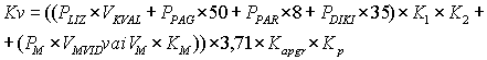
using the following formula up to 1 January 2007:
 |
, where |
ĒKV - the cadastral value in lats of the
building to be assessed;
ĒBv - the base value of the building type
complying with the building to be assessed in lats per indicator
of the volume;
A - the size of the volume indicator for the building
to be assessed in square metres or cubic metres;
KS - the correction coefficient of the
physical state of the building; and
KT - the correction coefficient of
market.
149. The basic value of the building type complying with the
building to be evaluated (ĒKV) shall be
determined in accordance with the building type specified for a
particular building and the basic value approved.
150. The market correction coefficient (KCL
) complying with the building to be assessed shall be determined
by the approved market correction coefficient for the complying
type of building within the territory of a particular local
government, taking into account the location of the building to
be assessed.
151. For buildings, for which in accordance with the opinion
provided by the building authority up to the coming into force of
these Regulations:
151.1. the building type "Individual Residential Houses with
Stone and Stone-Wooden External Walls for which Construction
Works have been Performed in Improved Quality and with Special
Improvement Elements after 1992" has been specified, starting
from 1 January 2007 the type "Individual Residential Houses and
Summer Cottages with Stone and Stone-Wooden External Walls" shall
be specified;
151.2. the building type "Hotel Buildings the Construction
Works or Reconstruction of which have been Performed in Improved
Quality after 1992 and which Comply with the Category of at least
Five Star Hotel by the Level of Services Provided" has been
specified, starting form 1 January 2007 the type "Hotel
Buildings" shall be specified; and
151.3. the building type "Buildings of Bank Establishments for
which Construction Works have been Performed in Improved Quality
and with Special Improvement Elements" has been specified,
starting form 1 January 2007 the type "Bank Establishments" shall
be specified.
152. Up to the development and approval of building zoning of
industrial production objects the base value of the engineering
structure type to be assessed (IBBv) shall be
determined in accordance with the base value of the engineering
structure type approved for the relevant engineering structure
type, which is specified as the average value of the building
costs for the relevant type in the State.
153. Annex 2 to these Regulations shall come into force from 1
January 2007, up to this date the engineering structure types
shall be determined in accordance with Annex 14 to these
Regulations.
154. Up to the forerun of the encumbrance classification
(Annex 4) in the Cadastre Information System, but not later than
up to 1 January 2007, the correction coefficient of encumbrances
for the calculation of the land cadastral value shall be
determined in accordance with Annex 15 to these Regulations.
Prime Minister A. Kalvītis
Minister for Justice G.Grīnvalds
Translation © 2007 Tulkošanas un terminoloģijas
centrs (Translation and Terminology Centre)