|
Text consolidated by Valsts valodas centrs (State
Language Centre) with amending laws of:
7 October 2010 [shall come
into force on 3 November 2010];
16 December 2010 [shall come into force on 1 January
2011];
10 December 2020 [shall come into force on 5 January
2021].
If a whole or part of a section has been amended, the
date of the amending law appears in square brackets at
the end of the section. If a whole section, paragraph or
clause has been deleted, the date of the deletion appears
in square brackets beside the deleted section, paragraph
or clause.
|
The Saeima1 has adopted and
the President has proclaimed the following law:
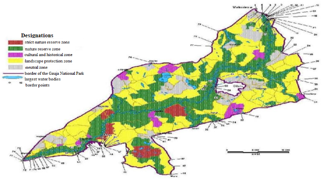
Gauja National Park Law
Chapter I
General Provisions
Section 1.
(1) Gauja National Park (hereinafter - the Park) is a
specially protected nature territory of national significance
that is located in the ancient Gauja River valley and its
vicinity. Borders of the Park have been determined in accordance
with the scheme of borders of the Gauja National Park (Annex 1)
and the description of borders of the Gauja National Park (Annex
2).
(2) The Park shall be administered by the Nature Conservation
Agency (hereinafter - the Agency) that is an institution of
direct administration subordinate to the Minister for
Environmental Protection and Regional Development.
[16 December 2010]
Section 2.
(2) The purpose of the Law is to protect the lightly touched
nature territories of the Park that are characterised by huge
biological diversity, the rock outcrops, terrain forms, boulders,
springs (hereinafter - the geological and geomorphological nature
monuments of national and local significance), and also the
typical landscapes, nature and cultural monuments, and to promote
nature tourism and sustainable development of the territory.
(2) The Cabinet shall approve the areas of functional zones of
the Park and the descriptions of borders thereof.
(3) The Cabinet shall issue regulations governing individual
protection and use of the Park.
Section 3.
(1) It shall be prohibited within the territory of the Park
to:
1) damage or destroy cultural and historical objects;
2) damage or destroy geological and geomorphological nature
monuments of national and local significance;
3) perform activities which cause soil erosion;
4) damage or destroy micro-reserves, specially protected
biotopes, specially protected species and their habitats;
5) damage or destroy specially protected trees which are
included in the category of natural monuments;
6) damage or destroy protected trees of local significance the
list of which is approved by local governments;
7) damage bird nesting sites, anthills, and homes of other
animals;
8) dump or discard waste, except for landfill sites and waste
dumps;
9) straighten rivers and streams;
10) move along rivers, lakes, and other water bodies by
motorboats, personal watercraft, and other means of water
transport operated by engines of any type and capacity. This
prohibition shall not apply to the movement of officials of State
and local government authorities while performing their office
duties, and also to the movement by water transport on the Lake
Ungurs;
11) damage or destroy objects for the improvement of nature
tourism and information infrastructure and informative and
instruction signs;
12) build dams and artificial obstacles without installing
fish passes on rivers and other watercourses where fish migration
takes place, except for the cases where it is necessary for the
protection and preservation of ecosystems, specially protected
species, and specially protected biotopes.
(2) Movement by motorboats, personal motorcraft, and other
means of water transport operated by engines of any type and
capacity shall only be permitted on the Lake Ungurs with a
written permit of the Agency.
(3) Any activities causing pollution of soil, air, surface
water bodies, springs, and groundwaters within the territory of
the Park shall only be permitted provided that requirements of
the laws and regulations regarding pollution are complied
with.
[7 October 2010]
Section 4.
(1) It shall be permitted with a written permit of the Agency
to:
1) extract mineral resources, except for the extraction of
groundwater for personal use;
2) perform scientific and archaeological research work and
explore subterranean depths;
3) transform forest land in accordance with the laws and
regulations regarding land transformation and change the category
of use of agricultural land;
4) use motorised means of water transport in the Lake
Ungurs.
(2) A written permit of the Agency shall not be required for
the following activities in the neutral zone of the Park:
1) transformation of forest land;
2) changing the category of use of agricultural land.
[7 October 2010]
Section 4.1
(1) When issuing a written permit or coordinating the
activities referred to in the Law, the Agency shall use the
information included in a nature protection plan and the latest
available information on specially protected species and biotopes
in the specific territory. The written permit of the Agency shall
not be required for the activities in respect of which the State
Environmental Service issues technical regulations or carries out
an initial environmental impact assessment, in accordance with
the laws and regulations regarding the environmental impact
assessment.
(2) The written permit of the Agency referred to in this Law
shall not be required if the relevant activity is performed by
the Agency in order to fulfil the functions and tasks laid down
for it laws and regulations.
[7 October 2010]
Section 5.
Territorial spatial plans of the local governments located in
the territory of the Park shall be coordinated with the Agency
prior to adoption thereof. A working group for development of a
territorial local government spatial plan, if such is
established, shall include a representative of the Agency.
Chapter II
Functional Zones
Section 6.
The territory of the Park shall be divided into the following
functional zones:
1) the strict nature reserve (strict regime) zone;
2) the nature reserve zone;
3) the landscape protection zone;
4) the cultural and historical zone;
5) the neutral zone.
Section 7.
(1) The strict nature reserve (strict regime) zone has been
established in order to preserve the natural processes taking
place in biologically diverse territories.
(2) Any extraction of natural resources, economic or any other
activity shall be strictly prohibited in the strict nature
reserve (strict regime) zone, except for the following:
1) scientific research;
2) forest fire safety measures;
3) measures necessary for the protection and preservation of
the strict nature reserve (strict regime) zone in accordance with
the nature protection plan;
4) crossing of the strict nature reserve (strict regime) zone
along specific routes in accordance with the procedures laid down
by the Agency.
(3) Land of the strict nature reserve (strict regime) zone
shall constitute the State property.
Section 8.
(1) The nature reserve zone has been established in order to
preserve the natural landscape specific to the ancient Gauja
River valley and valleys of tributaries of the River Gauja with a
mosaic of biotopes of lightly touched nature and biotopes
impacted by human activity, and also to preserve the geological
and geomorphological nature monuments of national and local
significance, and other nature monuments concentrated within this
territory.
(2) Forestry activity in the nature reserve zone shall be
performed in accordance with a forest management plan. The
content of such plan, and also the procedures for the development
and approval thereof shall be laid down in the individual
regulations regarding protection and use of the Park. The forest
management plan shall be approved by the Agency.
(21) The following activities shall be permitted in
the nature reserve zone without the forest management plan:
1) felling of dangerous trees which pose a threat to human
life and health, nearby buildings, and infrastructure objects
(leaving the felled trees in a forest stand to the extent
possible);
2) tree felling to take fire safety measures and eliminate
consequences of accidents, natural disasters, or
catastrophes;
3) felling of trees damaged by pests in sanitary felling
(except in biotopes of specially protected species and specially
protected biotopes) in the event of mass propagation of pests
upon receipt of a sanitary opinion of the State Forestry Service
and a positive opinion of the Agency. The Agency shall provide
its opinion within 10 working days upon receipt of a request of
the State Forestry Service;
4) tree felling in another felling for the protection and
preservation of species and biotopes, preservation of cultural
monuments, long-term reconstruction of artificially created
forest stands, improvement of landscape quality, installation and
maintenance of viewpoints upon receipt of a positive opinion of
the Agency;
5) extraction of forest non-timber values;
6) reforestation and maintenance of a young stand. When sowing
or planting a forest, it shall be restored with the species of
trees laid down in the individual regulations regarding
protection and use of the Park.
(3) It shall be prohibited in the nature reserve zone to:
1) perform forestry activity in the forests owned by State and
local governments, except for the activities permitted in
accordance with Section 2.1 of this Law;
2) prepare timber in clear felling;
3) drain swamps;
4) damage, destroy, plough, or cultivate alluvial, terrace,
and forest meadows;
5) use mineral fertilisers and chemical plant protection
products in high nature value grasslands and forest lands;
6) change the relief and perform any activity promoting
accelerated surface runoff and development of soil erosion;
7) extract mineral resources, except for the extraction of
groundwater for personal use;
8) burn dry grass and reeds, and also burn forest felling
debris during the fire danger period;
9) introduce the species of flora and fauna that are foreign
to local conditions in natural habitats.
(4) Restrictions on ownership rights in the nature reserve
zone shall be registered in the Land Register on the basis of
this Law and a request for corroboration of the Agency.
(5) In order to ensure unimpeded existence of species of flora
and fauna, and also a possibility for animals to gather in
migration periods, the Agency may, in accordance with the
individual regulations regarding protection and use of the Park,
take a decision, in accordance with the procedures laid down in
the Administrative Procedure Law, to impose a seasonal closure in
the nature reserve zone or part thereof - a restriction or a
prohibition for visitors to stay temporarily within the specific
territory but for persons who live in the nature reserve zone or
have property therein to perform specific economic activity. A
submission or an application for contestation or appeal of the
decision shall not suspend the operation thereof.
(6) Mass entertainment events (recreational, sports, and other
events in which more than 50 persons participate) may be
organised outside in the nature reserve zone with a written
permit of the Agency. The written permit of the Agency shall not
be required if the events take place in the places provided
specifically for this purpose.
(7) A land parcel located in the nature reserve zone may only
be divided if the area of each individual land parcel is at least
10 hectares after division. This condition shall not apply to the
borders of cities and villages determined in a territorial local
government spatial plan.
(8) Construction may be performed in the nature reserve zone
in accordance with the procedures laid down in laws and
regulations regarding construction by taking into account the
laws and regulations regarding environmental impact
assessment.
[10 December 2020]
Section 9.
(1) The landscape protection zone has been established in
order to preserve the characteristic versatile landscape,
national cultural environment, and recreational resources, and
also to ensure sustainable economic activity.
(2) Construction may be performed in the landscape protection
zone in accordance with the procedures laid down in laws and
regulations regarding construction by taking into account the
laws and regulations regarding environmental impact
assessment.
(3) The final felling in the landscape protection zone shall
be performed in accordance with the forest management plan.
Section 10.
(1) The cultural and historical zone has been established in
order to ensure complex protection in specially protected
cultural and historical territories, and also in the territories
where cultural monuments are concentrated.
(2) Construction may be performed in the cultural and
historical zone in accordance with the procedures laid down in
laws and regulations regarding construction by taking into
account the laws and regulations regarding environmental impact
assessment.
(3) The final felling in the cultural and historical zone
shall be performed in accordance with the forest management
plan.
Section 11.
The neutral zone has been established in order to facilitate
sustainable development of densely populated territories or
intensively used agricultural areas located in the Park.
Chapter III
Administration of the Park
Section 12.
(1) The Advisory Council of Park shall be established in order
to coordinate interests of environmental protection and economic
activity in the territory of the Park. The Council shall be
composed of one representative from the Ministry of Environmental
Protection and Regional Development, the Ministry of Agriculture,
the State Forestry Service, the Rural Support Service, the State
Inspection for Heritage Protection, the Latvian Fund for Nature,
the Latvian Ornithological Society, and organisations directly
representing interests of forest and land owners or residents of
the protected territory, and all local governments which are
located in the territory of the Park.
(2) The Cabinet shall approve the by-laws of the Advisory
Council of the Park. The Minister for Environmental Protection
and Regional Development shall approve the personnel of the
Advisory Council of the Park.
[16 December 2010]
Transitional Provisions
1. With coming into force of this Law, the Gauja National Park
Law (Latvijas Republikas Saeimas un Ministru Kabineta
Ziņotājs, 2000, No. 2) is repealed.
2. The Cabinet shall, by 30 December 2011, issue the
regulations referred to in Section 2, Paragraph three of this
Law. Until the day of coming into force of such regulations, but
not later than until 30 December 2011, Cabinet Regulation No. 352
of 7 August 2001, Individual Regulations Regarding Protection and
Use of the Gauja National Park, shall be applied, insofar as it
is not in conflict with this Law.
[7 October 2010]
3. The Cabinet shall, by 1 October 2009, approve the by-laws
referred to in Section 12, Paragraph two of this Law. Until the
day of coming into force of such regulations, but not later than
until 1 October 2009, Cabinet Regulation No. 239 of 18 July 2000,
By-Laws of the Advisory Council of the Gauja National Park, shall
be applied, insofar as it is not in conflict with this Law.
[7 October 2010]
4. [7 October 2010]
5. [7 October 2010]
6. The Park shall be administered by the Administration of the
Gauja National Park until 1 June 2009.
The Law has been adopted by the Saeima on 30 April
2009.
Acting for the President,
the Chairperson of the Saeima G. Daudze
Riga, 20 May 2009
Gauja National Park Law
Annex 1
Scheme of the Borders of the Gauja
National Park
Gauja National Park Law
Annex 2
Description of the Borders of the
Gauja National Park
1. Description
of the External Border
|
No.
|
Numbers of border sections
according to the scheme
|
The situation elements of the
plan according to which the border has been determined
|
|
1
|
2
|
3
|
|
1.1.
|
1-2
|
From the intersection of the
right side of the total land requirement of the State motor
road A3 (cadastre No. 96640090112) and the River Jumara due
north along the River Jumara which is concurrently the
eastern border of the units of land with the cadastre No.
96640080141, cadastre No. 96640080198, cadastre No.
96640080124, cadastre No. 96640140057, cadastre No.
96640140003, and cadastre No. 96640140051 to the border of
the unit of land with the cadastre No. 96640090118 |
|
1.2.
|
2-3
|
Due north-east along the
north-eastern border of the unit of land with the cadastre
No. 96640090118 to the border of the unit of land with the
cadastre No. 96640090085 |
|
1.3.
|
3-4
|
Due north-east and south-east
along the northern border of the unit of land with the
cadastre No. 96640090085 to the River Jumara |
|
1.4.
|
4-5
|
Due north-east crossing the
Jumara-Gauja-Slimnīca local government motor road (cadastre
No. 96640140086) along the River Jumara which is concurrently
the northern border of the units of land with the cadastre
No. 96640140015 and the cadastre No. 96640140118 to the
estuary of the River Jumara in the River Gauja (cadastre No.
96640090116) |
|
1.5.
|
5-6
|
Due north-east crossing the
River Gauja (cadastre No. 96640090116) to the northern end of
the island located in the River Gauja |
|
1.6.
|
6-7
|
Due south crossing the River
Gauja (cadastre No. 96620020062) to the north-western corner
of the unit of land with the cadastre No. 96620020047 |
|
1.7.
|
7-8
|
Due east along the northern
border of the unit of land with the cadastre No. 96620020047
and the northern and eastern borders of the unit of land with
the cadastre No. 96620020596 to the border of the unit of
land with the cadastre No. 96620020050 |
|
1.8.
|
8-9
|
Due south along the eastern
border of the unit of land with the cadastre No. 96620020050
to the border of the unit of land with the cadastre No.
96620020048 |
|
1.9.
|
9-10
|
Due east along the northern
border of the unit of land with the cadastre No. 96620020048
to the right side of the total land requirement of the
Apvedceļš-Sapas local government motor road (cadastre No.
96620020621) |
|
1.10.
|
10-11
|
Due south along the right side
of the total land requirement of the Apvedceļš-Sapas local
government motor road (cadastre No. 96620020621) to the
south-eastern corner of the unit of land with the cadastre
No. 96620020717 |
|
1.11.
|
11-12
|
Due west along the southern
border of the unit of land with the cadastre No. 96620020717
to the border of the unit of land with the cadastre No.
96620020048 |
|
1.12.
|
12-13
|
Due south-west along the eastern
border of the unit of land with the cadastre No. 96620020048
to the border of the unit of land with the cadastre No.
96620020694 |
|
1.13.
|
13-14
|
Due south-west along the eastern
border of the unit of land with the cadastre No. 96620020694
to the border of the unit of land with the cadastre No.
96620020048 |
|
1.14.
|
14-15
|
Due south along the eastern
border of the units of land with the cadastre No.
966200200480 and the cadastre No. 96620020050 to the border
of the unit of land with the cadastre No. 96620020066 |
|
1.15.
|
15-16
|
Due north-east and south along
the northern and eastern borders of the unit of land with the
cadastre No. 96620020066 to the border of the unit of land
with the cadastre No. 96620020597 |
|
1.16.
|
16-17
|
Due east along the northern
border of the unit of land with the cadastre No. 96620020597
to the border of the unit of land with the cadastre No.
96620020038 |
|
1.17.
|
17-18
|
Due south along the eastern
border of the unit of land with the cadastre No. 96620020038
to the border of the unit of land with the cadastre No.
96620060019 |
|
1.18.
|
18-19
|
Due east along the eastern
border of the unit of land with the cadastre No. 96620020019
to the right side of the total land requirement of the
Apvedceļš-Sapas local government motor road (cadastre No.
96620020621) |
|
1.19.
|
19-20
|
Due north along the right side
of the total land requirement of the Apvedceļš-Sapas local
government motor road (cadastre No. 96620020621) to the right
side of the servitude located in the unit of land with the
cadastre No. 96620020039 |
|
1.20.
|
20-21
|
Due east along the right side of
the servitude located in the unit of land with the cadastre
No. 96620020039 to the right side of the total land
requirement of the State motor road P20 (cadastre No.
96620020625) |
|
1.21.
|
21-22
|
Due south-west along the right
side of the total land requirement of the State motor road
P20 (cadastre No. 96620020625, cadastre No. 96620060245, and
cadastre No. 42600010066) to the south-western corner of the
unit of land with the cadastre No. 42600010022 |
|
1.22.
|
22-23
|
Due south-east crossing the
State motor road P20 (cadastre No. 42600010066) and railway
(cadastre No. 42600040052) to the right side of the total
land requirement of the State motor road V332 (cadastre No.
42600040054) |
|
1.23.
|
23-24
|
Due south-east along the right
side of the total land requirement of the State motor road
V332 (cadastre No. 42600040054) to the right side of the
total land requirement of the State motor road V323 (cadastre
No. 42600040053) |
|
1.24.
|
24-25
|
Due north-east along the right
side of the total land requirement of the State motor road
V323 (cadastre No. 42600040053) to the right side of the
total land requirement of the State motor road V333 (cadastre
No. 42600050137) |
|
1.25.
|
25-26
|
Due south along the right side
of the total land requirement of the State motor road V333
(cadastre No. 42600050137) to the right side of the total
land requirement of the Tomēni-Irbītes-Rauna local government
motor road (cadastre No. 42600050142) |
|
1.26.
|
26-27
|
Due south-west along the right
side of the total land requirement of the
Tomēni-Irbītes-Rauna local government motor road (cadastre
No. 42600050142) to the right side of the total land
requirement of the State motor road V296 (cadastre No.
42600060160) |
|
1.27.
|
27-28
|
Due south-east along the right
side of the total land requirement of the State motor road
V296 (cadastre No. 42600060160, cadastre No. 42720050140, and
cadastre No. 42720040172) to the right side of the total land
requirement of the State motor road P28 (cadastre No.
42720040182) |
|
1.28.
|
28-29
|
Due west along the right side of
the total land requirement of the State motor road P28
(cadastre No. 42720040182) to the right side of the total
land requirement of the State motor road V296 (cadastre No.
42720040183) |
|
1.29.
|
29-30
|
Due south along the right side
of the total land requirement of the State motor road V296
(cadastre No. 42720040183 and cadastre No. 42940010261) to
the right side of the total land requirement of the State
motor road P30 (cadastre No. 42940010260) |
|
1.30.
|
30-31
|
Due south-east along the right
side of the total land requirement of the State motor road
P30 (cadastre No. 42940010260) to the right side of the total
land requirement of the State motor road A2 (cadastre No.
42940010259) |
|
1.31.
|
31-32
|
Due south-west along the right
side of the total land requirement of the State motor road A2
(cadastre No. 42940010259, cadastre No. 42900060091, cadastre
No. 42900050118, cadastre No. 42900040141, and cadastre No.
42460060044) to the railway (cadastre No. 42460060045) |
|
1.32.
|
32-33
|
Due west crossing the railway
(cadastre No. 42460060045 and cadastre No. 42460050207) to
the right side of the total land requirement of the State
motor road A2 (cadastre No. 42460050236) |
|
1.33.
|
33-34
|
Due west along the right side of
the total land requirement of the State motor road A2
(cadastre No. 42460050236, cadastre No. 42460050200, cadastre
No. 42460050199, and cadastre No. 42460050277) to the River
Amatas (cadastre No. 42460050211) |
|
1.34.
|
34-35
|
Due south-west crossing the
River Amata (cadastre No. 42460050211) to the right side of
the total land requirement of the State motor road A2
(cadastre No. 42460080071) |
|
1.35.
|
35-36
|
Due south-west along the right
side of the total land requirement of the State motor road A2
(cadastre No. 42460080071, cadastre No. 42460080069, and
cadastre No. 42460080053) to the border of the unit of land
with the cadastre No. 42460080016 |
|
1.36.
|
36-37
|
Due west along the southern
border of the units of land with the cadastre No.
42460080016, cadastre No. 42460080039, and cadastre No.
42460080036 to the south-western corner of the unit of land
with the cadastre No. 42460080036 |
|
1.37.
|
37-38
|
From the south-western corner of
the unit of land with the cadastre No. 42460080036 due west
to the south-western corner of the unit of land with the
cadastre No. 42460080065 |
|
1.38.
|
38-39
|
Due west along the right side of
the total land requirement of the State motor road A2
(cadastre No. 442460080053, cadastre No. 42460070218,
cadastre No. 42620060089, and cadastre No. 42620040648) to
the railway (cadastre No. 42620040523) |
|
1.39.
|
39-40
|
Due south-west crossing the
railway (cadastre No. 42620040523) to the right side of the
total land requirement of the State motor road A2 (cadastre
No. 42620040524) |
|
1.40.
|
40-41
|
Due south and south-west along
the right side of the total land requirement of the State
motor road A2 (cadastre No. 42620040524) to the south-western
corner of the unit of land with the cadastre No. 42620040545
which is concurrently the Veclaicenes šoseja-Birzes local
government motor road |
|
1.41.
|
41-42
|
Due south crossing the State
motor road A2 (cadastre No. 42620040524) along the right side
of the total land requirement of the State motor road P32
(cadastre No. 42620040525, cadastre No. 42620100091, and
cadastre No. 42680030064) to the right side of the total land
requirement of the Bērziņi-Audakas local government motor
road (cadastre No. 42660020093) |
|
1.42.
|
42-43
|
Due south-west along the right side of the total land
requirement of the Bērziņi-Audakas local government motor
road (cadastre No. 42660020093) to
the right side of the total land requirement of the
State motor road V318 (cadastre No. 42660020092)
|
|
1.43.
|
43-44
|
Due south-east along the right
side of the total land requirement of the State motor road
V318 (cadastre No. 42660020092 and cadastre No. 42660040182)
to the right side of the total land requirement of the State
motor road V85 (cadastre No. 42660040163) |
|
1.44.
|
44-45
|
Due west along the right side of
the total land requirement of the State motor road V85
(cadastre No. 42660040163, cadastre No. 42660010101, and
cadastre No. 80940050288) to the right side of the total land
requirement of the A2-Mednieki-V85 local government motor
road (cadastre No. 80940050290) |
|
1.45.
|
45-46
|
Due north-east along the right
side of the total land requirement of the State motor road
A2-Mednieki-V85 local government motor road (cadastre No.
80940050290 and cadastre No. 80940040654) to the right side
of the total land requirement of the State motor road A2
(cadastre No. 80940040622) |
|
1.46.
|
46-47
|
Due south-west along the right
side of the total land requirement of the State motor road A2
(cadastre No. 80940040622) to the right side of the total
land requirement of the State motor road V83 (cadastre No.
80940040653) |
|
1.47.
|
47-48
|
Due north along the right side
of the total land requirement of the local government motor
road V83 (cadastre No. 80940040653) to the railway (cadastre
No. 80940020253) |
|
1.48.
|
48-49
|
Due north-west crossing the
railway (cadastre No. 80940020253) to the southern corner of
the unit of land with the cadastre No. 80940020145 |
|
1.49.
|
49-50
|
Due north along the western
border of the unit of land with the cadastre No. 80940020145
to the State motor road V83 (cadastre No. 80940020303) |
|
1.50.
|
50-51
|
Due north crossing the State
motor road V83 (cadastre No. 80940020303) along the right
side of the total land requirement of the V83-Daudas local
government motor road (cadastre No. 80940020268) to the
southern corner of the unit of land with the cadastre No.
80940020170 |
|
1.51.
|
51-52
|
Due north-west along the western
border of the unit of land with the cadastre No. 80940020170
crossing the V83 -Daudas local government motor road
(cadastre No. 80940020268) to the south-eastern corner of the
unit of land with the cadastre No. 80940020058 |
|
1.52.
|
52-53
|
Due south-west along the
southern and western borders of the unit of land with the
cadastre No. 80940020058 crossing (the Street) Riekstu iela
(cadastre No. 80940020274) in Sigulda rural territory to the
eastern corner of the unit of land with the cadastre No.
80940020150 |
|
1.53.
|
53-54
|
Due north-west, west, and south
along the southern and eastern borders of the unit of land
with the cadastre No. 80940020150 to the south-eastern corner
of the unit of land with the cadastre No. 80940020150 |
|
1.54.
|
54-55
|
Due west along the southern
border of the units of land with the cadastre No. 80940020150
and cadastre No. 80150021510 to the south-western corner of
the unit of land with the cadastre No. 80150021510 |
|
1.55.
|
55-56
|
Due north and west along the
western border of the unit of land with the cadastre No.
80150021510 and southern border of the unit of land with the
cadastre No. 80150020101 to the right side of (the Street)
Pils iela (cadastre No. 80150023324) in the city of
Sigulda |
|
1.56.
|
56-57
|
Due south along the right side
of (the Street) Pils iela (cadastre No. 80150023324) in the
city of Sigulda to the right side of (the Street) Baznīcas
iela (cadastre No. 80150021822) in the city of Sigulda |
|
1.57.
|
57-58
|
Due south-west along the right
side of (the Street) Baznīcas iela (cadastre No. 80150021822)
in the city of Sigulda to the right side of (the Street)
Gaujas iela (cadastre No. 80150021726) in the city of
Sigulda |
|
1.58.
|
58-59
|
Due north-west crossing the (the
street) Gaujas iela (cadastre No. 80150021726) in the city of
Sigulda to the border of the unit of land with the cadastre
No. 80150021601 |
|
1.59.
|
59-60
|
Due north-west and west along
the eastern and southern borders of the units of land with
the cadastre No. 80150021601, cadastre No. 80150021605,
cadastre No. 80150021604, cadastre No. 80150021606, cadastre
No. 80150023037, cadastre No. 80150023902, cadastre No.
80150024214, cadastre No. 80150024228, cadastre No.
80150024303, and cadastre No. 80150023904 to the
Laurenči-Strēlnieki local government motor road (cadastre No.
80150020037) |
|
1.60.
|
60-61
|
Due south crossing the
Laurenči-Strēlnieki local government motor road (cadastre No.
80150020037) along the eastern border of the unit of land
with the cadastre No. 80150024802 to the border of the unit
of land with the cadastre No. 80150024815 |
|
1.61.
|
61-62
|
Due south along the western
border of the unit of land with the cadastre No. 80150024815
to the south-western corner thereof |
|
1.62.
|
62-63
|
Due east along the southern
border of the units of land with the cadastre No.
80150024815, cadastre No. 80150024813, and cadastre No.
80150024810 to the south-eastern corner of the unit of land
with the cadastre No. 80150024810 |
|
1.63.
|
63-64
|
Due south-west crossing the
motor road, along the eastern border of the unit of land with
the cadastre No. 80940030024 to the right side of the total
land requirement of the State motor road A2 (cadastre No.
80940030320) |
|
1.64.
|
64-65
|
Due south-west along the right
side of the total land requirement of the State motor road A2
(cadastre No. 80940030320, cadastre No. 80640040021, and
cadastre No. 80640030236) to the south-western corner of the
unit of land with the cadastre No. 80640030249 |
|
1.65.
|
65-66
|
Due north and west along the
western border of the unit of land with the cadastre No.
80940030249 to the border of the unit of land with the
cadastre No. 80640030393 |
|
1.66.
|
66-67
|
Due west along the southern
border of the units of land with the cadastre No.
80940030393, cadastre No. 80940030399, and cadastre No.
80940030233 crossing (the Street) Gaujaslīču iela (cadastre
No. 80640030267) in Inčukalns rural territory to the border
of the unit of land with the cadastre No. 80640030269 |
|
1.67.
|
67-68
|
Due south-west along the
southern border of the units of land with the cadastre No.
80940030269 and cadastre No. 80940030234 and eastern border
of the unit of land with the cadastre No. 80640030225 to the
south-eastern corner of the unit of land with the cadastre
No. 80640030225 |
|
1.68.
|
68-69
|
Due south-west along the
southern border of the units of land with the cadastre No.
80640030225, cadastre No. 80640030186, cadastre No.
80640030188, cadastre No. 8064003081, and cadastre No.
80640030032 to the border of the unit of land with the
cadastre No. 80640030297 |
|
1.69.
|
69-70
|
Due south-east and west along
the eastern and southern borders of the unit of land with the
cadastre No. 80640030297 to the right side of (the Street)
Silziedu iela (cadastre No. 80640030270) in Inčukalns rural
territory |
|
1.70.
|
70-71
|
Due west along the right side of
(the Street) Silziedu iela (cadastre No. 80640030270 and
cadastre No. 80640030586) in Inčukalns rural territory to the
right side of the total land requirement of the State motor
road A2 (cadastre No. 80640020584) |
|
1.71.
|
71-72
|
Due west along the right side of
the total land requirement of the State motor road A2
(cadastre No. 80640020584) to the south-western corner of the
unit of land with the cadastre No. 80640020149 |
|
1.72.
|
72-73
|
Due north along the western
border of the unit of land with the cadastre No. 80640020149
to the right side of the total land requirement of the State
motor road A3 (cadastre No. 80640020609) |
|
1.73.
|
73-74
|
Due north-east along the right
side of the total land requirement of the motor road A3
(cadastre No. 80640020609) to the River Gauja (cadastre No.
80640020583) |
|
1.74.
|
74-75
|
Due north-east crossing the
River Gauja (cadastre No. 0640020583 and cadastre No.
80920070424) to the right side of the total land requirement
of the State motor road A3 (cadastre No. 80920070423) |
|
1.75.
|
75-76
|
Due north-east along the right
side of the total land requirement of the State motor road A3
(cadastre No. 80920070423, cadastre No. 80680100103, cadastre
No. 80680070523, cadastre No. 80680020235, cadastre No.
80680030106, cadastre No. 80680040062, cadastre No.
80680050292, cadastre No.80680010088, cadastre No.
42820070099, cadastre No. 42820040288, cadastre No.
42820050093, and cadastre No. 42800090294) to the right side
of the total land requirement of the State motor road V191
(cadastre No. 42800090291) |
|
1.76.
|
76-77
|
Due south-east and north along
the right side of the total land requirement of the State
motor road V191 (cadastre No. 422800090291, cadastre No.
42740060090, cadastre No. 42740020224, and cadastre No.
42740020171) to the right side of the total land requirement
of the State motor road V190 (cadastre No. 96880030084) |
|
1.77.
|
77-78
|
Due north along the right side
of the total land requirement of the State motor road V190
(cadastre No. 96880030084) to the right side of the total
land requirement of the Zvirgzdi-Jāņkalni local government
motor road (cadastre No. 96880030081) |
|
1.78.
|
78-79
|
Due north along the right side
of the total land requirement of the Zvirgzdi-Jāņkalni local
government motor road (cadastre No. 96880030081 and cadastre
No. 96880020089) to the right side of the total land
requirement of the State motor road A3 (cadastre No.
96880020098) |
|
1.79.
|
79-1
|
Due north-east along the right
side of the total land requirement of the State motor road A3
(cadastre No. 96880020098, cadastre No. 96640150064, cadastre
No. 96640140115, cadastre No. 96640080286, and cadastre No.
96640090112) to the intersection with the River Jumara |
2. Description
of the Internal Border
|
No.
|
Numbers of border sections
according to the scheme
|
The situation elements of the
plan according to which the border has been determined
|
|
1
|
2
|
3
|
|
2.1.
|
80-81
|
From the intersection of the
administrative border of the city of Cēsis and (the Street)
Dzirnavu iela (cadastre No. 42010010150) in the city of Cēsis
due south-east, south, and west along the administrative
border of the city of Cēsis crossing (the Street) Līgatnes
iela (cadastre No. 42010071663) in the city of Cēsis to the
eastern corner of the unit of land with the cadastre No.
42010071609 |
|
2.2.
|
81-82
|
Due north-west along the
north-eastern border of the unit of land with the cadastre
No. 42010071609, the eastern border of the unit of land with
the cadastre No. 42010071611, the eastern and northern
borders of the unit of land with the cadastre No.
42010071621, the eastern border of the units of land with the
cadastre No. 42010070228, cadastre No. 42010070205, cadastre
No. 42010070203, and cadastre No. 42010070204 crossing (the
Street) Kovārņu iela (cadastre No. 42010070223) in the city
of Cēsis to the southern corner of the unit of land with the
cadastre No. 42010070334 |
|
2.3.
|
82-83
|
Due north-east and north-west
along the eastern border of the units of land with the
cadastre No. 42010070334, cadastre No. 42010070333, and
cadastre No. 42010070317 crossing (the Street) Cepļa iela
(cadastre No. 42010070350) in the city of Cēsis to the border
of the unit of land with the cadastre No. 42010070308 |
|
2.4.
|
83-84
|
Due north-east along the eastern
borders of the units of land with the cadastre No.
42010070308 and cadastre No. 42010070304 to the left side of
(the Street) Gaujas iela (cadastre No. 42010062307) in the
city of Cēsis |
|
2.5.
|
84-85
|
Due north-west along the left
side of (the Street) Gaujas iela (cadastre No. 42010062307)
in the city of Cēsis to the north-eastern corner of the unit
of land with the cadastre No. 42010070301 |
|
2.6.
|
85-86
|
Due north-east crossing (the
Street) Gaujas iela (cadastre No. 42010062307) in the city of
Cēsis along the left side of (the Street) Peldu iela
(cadastre No. 42010062308, cadastre No. 42010062411, and
cadastre No. 42010062129) in the city of Cēsis to the left
side of (the Street) Dzirnavu iela (cadastre No. 42010062126)
in the city of Cēsis |
|
2.7.
|
86-80
|
Due north along the left side of
(the Street) Dzirnavu iela (cadastre No. 42010062126) in the
city of Cēsis to the intersection with the administrative
border of the city of Cēsis |
Note.
Cadastre information has been indicated in accordance with the
data of the State Immovable Property Cadastre Register
Information System as of 28 October 2008.
1 The Parliament of the Republic of
Latvia
Translation © 2022 Valsts valodas centrs (State
Language Centre)